File:Fire point plaque - geograph.org.uk - 804532.jpg
Jump to navigation
Jump to search

Size of this preview: 399 × 599 pixels. Other resolutions: 160 × 240 pixels | 426 × 640 pixels.
Original file (426 × 640 pixels, file size: 110 KB, MIME type: image/jpeg)
Captions
Captions
Add a one-line explanation of what this file represents
Summary[edit]
| Description |
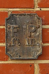
English: Fire point plaque This plaque has been fitted to a newly restored wall at the junction of Norbury Road with West Street (although it has been suggested that the plaque itself dates from World War 2). There is a small stream which disappears into a culvert a few yards away, which was presumably the source of water for it. The suggestion is that under the "ft" would have been written the distance to the point in feet and under "in" the diameter of the pipe or fitting in inches - there is evidence of some figures on the plaque. Thanks to Nigel Cox for identifying it, to John Illingworth for a possible explanation of the "ft" and "in" and to Alan Longbottom for suggesting the dating of the plaque. |
| Date | |
| Source | From geograph.org.uk |
| Author | Ian Capper |
| Attribution (required by the license) | Ian Capper / Fire point plaque / |
| Camera location | | View this and other nearby images on: OpenStreetMap |
|---|
| Object location | | View this and other nearby images on: OpenStreetMap |
|---|
Licensing[edit]

|
This image was taken from the Geograph project collection. See this photograph's page on the Geograph website for the photographer's contact details. The copyright on this image is owned by Ian Capper and is licensed for reuse under the Creative Commons Attribution-ShareAlike 2.0 license.
|
This file is licensed under the Creative Commons Attribution-Share Alike 2.0 Generic license.
Attribution: Ian Capper
- You are free:
- to share – to copy, distribute and transmit the work
- to remix – to adapt the work
- Under the following conditions:
- attribution – You must give appropriate credit, provide a link to the license, and indicate if changes were made. You may do so in any reasonable manner, but not in any way that suggests the licensor endorses you or your use.
- share alike – If you remix, transform, or build upon the material, you must distribute your contributions under the same or compatible license as the original.

_heading:0.00&language=en)
_heading:0.00&language=en)
File history
Click on a date/time to view the file as it appeared at that time.
| Date/Time | Thumbnail | Dimensions | User | Comment | |
|---|---|---|---|---|---|
| current | 08:18, 20 February 2011 | | 426 × 640 (110 KB) | GeographBot (talk | contribs) | == {{int:filedesc}} == {{Information |description={{en|1=Fire point plaque This plaque has been fitted to a newly restored wall at the junction of Norbury Road with West Street (although it has been suggested that the plaque itself dates from World War 2) |
You cannot overwrite this file.
File usage on Commons
There are no pages that use this file.