File:Felstead Road - geograph.org.uk - 805828.jpg
Jump to navigation
Jump to search
No higher resolution available.
Felstead_Road_-_geograph.org.uk_-_805828.jpg (640 × 480 pixels, file size: 60 KB, MIME type: image/jpeg)
Captions
Captions
Add a one-line explanation of what this file represents
Summary[edit]
| Description |
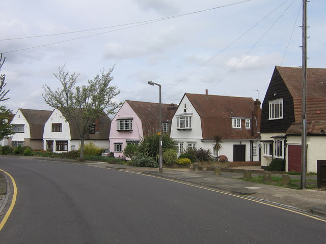
English: Felstead Road One of a number of roads in this part of Orpington named after public schools. Felstead Road was started to be developed between the wars, partly along the route of what a 1920s map shows as the footpath leading from All Saints Church to Goddington. A group of houses in the road are of an unusual "dutch barn" design, as shown here. |
| Date | |
| Source | From geograph.org.uk |
| Author | Ian Capper |
| Attribution (required by the license) | Ian Capper / Felstead Road / |
| Camera location | | View this and other nearby images on: OpenStreetMap |
|---|
_heading:0.00&language=en)
| Object location | | View this and other nearby images on: OpenStreetMap |
|---|
_heading:0.00&language=en)
Licensing[edit]

|
This image was taken from the Geograph project collection. See this photograph's page on the Geograph website for the photographer's contact details. The copyright on this image is owned by Ian Capper and is licensed for reuse under the Creative Commons Attribution-ShareAlike 2.0 license.
|
This file is licensed under the Creative Commons Attribution-Share Alike 2.0 Generic license.
Attribution: Ian Capper
- You are free:
- to share – to copy, distribute and transmit the work
- to remix – to adapt the work
- Under the following conditions:
- attribution – You must give appropriate credit, provide a link to the license, and indicate if changes were made. You may do so in any reasonable manner, but not in any way that suggests the licensor endorses you or your use.
- share alike – If you remix, transform, or build upon the material, you must distribute your contributions under the same or compatible license as the original.
File history
Click on a date/time to view the file as it appeared at that time.
| Date/Time | Thumbnail | Dimensions | User | Comment | |
|---|---|---|---|---|---|
| current | 08:16, 20 February 2011 | | 640 × 480 (60 KB) | GeographBot (talk | contribs) | == {{int:filedesc}} == {{Information |description={{en|1=Felstead Road One of a number of roads in this part of Orpington named after public schools. Felstead Road was started to be developed between the wars, partly along the route of what a 1920s map s |
You cannot overwrite this file.
File usage on Commons
There are no pages that use this file.