File:Federal Capital Territory Nigeria.png
Jump to navigation
Jump to search
No higher resolution available.
Federal_Capital_Territory_Nigeria.png (270 × 221 pixels, file size: 19 KB, MIME type: image/png)
Captions
Captions
Add a one-line explanation of what this file represents
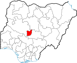
en:Map showing location of Federal Capital Territory in Nigeria
fr:Carte montrant la position du territoire de la capitale fédérale au Nigeria
Drawn by/dessiné par User:Jaimz height-field

|
Permission is granted to copy, distribute and/or modify this document under the terms of the GNU Free Documentation License, Version 1.2 or any later version published by the Free Software Foundation; with no Invariant Sections, no Front-Cover Texts, and no Back-Cover Texts. A copy of the license is included in the section entitled GNU Free Documentation License. |
| This file is licensed under the Creative Commons Attribution-Share Alike 3.0 Unported license. | ||
| ||
| This licensing tag was added to this file as part of the GFDL licensing update. |
File history
Click on a date/time to view the file as it appeared at that time.
| Date/Time | Thumbnail | Dimensions | User | Comment | |
|---|---|---|---|---|---|
| current | 12:41, 17 April 2005 | | 270 × 221 (19 KB) | Jaimz height-field (talk | contribs) | en:Map showing location of Abuja state in Nigeria fr:Carte montrant la position de l'état d'Abuja au Nigeria Drawn by/dessiné par Jaimz height-field {{GFDL}} Category:Maps of Nigeria |
| 18:29, 9 April 2005 |  | 236 × 196 (28 KB) | Jaimz height-field (talk | contribs) | en:Map showing location of Federal Capital Territory in Nigeria fr:Carte montrant la position du territoire de la capitale fédérale au Nigeria Drawn by/dessiné par User:Jaimz height-field {{GFDL}} |
You cannot overwrite this file.
File usage on Commons
The following 5 pages use this file:
File usage on other wikis
The following other wikis use this file:
- Usage on fo.wikipedia.org
- Usage on fy.wikipedia.org
- Usage on ko.wikipedia.org
- Usage on nl.wikipedia.org
- Usage on qu.wikipedia.org
- Usage on zh.wikipedia.org