File:Fastnet-template.jpg
Jump to navigation
Jump to search
No higher resolution available.
Fastnet-template.jpg (150 × 420 pixels, file size: 26 KB, MIME type: image/jpeg)
Captions
Captions
Add a one-line explanation of what this file represents
| Description |
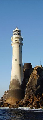
English: Fastnet/Carraig Aonair View from the south west. Surveyors feared that the rock would split, and filled cracks on this side with concrete. |
| Date | |
| Source |
This file was derived from: Fastnet-Carraig Aonair - geograph.org.uk - 257215.jpg |
| Author |
|
| Object location | | View this and other nearby images on: OpenStreetMap |
|---|
_heading:45.00&language=en)
| This is a retouched picture, which means that it has been digitally altered from its original version. Modifications: Made a cropped copy for Irish lighthouses template. The original can be viewed here: Fastnet-Carraig Aonair - geograph.org.uk - 257215.jpg:
|
This file is licensed under the Creative Commons Attribution-Share Alike 2.0 Generic license.
Attribution: Richard Webb
- You are free:
- to share – to copy, distribute and transmit the work
- to remix – to adapt the work
- Under the following conditions:
- attribution – You must give appropriate credit, provide a link to the license, and indicate if changes were made. You may do so in any reasonable manner, but not in any way that suggests the licensor endorses you or your use.
- share alike – If you remix, transform, or build upon the material, you must distribute your contributions under the same or compatible license as the original.
Original upload log[edit]
This image is a derivative work of the following images:
- File:Fastnet-Carraig_Aonair_-_geograph.org.uk_-_257215.jpg licensed with Cc-by-sa-2.0, Geograph
- 2010-08-25T16:57:54Z GeographBot 640x480 (56900 Bytes) == {{int:filedesc}} == {{Information |description={{en|1=Fastnet/Carraig Aonair View from the south west. Surveyors feared that the rock would split, and filled cracks on this side with concrete.}} |date=2006-06-27 |source=F
Uploaded with derivativeFX
File history
Click on a date/time to view the file as it appeared at that time.
| Date/Time | Thumbnail | Dimensions | User | Comment | |
|---|---|---|---|---|---|
| current | 02:15, 23 October 2010 | 150 × 420 (26 KB) | Spideog (talk | contribs) | {{Information |Description={{en|1=Fastnet/Carraig Aonair View from the south west. Surveyors feared that the rock would split, and filled cracks on this side with concrete.}} |date=2006-06-27 |Source=*[[:File:Fastnet-Carraig_Aonair_-_geograph.org.uk_-_25 |
You cannot overwrite this file.
File usage on Commons
There are no pages that use this file.
File usage on other wikis
The following other wikis use this file:
- Usage on en.wikipedia.org
- Lightvessels in Ireland
- List of lighthouses in Ireland
- Inishowen
- Crookhaven
- Ballycotton
- Mizen Head
- Sheep's Head
- Arranmore
- Buncrana
- Old Head of Kinsale
- Fastnet Lighthouse
- Fanad
- Tory Island
- Duncannon
- Slyne Head Lighthouse
- Inisheer
- Rosses Point
- Chaine Memorial
- Inis Cathaigh
- Baily Lighthouse
- Hook Lighthouse
- Wicklow Head
- Dunree
- Kish Bank
- Tuskar Rock, Ireland
- Loop Head
- Donaghadee Lighthouse
- Inishtrahull Lighthouse
- Poolbeg Lighthouse
- Baltimore Beacon
- Rotten Island Lighthouse
- Blacksod Lighthouse
- Template:Irish lighthouses
- User:Spideog/Sandbox/Templates/Irish lighthouses
- Roche's Point Lighthouse
- Eagle Island lighthouses
- Rockabill Lighthouse
- Mine Head Lighthouse
- The Maidens lighthouses
- North Bull Lighthouse
- Haulbowline Lighthouse
- Spit Bank Lighthouse
- Blackhead Lighthouse
- Rathlin O'Birne
- Inisheer Lighthouse
- Eeragh Lighthouse
- Inishmore Lighthouse
- Straw Island Lighthouse
- Metal Man (beacon)
- Howth Harbour Lighthouse
View more global usage of this file.