File:Fashoda Incident map - en.svg
Jump to navigation
Jump to search

Size of this PNG preview of this SVG file: 741 × 600 pixels. Other resolutions: 297 × 240 pixels | 593 × 480 pixels | 949 × 768 pixels | 1,265 × 1,024 pixels | 2,529 × 2,048 pixels | 3,384 × 2,740 pixels.
Original file (SVG file, nominally 3,384 × 2,740 pixels, file size: 272 KB)
Captions
Captions
Fashoda
Summary[edit]
| Title | ||||||||||
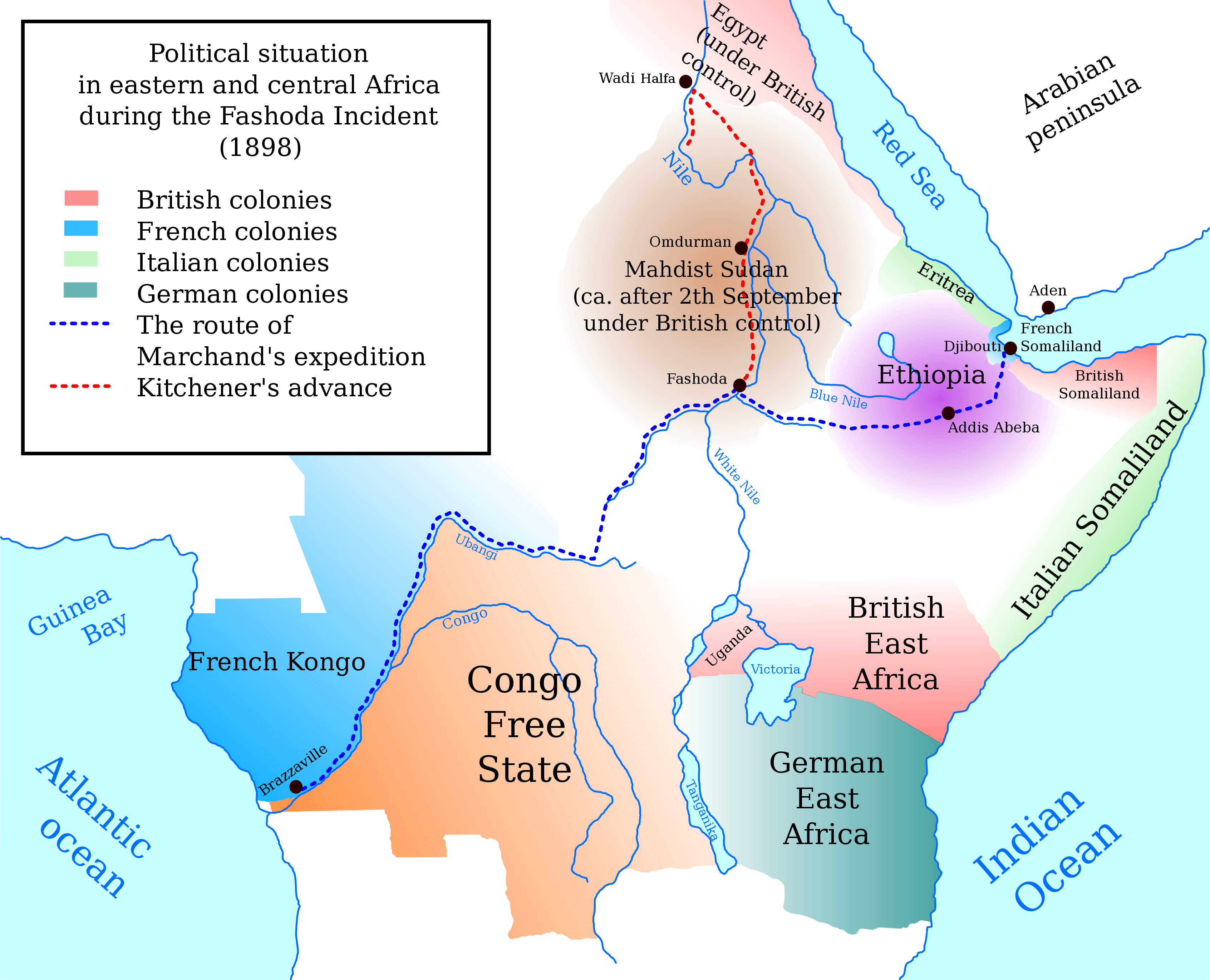
| Map legend |
The route of Marchand's expedition Kitchener's advance |
|||||||||
| Date | ||||||||||
| Source | Own work by Mozzan | |||||||||
| Creator | ||||||||||
| Geotemporal data | ||||||||||
| Date depicted | September 1898 | |||||||||
| Map location | Central Africa and East Africa | |||||||||
| Heading |
 |
|||||||||
| Bounding box |
|
|||||||||
| Georeferencing | If inappropriate please set warp_status = skip to hide. | |||||||||
| Archival data | ||||||||||
| artwork-references |
based on
|
|||||||||
| Other versions | in Czech language: File:Fašoda Incident - cs.svg | |||||||||
.png)
This W3C-unspecified vector image was created with Inkscape .
W3C-validity not checked.

|
This SVG file contains embedded text that can be translated into your language, using any capable SVG editor, text editor or the SVG Translate tool. For more information see: About translating SVG files. |
Licensing[edit]
I, the copyright holder of this work, hereby publish it under the following license:
This file is licensed under the Creative Commons Attribution-Share Alike 3.0 Unported license.
- You are free:
- to share – to copy, distribute and transmit the work
- to remix – to adapt the work
- Under the following conditions:
- attribution – You must give appropriate credit, provide a link to the license, and indicate if changes were made. You may do so in any reasonable manner, but not in any way that suggests the licensor endorses you or your use.
- share alike – If you remix, transform, or build upon the material, you must distribute your contributions under the same or compatible license as the original.
File history
Click on a date/time to view the file as it appeared at that time.
| Date/Time | Thumbnail | Dimensions | User | Comment | |
|---|---|---|---|---|---|
| current | 08:21, 12 June 2012 | | 3,384 × 2,740 (272 KB) | Mozzan (talk | contribs) | Names of rivers corrected |
| 13:28, 15 April 2012 |  | 3,384 × 2,740 (272 KB) | Mozzan (talk | contribs) | another correction | |
| 13:26, 15 April 2012 |  | 3,384 × 2,740 (272 KB) | Mozzan (talk | contribs) | correction of typo | |
| 12:57, 15 April 2012 |  | 3,384 × 2,740 (271 KB) | Mozzan (talk | contribs) |
You cannot overwrite this file.
File usage on Commons
The following page uses this file:
File usage on other wikis
The following other wikis use this file:
- Usage on ar.wikipedia.org
- Usage on ca.wikipedia.org
- Usage on de.wikipedia.org
- Usage on en.wikipedia.org
- Usage on es.wikipedia.org
- Usage on eu.wikipedia.org
- Usage on fr.wikipedia.org
- Usage on gl.wikipedia.org
- Usage on hu.wikipedia.org
- Usage on hy.wikipedia.org
- Usage on ja.wikipedia.org
- Usage on ko.wikipedia.org
- Usage on lv.wikipedia.org
- Usage on nl.wikipedia.org
- Usage on nn.wikipedia.org
- Usage on no.wikipedia.org
- Usage on pl.wikipedia.org
- Usage on pnb.wikipedia.org
- Usage on ro.wikipedia.org
- Usage on ru.wikipedia.org
- Usage on sh.wikipedia.org
- Usage on sr.wikipedia.org
- Usage on sv.wikipedia.org
- Usage on tr.wikipedia.org
- Usage on tum.wikipedia.org
- Usage on ur.wikipedia.org
- Usage on www.wikidata.org