File:Falaise Pocket German Counterattack.png
Jump to navigation
Jump to search
No higher resolution available.
Falaise_Pocket_German_Counterattack.png (800 × 577 pixels, file size: 222 KB, MIME type: image/png)
Captions
Captions
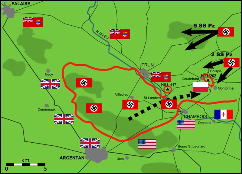
The Falaise Encirclement and Hill 262 - 20 Aug. 1944

|
This battle map image could be re-created using vector graphics as an SVG file. This has several advantages; see Commons:Media for cleanup for more information. If an SVG form of this image is available, please upload it and afterwards replace this template with
{{vector version available|new image name}}.
It is recommended to name the SVG file “Falaise Pocket German Counterattack.svg”—then the template Vector version available (or Vva) does not need the new image name parameter. |
Summary[edit]
| Description |
English: Map of German counterattacks, 20 August 1944, on Polish position on Hill 262, north-east of Chambois, Falaise Pocket, Normandy |
| Date | |
| Source | Own work by uploader from Mémorial de Coudehard - Montormel, the memorial website for the battle. |
| Author | EyeSerene |
Licensing[edit]
| I, the copyright holder of this work, release this work into the public domain. This applies worldwide. In some countries this may not be legally possible; if so: I grant anyone the right to use this work for any purpose, without any conditions, unless such conditions are required by law. |
File history
Click on a date/time to view the file as it appeared at that time.
| Date/Time | Thumbnail | Dimensions | User | Comment | |
|---|---|---|---|---|---|
| current | 00:27, 20 April 2012 | | 800 × 577 (222 KB) | Kbh3rd (talk | contribs) | Added scale bar - snapshot Google maps of same area, overlay in image editor, rotate and scale to match features, and use Google's scale bar as a guide. Approximate but close enough |
| 17:57, 17 January 2010 |  | 800 × 577 (185 KB) | Mahahahaneapneap (talk | contribs) | Compressed | |
| 10:11, 27 April 2009 |  | 800 × 577 (200 KB) | EyeSerene (talk | contribs) | Replace Maple Leaf flag with correct-for-time Red Ensign | |
| 13:05, 30 March 2009 |  | 800 × 577 (216 KB) | Chrzanko (talk | contribs) | corrected the location of Saint Lambert | |
| 17:10, 10 October 2008 |  | 828 × 597 (171 KB) | EyeSerene (talk | contribs) | Replaced Canadian military flags with national flag | |
| 20:11, 4 September 2008 |  | 828 × 597 (174 KB) | EyeSerene (talk | contribs) | {{Information |Description={{en|1=Map of German counterattacks, 20 August 2008, on Polish position on Hill 262, north-east of Chambois, Falaise Pocket, Normandy}} |Source=Own work by uploader |Author=EyeSerene |Date=Sept 2008 |Permissio |
You cannot overwrite this file.
File usage on Commons
There are no pages that use this file.
File usage on other wikis
The following other wikis use this file:
- Usage on da.wikipedia.org
- Usage on de.wikipedia.org
- Usage on en.wikipedia.org
- Usage on ko.wikipedia.org
- Usage on pl.wikipedia.org
- Usage on pt.wikipedia.org
- Usage on ru.wikipedia.org
- Usage on zh.wikipedia.org