File:Faciliteitengemeenten.png
Jump to navigation
Jump to search
No higher resolution available.
Faciliteitengemeenten.png (405 × 333 pixels, file size: 6 KB, MIME type: image/png)
Captions
Captions
Add a one-line explanation of what this file represents

|
This linguistic map image could be re-created using vector graphics as an SVG file. This has several advantages; see Commons:Media for cleanup for more information. If an SVG form of this image is available, please upload it and afterwards replace this template with
{{vector version available|new image name}}.
It is recommended to name the SVG file “Faciliteitengemeenten.svg”—then the template Vector version available (or Vva) does not need the new image name parameter. |
Summary[edit]
| Description |
Brezhoneg: Kartenn Kumunioù Belgia gant aezamantoù yezhel
Deutsch: Karte der Fazilitäten-Gemeinden in Belgien, niederländische Version
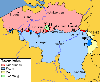
English: Map of Belgian municipalities with language facilities for speakers of the minority language. Version with Dutch-language place names and legend.
Nederlands: Kaart van Belgische gemeenten met taalfaciliteiten voor sprekers van de minderheidstaal. Versie met Nederlandstalige plaatsnamen en legenda. |
| Date | |
| Source | Based on File:Faciliteitengemeenten.png, which is in turn based on http://enciclopedia.us.es/index.php/Archivo:Comunidades_lingüísticas_de_Bélgica.png |
| Author | enciclopedia.us.es:Usuario:Willy, enciclopedia.us.es:Usuario:Pastranec, User:gpvos |
| Other versions |
|


Legenda (officiële namen eerst, namen in minderheidstaal tussen haakjes):
- 1 = Comines-Warneton (Komen-Waasten)
- 2 = Mesen (Messines)
- 3 = Mouscron (Moeskroen)
- 4 = Spiere-Helkijn (Espierres-Helchin)
- 5 = Ronse (Renaix)
- 6 = Flobecq (Vloesberg)
- 7 = Bever (Biévène)
- 8 = Enghien (Edingen)
- 9 = Drogenbos
- 10 = Linkebeek
- 11 = Sint-Genesius-Rode (Rhode-Saint-Genèse)
- 12 = Wemmel
- 13 = Kraainem
- 14 = Wezembeek-Oppem
- 15 = Herstappe
- 16 = Voeren (Fourons)
- 17 = Malmédy (Malmund)
- 18 = Waimes
- 19-22 = Lontzen, Raeren, Eupen, Kelmis (La Calamine)
- 23-27 = Burg-Reuland, Sankt Vith (Saint-Vith), Amel (Amblève), Bütgenbach, Büllingen (Bullange)
Licensing[edit]

|
Permission is granted to copy, distribute and/or modify this document under the terms of the GNU Free Documentation License, Version 1.2 or any later version published by the Free Software Foundation; with no Invariant Sections, no Front-Cover Texts, and no Back-Cover Texts. A copy of the license is included in the section entitled GNU Free Documentation License. |
| This file is licensed under the Creative Commons Attribution-Share Alike 3.0 Unported license. | ||
| ||
| This licensing tag was added to this file as part of the GFDL licensing update. |
File history
Click on a date/time to view the file as it appeared at that time.
| Date/Time | Thumbnail | Dimensions | User | Comment | |
|---|---|---|---|---|---|
| current | 17:22, 27 August 2006 | | 405 × 333 (6 KB) | Gpvos (talk | contribs) | Map of Belgian municipalities with language facilities, with Dutch labels; based on Image:Comunidades lingüísticas de Bélgica.png |
You cannot overwrite this file.
File usage on Commons
The following 5 pages use this file:
File usage on other wikis
The following other wikis use this file:
- Usage on ast.wikipedia.org
- Usage on br.wikipedia.org
- Usage on eo.wikipedia.org
- Usage on es.wikipedia.org
- Usage on eu.wikipedia.org
- Usage on id.wikipedia.org
- Usage on nl.wikipedia.org
- Usage on ro.wikipedia.org
- Usage on zh.wikipedia.org