File:FMIB 33631 Map Showing Geographical Distribution of the North American Menhaden.jpeg
Jump to navigation
Jump to search

Size of this preview: 632 × 599 pixels. Other resolutions: 253 × 240 pixels | 506 × 480 pixels | 810 × 768 pixels | 1,273 × 1,207 pixels.
Original file (1,273 × 1,207 pixels, file size: 386 KB, MIME type: image/jpeg)
Captions
Captions
Add a one-line explanation of what this file represents
Summary
[edit]| Author |
|
|||||||||||||||||||||||
| Description |
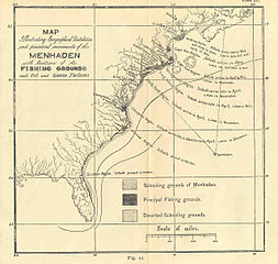
English: Map Showing Geographical Distribution of the North American Menhaden
Annual Movements of the Schools and the Locations of the Fishing-Grounds and the Oil-Factories
|
|||||||||||||||||||||||
| Date | 1877 | |||||||||||||||||||||||
| Collection |
|
|||||||||||||||||||||||
| Current location |
English: Freshwater and Marine Image Bank |
|||||||||||||||||||||||
| Accession number | ||||||||||||||||||||||||
| Source/Photographer |
English: Goode, G. Brown (George Brown) (1879) Natural and Economical History of the American Menhaden, Report of the Commissioner (United States Commission of Fish and Fisheries), 1877, Washington, DC: Government Printing Office |
|||||||||||||||||||||||
| Permission (Reusing this file) |
|
|||||||||||||||||||||||

File history
Click on a date/time to view the file as it appeared at that time.
| Date/Time | Thumbnail | Dimensions | User | Comment | |
|---|---|---|---|---|---|
| current | 06:51, 17 August 2015 | | 1,273 × 1,207 (386 KB) | BMacZeroBot (talk | contribs) |
You cannot overwrite this file.
File usage on Commons
The following page uses this file: