File:FATAmapPakistan.PNG
Jump to navigation
Jump to search

Size of this preview: 643 × 600 pixels. Other resolutions: 257 × 240 pixels | 515 × 480 pixels | 806 × 752 pixels.
Original file (806 × 752 pixels, file size: 189 KB, MIME type: image/png)
Captions
Captions
Add a one-line explanation of what this file represents
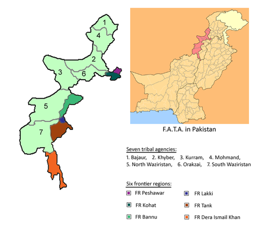
| Description | Seven agencies of Federally Administered Tribal Areas along with Six frontier regions of F.A.T.A. in Pakistan. 1. Bajaur, 2. Khyber, 3. Kurram, 4. Mohmand, 5. North Waziristan, 6. Orakzai, 7. South Waziristan. | ||||||||
| Source | http://en.wikipedia.org/wiki/File:FATA_Pakistan.PNG | ||||||||
| Author | User:Nomi887 | ||||||||
| Permission (Reusing this file) |
English Wikipedia user User:Nomi887, the copyright holder of this work, hereby publishes it under the following license:
|

File history
Click on a date/time to view the file as it appeared at that time.
| Date/Time | Thumbnail | Dimensions | User | Comment | |
|---|---|---|---|---|---|
| current | 07:15, 18 April 2010 | | 806 × 752 (189 KB) | Tianyamm2 (talk | contribs) | {{Information |Description=Seven agencies of Federally Administered Tribal Areas along with Six frontier regions of F.A.T.A. in Pakistan. 1. Bajaur, 2. Khyber, 3. Kurram, 4. Mohmand, 5. North Waziristan, 6. Orakzai, 7. South Waziristan. |Source=http://en. |
You cannot overwrite this file.
File usage on Commons
The following 2 pages use this file:
File usage on other wikis
The following other wikis use this file:
- Usage on de.wikipedia.org
- Usage on en.wikipedia.org
- Usage on fr.wikipedia.org
- Usage on nn.wikipedia.org
- Usage on simple.wikipedia.org
- Usage on zh.wikipedia.org