File:Exacta et Accurata Delineatio 1595.jpg

Original file (27,256 × 20,862 pixels, file size: 62.88 MB, MIME type: image/jpeg)
Captions
Captions
Summary[edit]
| Description |
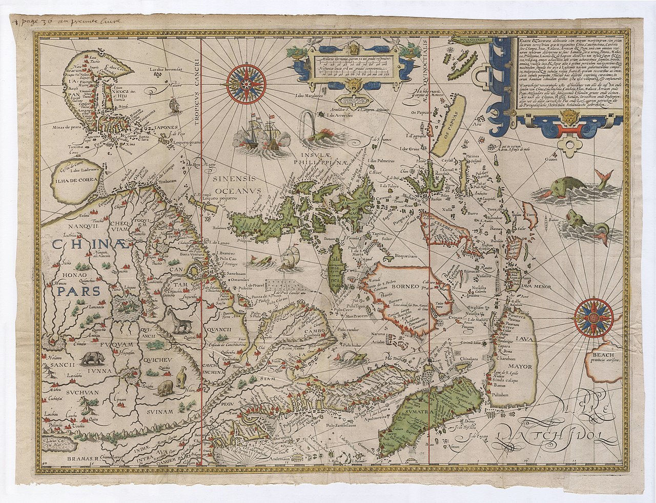
English: An Accurate and Exact Layout of the Bays, Seas, and Lands in the Area of China, Cochinchina, Cambodia or Champa, Siam, Malacca, Arracan, and Pegu along with a Description of All Nearby Islands Including Sumatra, Java, Timor, the Moluccas, the Philippines, Luzon, and the Ryukyus, without Forgetting the Islands of Japan and Korea and Everything Nearby, Taken from the Latest Portuguese Charts.
Latina: Exacta & Accurata Delineatio cum Orarum Maritimarum tum Etiam Locorum Terrestrium quae in Regionibus China, Cauchinchina, Camboja sive Champa, Syao, Malacca, Arracan & Pegu, Una cum Omnium Vicinarum Insularum Descriptione ut Sunt Sumatra, Java, utraque Timora Moluccae, Philippinae, Luconja & Lequeos Dictaenec non Insulae Japan & Corea, Reliquaeque Omnes Adjacentes, ubi Etjam Adnotavimus Scopulos, Brevja, Omniaque Vadosa Loca, & Siquae Alja a quibus Periculum Navigantibus: Quemadmodum Singula Hoc Aevo a Lusitanis Navium Gubernatoribus Comperta Indigetata, & in Tabulas Relata Fuere: E quorum Recentibus ac Emendatis Tabulis perquam Studiose Haec Describi Exprimique Curavimus; in eorum Hominum Commodum quibus Ista Usvi Voluptatique Esse Consueverunt.
Nederlands: Waarachtige Wtworpinghe ofte afbeeldinge van alle dje cullen ende landen van China, Cauchinchina, Camboja, Syao, Malacca, Arracan ende Pegu: Mitsgaders alle dje bijleggende Eyelanden groote ende cleinen. Mit not dje Clippen, Riffen, Sanden, droochten ende Ondjepten: alles wt de alder correckste Pas ende Lees-caarten getrocken dje de Portugaloissche stuyrlvijden huijdendaechs gebruijcken. |
| Date | |
| Source | Leen Helmink Antique Maps, from a 1638 reprint of a 1595 original (Cornelis Claesz., Amsterdam) for the 1596 Itinerario... |
| Author | Drawn by Hendrik Florisz. van Langren (Henricus F[lorentius] ab Langren), engraved by Arnold Florensz. van Langren (Arnoldus F[lorentius] a Langren). Popularly credited to Jan Huygen van Linschoten, who wrote the book. |
Licensing[edit]
|
This work is in the public domain in its country of origin and other countries and areas where the copyright term is the author's life plus 70 years or fewer. This work is in the public domain in the United States because it was published (or registered with the U.S. Copyright Office) before January 1, 1929. | |
| This file has been identified as being free of known restrictions under copyright law, including all related and neighboring rights. | |
File history
Click on a date/time to view the file as it appeared at that time.
| Date/Time | Thumbnail | Dimensions | User | Comment | |
|---|---|---|---|---|---|
| current | 01:33, 16 February 2023 | | 27,256 × 20,862 (62.88 MB) | LlywelynII (talk | contribs) | Uploaded a work by Drawn by Hendrik Florisz. van Langren (Henricus F[lorentius] ab Langren), engraved by Arnold Florensz. van Langren (Arnoldus F[lorentius] a Langren). Popularly credited to Jan Huygen van Linschoten, who wrote the book. from [https://www.helmink.com/antique-map/18959/linschoten-map-of-south-east-asia-1595-exacta-accurata-waarachtige-wtworpinghe Leen Helmink Antique Maps], from a 1638 reprint of a 1595 original for the 1596 ''Itinerario...'' with UploadWizard |
You cannot overwrite this file.
File usage on Commons
The following 3 pages use this file:
.jpg)
File usage on other wikis
The following other wikis use this file:
- Usage on nl.wikipedia.org