File:European regions.svg
From Wikimedia Commons, the free media repository
Jump to navigation
Jump to search

Size of this PNG preview of this SVG file: 560 × 599 pixels. Other resolutions: 224 × 240 pixels | 449 × 480 pixels | 718 × 768 pixels | 957 × 1,024 pixels | 1,914 × 2,048 pixels | 645 × 690 pixels.
Original file (SVG file, nominally 645 × 690 pixels, file size: 437 KB)
File information
Structured data
Captions
Captions
Add a one-line explanation of what this file represents
Summary[edit]
| DescriptionEuropean regions.svg |
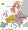
English: European regions and European Core Boundary according to de Blij & Muller (2002). The dotted line marks the boundary of the European core area (the economically and culturally dominating region).
Svenska: Europas regioner enligt de Blij Muller (2002). Den streckade linjen anger gränsen för det europeiska kärnområdet. |
| Date | |
| Source | Own work by uploader. Source: de Blij, Harm J. & Muller, Peter O. (2002). Geography: Realms, Regions and Concepts, Tenth Edition. New York: John Wiley and Sons. |
| Author | Koyos |
Licensing[edit]
| Public domainPublic domainfalsefalse |
| I, the copyright holder of this work, release this work into the public domain. This applies worldwide. In some countries this may not be legally possible; if so: I grant anyone the right to use this work for any purpose, without any conditions, unless such conditions are required by law. |
File history
Click on a date/time to view the file as it appeared at that time.
| Date/Time | Thumbnail | Dimensions | User | Comment | |
|---|---|---|---|---|---|
| current | 21:17, 25 February 2023 |  | 645 × 690 (437 KB) | Iktsokh (talk | contribs) | Final edit |
| 12:47, 8 January 2023 |  | 645 × 690 (507 KB) | Iktsokh (talk | contribs) | White Background Extension | |
| 12:45, 8 January 2023 |  | 645 × 690 (507 KB) | Iktsokh (talk | contribs) | Clearing the map | |
| 12:43, 8 January 2023 |  | 645 × 690 (503 KB) | Iktsokh (talk | contribs) | Countries also referred to Europe (Russia, Turkey, Kazakhstan, Azerbaijan, Armenia, Georgia are highlighted in dark gray). | |
| 21:26, 10 February 2009 |  | 645 × 690 (522 KB) | Koyos (talk | contribs) | White background, optimized SVG. | |
| 21:15, 10 February 2009 |  | 645 × 690 (534 KB) | Koyos (talk | contribs) | {{Information |Description={{en|1=European regions and European Core Boundary according to de Blij, Harm J. & Muller, Peter O. (2002) Geography: Realms, Regions and Concepts, Tenth Edition. New York: John Wiley and Sons. }} {{sv|1=Europeiska regioner and |
You cannot overwrite this file.
File usage on Commons
The following 2 pages use this file:
Metadata
This file contains additional information such as Exif metadata which may have been added by the digital camera, scanner, or software program used to create or digitize it. If the file has been modified from its original state, some details such as the timestamp may not fully reflect those of the original file. The timestamp is only as accurate as the clock in the camera, and it may be completely wrong.
| Short title | Countries of Europe |
|---|---|
| Image title | A blank Map of Europe. Every country has an id which is its ISO-3116-1-ALPHA2 code in lower case.
Members of the EU have a class="eu", countries in europe (which I found turkey to be but russia not) have a class="europe".
Image based on a map (http://commons.wikimedia.org/wiki/Image:Europe_countries.svg) by Júlio "Tintazul" Reis.
made by Marian "maix" Sigler. Released under CreativeCommons Attribution ShareAlike (http://creativecommons.org/licenses/by-sa/2.5/). |
| Width | 645 |
| Height | 690 |
Hidden categories: