File:European countries in which ryainar operates2.svg
Jump to navigation
Jump to search

Size of this PNG preview of this SVG file: 702 × 599 pixels. Other resolutions: 281 × 240 pixels | 562 × 480 pixels | 900 × 768 pixels | 1,199 × 1,024 pixels | 2,399 × 2,048 pixels.
Original file (SVG file, nominally 800 × 683 pixels, file size: 1.3 MB)
Captions
Captions
Add a one-line explanation of what this file represents

|
This file may be updated to reflect new information. If you wish to use a specific version of the file without new updates being mirrored, please upload the required version as a separate file. |
Summary[edit]
| Description |
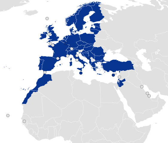
English: Countries with destinations of Ryanair |
| Date | |
| Source | Own work |
| Author | Robert7211 |
Licensing[edit]
I, the copyright holder of this work, hereby publish it under the following license:
This file is licensed under the Creative Commons Attribution-Share Alike 4.0 International license.
- You are free:
- to share – to copy, distribute and transmit the work
- to remix – to adapt the work
- Under the following conditions:
- attribution – You must give appropriate credit, provide a link to the license, and indicate if changes were made. You may do so in any reasonable manner, but not in any way that suggests the licensor endorses you or your use.
- share alike – If you remix, transform, or build upon the material, you must distribute your contributions under the same or compatible license as the original.
File history
Click on a date/time to view the file as it appeared at that time.
| Date/Time | Thumbnail | Dimensions | User | Comment | |
|---|---|---|---|---|---|
| current | 23:55, 11 February 2024 | | 800 × 683 (1.3 MB) | WikiPate (talk | contribs) | revert |
| 19:07, 5 February 2024 |  | 800 × 683 (1.3 MB) | Iktsokh (talk | contribs) | Added countries | |
| 18:16, 12 November 2023 |  | 800 × 683 (1.3 MB) | WikiPate (talk | contribs) | . | |
| 18:05, 12 November 2023 |  | 800 × 683 (1.3 MB) | WikiPate (talk | contribs) | Circles for Gibraltar, Jersey, Guernsey, Faroe Islands and so on. | |
| 17:49, 13 June 2023 |  | 731 × 633 (1.45 MB) | WikiPate (talk | contribs) | added Albania | |
| 19:50, 22 November 2022 |  | 731 × 633 (1.45 MB) | WikiPate (talk | contribs) | The aircraft of the Ryanair group have the range to reach e.g. Cape Verde, Senegal, Gambia and Dubai from a European base. | |
| 08:06, 26 June 2022 |  | 680 × 540 (289 KB) | WikiPate (talk | contribs) | Israel and Jordan can now be seen | |
| 20:04, 19 February 2022 |  | 544 × 559 (1.2 MB) | Robert7211 (talk | contribs) | Cross-wiki upload from en.wikipedia.org |
You cannot overwrite this file.
File usage on Commons
The following 8 pages use this file:
- User:Chumwa/OgreBot/Transport Maps/2023 June 11-20
- User:Chumwa/OgreBot/Transport Maps/2023 November 11-20
- User:Chumwa/OgreBot/Transport Maps/2024 February 1-9
- User:Chumwa/OgreBot/Transport Maps/2024 February 10-19
- User:Chumwa/OgreBot/Travel and communication maps/2023 June 11-20
- User:Chumwa/OgreBot/Travel and communication maps/2023 November 11-20
- User:Chumwa/OgreBot/Travel and communication maps/2024 February 1-9
- User:Chumwa/OgreBot/Travel and communication maps/2024 February 10-19
File usage on other wikis
The following other wikis use this file:
- Usage on ar.wikipedia.org
- Usage on bg.wikipedia.org
- Usage on bs.wikipedia.org
- Usage on ca.wikipedia.org
- Usage on cs.wikipedia.org
- Usage on cy.wikipedia.org
- Usage on da.wikipedia.org
- Usage on de.wikipedia.org
- Usage on el.wikipedia.org
- Usage on en.wikipedia.org
- Usage on eo.wikipedia.org
- Usage on es.wikipedia.org
- Usage on et.wikipedia.org
- Usage on fi.wikipedia.org
- Usage on fr.wikipedia.org
- Usage on ga.wikipedia.org
- Usage on hr.wikipedia.org
- Usage on hu.wikipedia.org
- Usage on hy.wikipedia.org
- Usage on is.wikipedia.org
- Usage on it.wikipedia.org
- Usage on ja.wikipedia.org
- Usage on ko.wikipedia.org
- Usage on lt.wikipedia.org
- Usage on lv.wikipedia.org
- Usage on nl.wikipedia.org
- Usage on no.wikipedia.org
- Usage on pl.wikipedia.org
- Usage on pt.wikipedia.org
- Usage on ro.wikipedia.org
- Usage on sk.wikipedia.org
- Usage on sl.wikipedia.org
- Usage on sr.wikipedia.org
- Usage on sv.wikipedia.org
- Usage on tr.wikipedia.org
- Usage on uk.wikipedia.org
- Usage on zh.wikipedia.org