File:European Spaces.png
Jump to navigation
Jump to search

Size of this preview: 800 × 566 pixels. Other resolutions: 320 × 226 pixels | 640 × 453 pixels | 1,024 × 724 pixels | 1,280 × 906 pixels | 2,560 × 1,811 pixels | 3,507 × 2,481 pixels.
Original file (3,507 × 2,481 pixels, file size: 4.4 MB, MIME type: image/png)
Captions
Captions
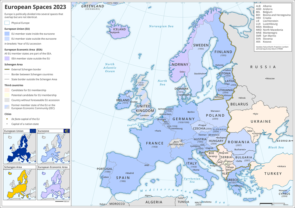
Map of (political) European spaces

|
File:European Spaces Map.svg is a vector version of this file. It should be used in place of this PNG file when not inferior.
File:European Spaces.png → File:European Spaces Map.svg
For more information, see Help:SVG. |
 |
Summary[edit]
| Description |
English: The map shows different (political as well as economic) spaces in Europe, such as the European Union (EU), the Eurozone, the European Economic Area (EEA), the Schengen Area, but also (potential) EU accession candidates and former EU member states.
Deutsch: Die Karte zeigt verschiedene (politische und ökonomische) Räume in Europa, so die Europäische Union (EU), die Eurozone, den Europäischen Wirtschaftsraum (EWR), den Schengen-Raum, aber auch (potentielle) EU-Beitrittskandidaten und frühere EU-Mitglieder. |
| Date | |
| Source | Own work |
| Author | Domser |
Licensing[edit]
I, the copyright holder of this work, hereby publish it under the following license:
This file is licensed under the Creative Commons Attribution-Share Alike 4.0 International license.
- You are free:
- to share – to copy, distribute and transmit the work
- to remix – to adapt the work
- Under the following conditions:
- attribution – You must give appropriate credit, provide a link to the license, and indicate if changes were made. You may do so in any reasonable manner, but not in any way that suggests the licensor endorses you or your use.
- share alike – If you remix, transform, or build upon the material, you must distribute your contributions under the same or compatible license as the original.
File history
Click on a date/time to view the file as it appeared at that time.
| Date/Time | Thumbnail | Dimensions | User | Comment | |
|---|---|---|---|---|---|
| current | 11:45, 9 January 2023 | | 3,507 × 2,481 (4.4 MB) | Iktsokh (talk | contribs) | Final edit |
| 16:44, 8 January 2023 |  | 3,507 × 2,481 (4.35 MB) | Iktsokh (talk | contribs) | Correction of borders | |
| 16:40, 8 January 2023 |  | 3,507 × 2,481 (4.35 MB) | Iktsokh (talk | contribs) | De jure indication of the borders of states (including Ukraine) without taking into account the annexed ones (as with Moldovan Transnistria). The applicant country has been added, which does not fit due to the truncated map format (Georgia). | |
| 13:36, 31 December 2022 |  | 3,508 × 2,480 (2.44 MB) | Domser (talk | contribs) | Visual improvements | |
| 13:26, 31 December 2022 |  | 3,508 × 2,480 (2.44 MB) | Domser (talk | contribs) | BIH as candidate for EU membership | |
| 13:19, 31 December 2022 |  | 3,508 × 2,480 (2.44 MB) | Domser (talk | contribs) | Update for 2023: Croatia as a member of the eurozone and Schengen area | |
| 08:41, 13 September 2022 |  | 3,507 × 2,481 (4.39 MB) | Рагин1987 (talk | contribs) | Correction | |
| 08:10, 13 September 2022 |  | 3,508 × 2,480 (2.31 MB) | Рагин1987 (talk | contribs) | Small correction | |
| 19:12, 27 August 2022 |  | 3,508 × 2,480 (2.66 MB) | Nameless23 (talk | contribs) | Ukraine and Moldova are now EU accession candidates, see https://ec.europa.eu/environment/enlarg/candidates.htm | |
| 15:28, 5 June 2022 |  | 3,508 × 2,480 (2.43 MB) | Domser (talk | contribs) | Ukraine and Moldova currently do not have the official status of potential candidate for EU membership (see EU Commission website: https://ec.europa.eu/neighbourhood-enlargement/enlargement-policy/negotiations-status_en) |
You cannot overwrite this file.
File usage on Commons
The following 6 pages use this file:
File usage on other wikis
The following other wikis use this file:
- Usage on ar.wikipedia.org
- Usage on en.wikipedia.org
- Usage on eo.wikipedia.org
- Usage on es.wikipedia.org
- Usage on fa.wikipedia.org
- Usage on ko.wikipedia.org
- Usage on zh.wikipedia.org