File:Europe map 1648-es.png
Jump to navigation
Jump to search

Size of this preview: 800 × 577 pixels. Other resolutions: 320 × 231 pixels | 640 × 462 pixels | 1,024 × 739 pixels | 1,280 × 924 pixels | 1,894 × 1,367 pixels.
Original file (1,894 × 1,367 pixels, file size: 141 KB, MIME type: image/png)
Captions
Captions
Add a one-line explanation of what this file represents
| Description |
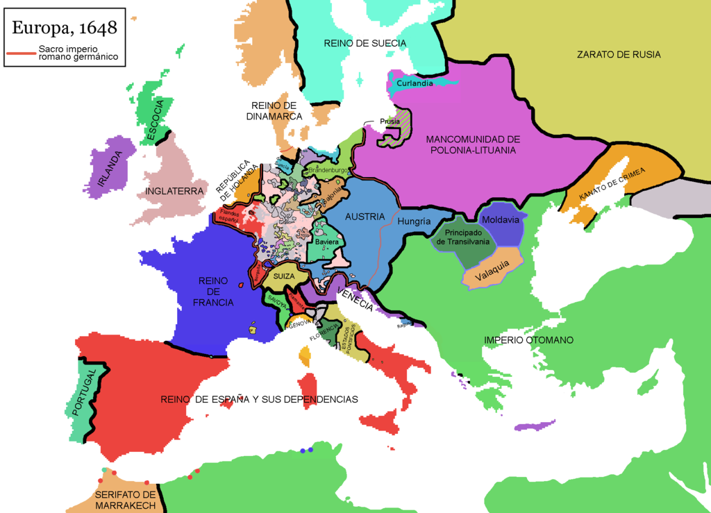
English: Map of Europe in 1648, at the end of the Thirty Years War. Red line marks the border of the Holy Roman Empire. (Labels in Spanish).
Español: Mapa de Europa en 1648, al final de la guerra de los treinta años. La línea roja marca las fronteras del Sacro imperio romano germánico.
Falta por cambiar el nombre de Piamonte, que es erroneo, la zona es el Milanesado o Ducado de Milan |
| Date | (UTC) |
| Source | |
| Author |
|
| This is a retouched picture, which means that it has been digitally altered from its original version. Modifications: Rótulos en español (labels in Spanis) + Hungría. The original can be viewed here: Europe map 1648.PNG:
|
I, the copyright holder of this work, hereby publish it under the following licenses:
| This file is licensed under the Creative Commons Attribution-Share Alike 3.0 Unported license. | ||
| ||
| This licensing tag was added to this file as part of the GFDL licensing update. |

|
Permission is granted to copy, distribute and/or modify this document under the terms of the GNU Free Documentation License, Version 1.2 or any later version published by the Free Software Foundation; with no Invariant Sections, no Front-Cover Texts, and no Back-Cover Texts. A copy of the license is included in the section entitled GNU Free Documentation License. |
You may select the license of your choice.
Original upload log[edit]
This image is a derivative work of the following images:
- File:Europe_map_1648.PNG licensed with Cc-by-sa-3.0-migrated, GFDL
- 2010-09-25T11:40:35Z Fakirbakir 1894x1367 (197540 Bytes) Minor
- 2010-09-25T10:45:19Z Fakirbakir 1894x1367 (197532 Bytes) Transylvania Moldavia and Wallachia were a 'semi-independent' state under the suzerainty of the Ottoman Empire.
- 2008-12-12T02:13:45Z Mathiasrex 1894x1367 (197990 Bytes) In 1648 Duchy of Prussia was yet a fief of the Polish Crown
- 2008-11-04T22:12:11Z Beliar 1894x1367 (197454 Bytes) Holstein was part of the HRE but was ruled by the danish king in personal union as the duce of H.
- 2007-10-24T07:09:47Z Conscious 1894x1367 (186157 Bytes) "Tsardom of Russia" instead of "Russian Empire" (this is a pre-1721 map)
- 2007-01-10T05:47:14Z Roke 1894x1367 (186110 Bytes) more detail HRE, fixes
- 2006-06-08T00:10:58Z Roke 1894x1367 (186146 Bytes) change to polish-lithuanian commonwealth after comment on en
- 2006-05-09T09:08:45Z Roke 1894x1367 (184339 Bytes) cropped right version
- 2006-05-08T13:12:58Z Roke 1894x1374 (111881 Bytes) minor crop
- 2006-05-05T05:12:47Z Roke 1900x1378 (185935 Bytes) Map of Europe in 1648 (at the end of the [[w:Thirty Years War|Thirty Years War]], based on free map of europe [[:Image:BlankMap-Europe.png]] {{Europe}} [[Category:Historical maps of Europe]]
Uploaded with derivativeFX
File history
Click on a date/time to view the file as it appeared at that time.
| Date/Time | Thumbnail | Dimensions | User | Comment | |
|---|---|---|---|---|---|
| current | 11:48, 10 November 2017 | | 1,894 × 1,367 (141 KB) | Raderich (talk | contribs) | Corregidos algunos errores en el mapa. |
| 15:52, 9 September 2017 |  | 1,894 × 1,367 (134 KB) | Daniel Medina (talk | contribs) | Corregidas algunas erratas heredadas de la imagen original en inglés de 2010 en base a la versión de 2017 de la misma imagen (Media:Europe_map_1648.PNG. Concretamente se añaden: • la anexión de Cataluña por parte de Francia • enclaves f... | |
| 14:23, 3 May 2013 |  | 1,894 × 1,367 (121 KB) | Osado (talk | contribs) | Label improvement; Burgundia → Borgoña | |
| 14:15, 3 May 2013 |  | 1,894 × 1,367 (150 KB) | Osado (talk | contribs) | Reverted to version as of 11:31, 4 August 2011 | |
| 09:57, 2 May 2013 |  | 1,894 × 1,367 (121 KB) | Osado (talk | contribs) | Label improvement; Burgundia → Borgoña | |
| 11:31, 4 August 2011 |  | 1,894 × 1,367 (150 KB) | Osado (talk | contribs) | {{Information |Description={{en|Map of Europe in 1648, at the end of the Thirty Years War. Red line marks the border of the Holy Roman Empire. (Labels in Spanish).}} {{es|Mapa de Europa en 1648, al final de la guerra de los treinta años. La línea roja m |
You cannot overwrite this file.
File usage on Commons
The following page uses this file:
File usage on other wikis
The following other wikis use this file:
- Usage on ast.wikipedia.org
- Usage on es.wikipedia.org
- Usage on es.wikibooks.org
- Usage on eu.wikipedia.org
- Usage on pt.wikipedia.org
- Usage on www.wikidata.org
- Usage on wuu.wikipedia.org