File:Europe 1848 map ru.png
Jump to navigation
Jump to search
Size of this preview: 800 × 526 pixels. Other resolutions: 320 × 211 pixels | 640 × 421 pixels | 1,024 × 674 pixels | 1,280 × 842 pixels | 2,284 × 1,503 pixels.
Original file (2,284 × 1,503 pixels, file size: 1.23 MB, MIME type: image/png)
Captions
Captions
Add a one-line explanation of what this file represents
Summary[edit]
| Description |
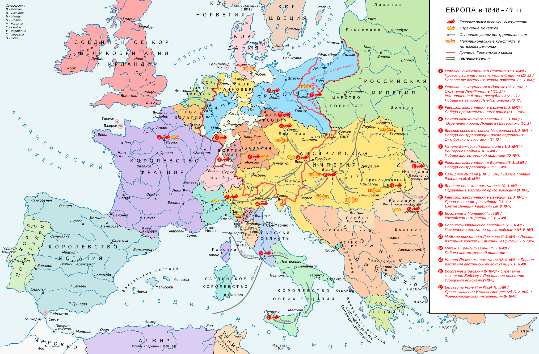
English: Europe 1848-49. Historical map with main revolutionary centres, important reactionary troop movements, states with abdications and national conflicts. Please don't alter the map, when you think there something not written or depicted correctly. Leave a message at the talk page of the file. After a verificiation and a possible discussion, i will upload a new map version with all new changes. This prevents an unnecessary waste of disc space and ensures a good result, aesthetically and contentwise. - The author. Русский: Европа в 1848-49 годах. Историческая карта, обозначающая основные революционные центры, важнейшие передвижения реакционных войск, отречения от трона и национальные конфликты.
Пожалуйста, не вносите изменений в эту карту, если считаете, что здесь есть ошибки или отсутствует что-то важное. Оставьте сообщение на странице обсуждения файла. После проверки и, возможно, общения с вами я загружу новую версию карты со всеми изменениями. Это экономит место на сервере и гарантирует хороший результат и с точки зрения эстетики, и с точки зрения содержания. - Автор. Deutsch: Europa 1848/49. Historische Karte mit wichtigen revolutionären Orten, Hauptschlagrichtungen konterrevolutionärer Truppen, Staaten mit Abdankungen von Monarchen und Nationalitätenkonflikten. Bitte die Karte bei Änderungs- und Korrekturwünschen nicht selbst verändern, sondern eine Anmerkung im Diskussionsbereich der Bilddatei hinterlassen. Nach einer Prüfung und ggfs. Diskussion werden evtl. Änderungen von mir zusammengefasst eingearbeitet. Das vermeidet unnötige Speicherplatz-Verschwendung und gewährleistet ein ästhetisch ansprechendes und inhaltlich korrektes Ergebnis. - Der Urheber. |
| Date | |
| Source |
Own work. Source of Information: Historical atlases – Ramsay Muir, George Philip (ed.): Philip's New School Atlas of Universal History, George Philip & Son, Ltd., London 1928 – Dr. Walter Leisering (ed.): Putzger Historischer Weltatlas, Cornelsen Verlag, Berlin 1992, ISBN 3-464-00176-8 – Bayerischer Schulbuch-Verlag (ed.): Großer Historischer Weltatlas, Dritter Teil, Neuzeit, Bayerischer Schulbuch-Verlag, München 1981, ISBN 3-7627-6021-7 – Prof. Dr. Vadim Oswalt u. Prof. Dr. Hans Ulrich Rudolf (ed.): Klett-Perthes Atlas zur Weltgeschichte, Ernst Klett Verlag, Stuttgart 2011, ISBN 978-3-12-828194-0 – Zentralinstitut für Geschichte der Akademie der Wissenschaften der DDR (ed.): Atlas zur Geschichte, Band 1, VEB Hermann Haack, Gotha 1989, ISBN 3-7301-0040-8 – Domokos György (ed.): Történelmi atlasz a középiskolák számára, Kartográfiai Vállalat. Budapest, Budapest 1989, ISBN 963-351-422-3 Other publications – Mike Rapport: 1848. Revolution in Europa, Wissenschaftliche Buchgesellschaft, Lizenzausgabe des Konrad Theiss Verlags, 2011, ISBN 978-3-534-23963-4 |
| Author | Russian translation: Kaidor, Messir |
| Other versions |
|


Recompressed without quality loss with OptiPNG (1.55 MB > 1.23 MB)
Licensing[edit]
I, the copyright holder of this work, hereby publish it under the following license:
This file is licensed under the Creative Commons Attribution-Share Alike 4.0 International license.
- You are free:
- to share – to copy, distribute and transmit the work
- to remix – to adapt the work
- Under the following conditions:
- attribution – You must give appropriate credit, provide a link to the license, and indicate if changes were made. You may do so in any reasonable manner, but not in any way that suggests the licensor endorses you or your use.
- share alike – If you remix, transform, or build upon the material, you must distribute your contributions under the same or compatible license as the original.
Licensing[edit]
This file is licensed under the Creative Commons Attribution-Share Alike 4.0 International license.
- You are free:
- to share – to copy, distribute and transmit the work
- to remix – to adapt the work
- Under the following conditions:
- attribution – You must give appropriate credit, provide a link to the license, and indicate if changes were made. You may do so in any reasonable manner, but not in any way that suggests the licensor endorses you or your use.
- share alike – If you remix, transform, or build upon the material, you must distribute your contributions under the same or compatible license as the original.
File history
Click on a date/time to view the file as it appeared at that time.
| Date/Time | Thumbnail | Dimensions | User | Comment | |
|---|---|---|---|---|---|
| current | 19:44, 8 June 2017 | | 2,284 × 1,503 (1.23 MB) | KaterBegemot (talk | contribs) | == {{int:filedesc}} == {{Information |Description ={{en|1=Europe 1848-49. Historical map with main revolutionary centres, important reactionary troop movements, states with abdications and national conflicts.<br> ''Please don't alter the map, when y... |
You cannot overwrite this file.
File usage on Commons
The following 2 pages use this file:
File usage on other wikis
The following other wikis use this file:
- Usage on ru.wikipedia.org