File:Europe 1748-1766 blank.png
Jump to navigation
Jump to search
Size of this preview: 800 × 570 pixels. Other resolutions: 320 × 228 pixels | 640 × 456 pixels | 1,024 × 730 pixels | 1,280 × 913 pixels | 2,560 × 1,825 pixels | 3,872 × 2,761 pixels.
Original file (3,872 × 2,761 pixels, file size: 855 KB, MIME type: image/png)
Captions
Captions
Add a one-line explanation of what this file represents
Summary[edit]
| Description |
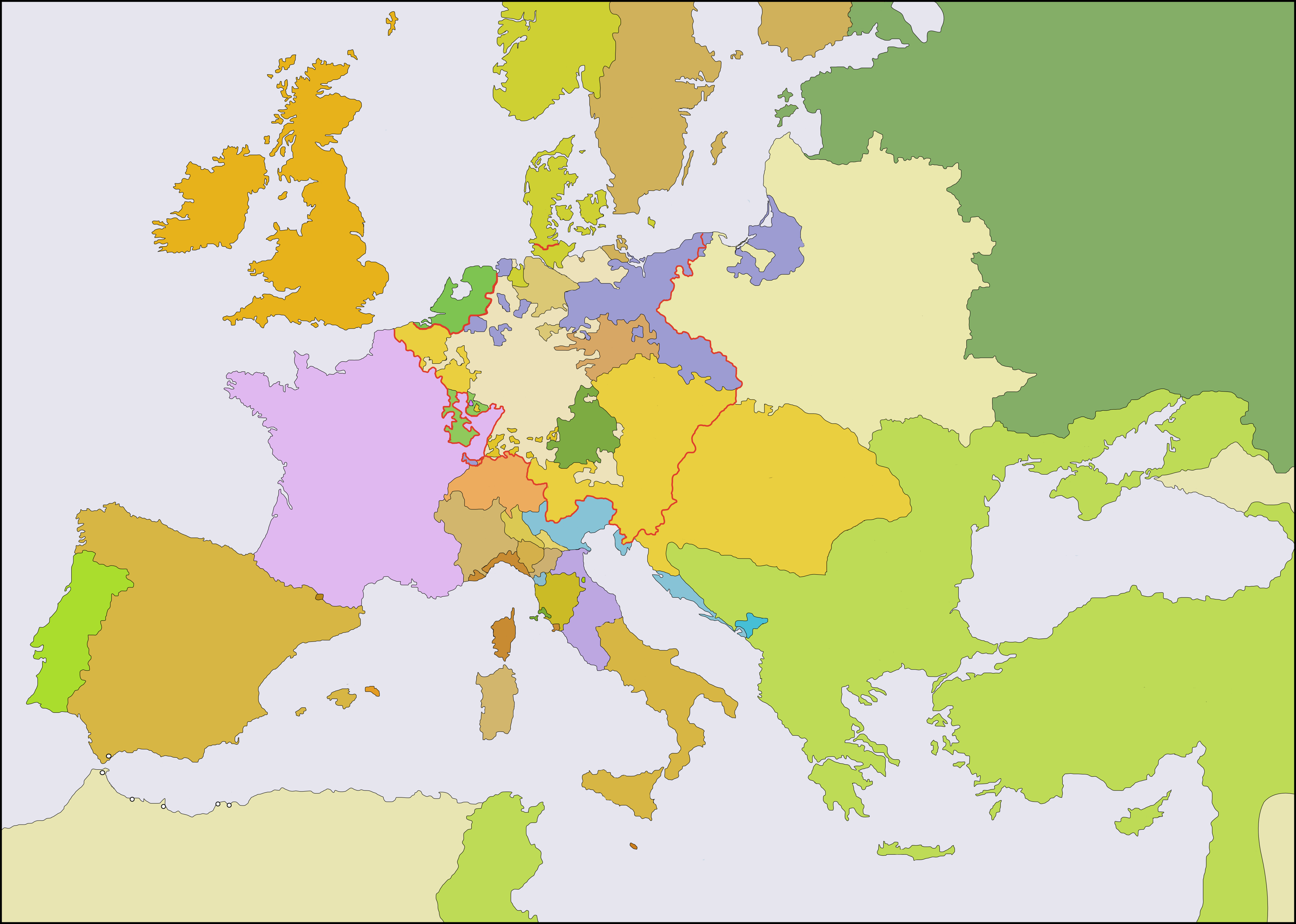
Deutsch: Diese Karte zeigt Europa in den Jahren nach dem Frieden von Aachen 1748 und in der Zeit des Siebenjährigen Krieges (1756-1763). Bis 1766 kam es zu keinen größeren geographischen Veränderungen in Europa.
Die Arbeit wurde mit Inkscape erstellt und beruht hauptsächlich auf einer Karte in: Putzger - Historischer Weltatlas, Berlin 1990, S.78f.
English: This map shows Europe in the years after the Treaty of Aix-la-Chapelle 1748 and the Seven Years' War (1756-1763). Europe did not see another major geographical change until 1766. The red line marks the borders of the Holy Roman Empire.
The work was created with Inkscape and is mainly based on a map in: Putzger - Historischer Weltatlas, Berlin 1990, 78 pp.
Français : Cette carte montre l'Europe dans les années après le Traité d'Aix-la-Chapelle (1748) et pendant les années de la Guerre des Sept Ans (1756-1763). L'Europe n'a pas vu un autre changement géographique important jusqu'à 1766.
Le travail a été créé avec Inkscape et il est basé principalement sur une carte dans: Putzger - Historischer Weltatlas, Berlin 1990, 78 pp.
Polski: Ta mapa ukazuje Europę w latach po pokoju w Akwizgranie z 1748 i wojnie siedmioletniej (1756-1763). Europa nie uświadczyła żadnych poważniejszych zmian geograficznych aż do 1766. Czerwona linia znaczy granice Świętego Cesarstwa Rzymskiego.
Praca została stworzona z użyciem Inkscape i powstała głównie na bazie mapy w: Putzger - Historischer Weltatlas, Berlin 1990, 78 pp.
Русский: Эта карта представляет Европу после заключения Аахенского мира в 1748 г. и во время Семилетней войны (1756-1763 гг.). До 1766 г. эта картина Европы не исменилась.
Эта работа нарисована с помощью программы Inkscape и основана на карте из книги: Putzger - Historischer Weltatlas, Berlin 1990, 78 cc. |
| Date | |
| Source |
This file was derived from: Europe 1748-1766.png |
| Author | P. S. Burton |
Licensing[edit]
I, the copyright holder of this work, hereby publish it under the following license:
This file is licensed under the Creative Commons Attribution 3.0 Unported license.
- You are free:
- to share – to copy, distribute and transmit the work
- to remix – to adapt the work
- Under the following conditions:
- attribution – You must give appropriate credit, provide a link to the license, and indicate if changes were made. You may do so in any reasonable manner, but not in any way that suggests the licensor endorses you or your use.
File history
Click on a date/time to view the file as it appeared at that time.
| Date/Time | Thumbnail | Dimensions | User | Comment | |
|---|---|---|---|---|---|
| current | 02:52, 21 October 2017 | | 3,872 × 2,761 (855 KB) | Bryanrutherford0 (talk | contribs) | Transferred control of Saaremaa and Hiiumaa to Russia (1721 Treaty of Nystad) and adjusted Russian-Swedish border in Finland to reflect Russian gains in the 1743 Treaty of Åbo after the Russo-Swedish War. |
| 21:21, 3 May 2013 |  | 3,872 × 2,761 (855 KB) | P. S. Burton (talk | contribs) | == {{int:filedesc}} == {{Information |Description={{de|1=Diese Karte zeigt Europa in den Jahren nach dem Frieden von Aachen 1748 und in der Zeit des Siebenjährigen Krieges (1756-1763). Bi... |
You cannot overwrite this file.
File usage on Commons
The following page uses this file:
File usage on other wikis
The following other wikis use this file:
- Usage on ar.wikipedia.org
- ويكيبيديا:صناديق المستخدم/تاريخ
- مستخدم:ELAMEEN7
- مستخدم:Ramses Nagib
- مستخدم:Abdullah.alkhalaf1
- مستخدم:AHMADX6
- مستخدم:محمد ومن
- مستخدم:صندوق مستخدم/مستخدم تاريخ أوروبا
- مستخدم:Mohamadfeda
- ويكيبيديا:صناديق المستخدم/علوم/علوم إجتماعية
- مستخدم:Nmnooh/ملعب
- مستخدم:عمرو حاتم
- مستخدم:Mohamadfeda/صناديقي
- مستخدم:Mohammad Eyad Subeh
- مستخدم:Norval771
- مستخدم:Norval771/المقدمة
- مستخدم:فهد المسلم
- مستخدم:BroXadal/صناديقي
- مستخدم:Kelcoz
- Usage on fr.wikipedia.org
- Usage on ru.wikipedia.org