File:Europa 1815.svg
Jump to navigation
Jump to search

Size of this PNG preview of this SVG file: 589 × 599 pixels. Other resolutions: 236 × 240 pixels | 472 × 480 pixels | 755 × 768 pixels | 1,007 × 1,024 pixels | 2,013 × 2,048 pixels | 1,340 × 1,363 pixels.
Original file (SVG file, nominally 1,340 × 1,363 pixels, file size: 554 KB)
Captions
Captions
Add a one-line explanation of what this file represents
Summary[edit]
| Description |
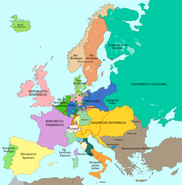
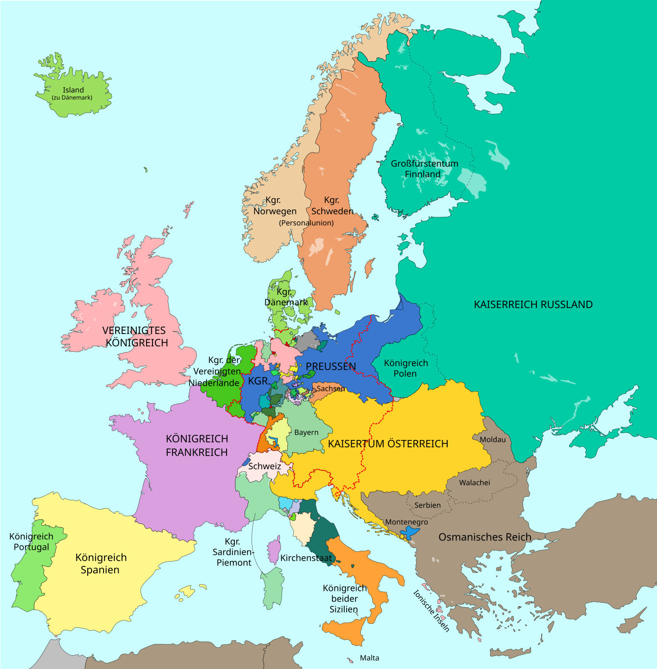
Deutsch: Europa im Jahr 1815 nach dem Wiener Kongress. Großmächte in GROSSBUCHSTABEN.
Russland
Frankreich
Vereinigtes Königreich
Preußen
Österreich und habsburgischer Besitz
Grenze des Deutschen Bundes (1815) English: Map of Europe 1815 after the Congress of Vienna. Great Powers in CAPITAL LETTERS.
Russia
France
United Kingdom
Prussia
Austria and Habsburg possessions
Border of the German Confederation (1815) Català: Mapa d'Europa 1815 després del Congrés de Viena. Grans potències en lletra majúscula.
Rússia
França
Regne Unit
Prússia
Àustria i possessions dels Habsburg
Frontera de la Confederació Alemanya (1815) |
| Date | (UTC), largely revised version: 2016-10-06 |
| Source |
This file was derived from: A blank map of Europe ca. 1815.svg: File:A blank map of Europe ca. 1815.svg |
| Author |
|
| Other versions |
|
| SVG development | This vector image was created with Adobe Illustrator. This file uses embedded text that can be easily translated using a text editor. |


|
This SVG file contains embedded text that can be translated into your language, using any capable SVG editor, text editor or the SVG Translate tool. For more information see: About translating SVG files. |
_en.png)
.png)
.jpg)
Licensing[edit]

|
Permission is granted to copy, distribute and/or modify this document under the terms of the GNU Free Documentation License, Version 1.2 or any later version published by the Free Software Foundation; with no Invariant Sections, no Front-Cover Texts, and no Back-Cover Texts. A copy of the license is included in the section entitled GNU Free Documentation License. |
| This file is licensed under the Creative Commons Attribution-Share Alike 3.0 Unported license. | ||
| ||
| This licensing tag was added to this file as part of the GFDL licensing update. |
This file is licensed under the Creative Commons Attribution-Share Alike 2.5 Generic license.
- You are free:
- to share – to copy, distribute and transmit the work
- to remix – to adapt the work
- Under the following conditions:
- attribution – You must give appropriate credit, provide a link to the license, and indicate if changes were made. You may do so in any reasonable manner, but not in any way that suggests the licensor endorses you or your use.
- share alike – If you remix, transform, or build upon the material, you must distribute your contributions under the same or compatible license as the original.
Original upload log[edit]
This image is a derivative work of the following images:
- File:Map-GermanConfederation.svg licensed with Cc-by-sa-2.5, Cc-by-sa-3.0-migrated, GFDL, GFDL-user-en-note
- 2011-01-18T15:49:48Z Beao 9031x7615 (1364487 Bytes) Removed border
- 2007-04-13T19:20:08Z 52 Pickup 9086x7672 (1815864 Bytes) {{Information| |Description= The [[:en:German Confederation|German Confederation]] ([[:de:Deutscher Bund|Deutscher Bund]]) - map from 1820 |Source= Based on map data of the IEG-Maps project (Andreas Kunz, B. Johnen and Joachi
Uploaded with derivativeFX
File history
Click on a date/time to view the file as it appeared at that time.
| Date/Time | Thumbnail | Dimensions | User | Comment | |
|---|---|---|---|---|---|
| current | 12:46, 15 September 2023 | | 1,340 × 1,363 (554 KB) | Lalpino (talk | contribs) | File uploaded using svgtranslate tool (https://svgtranslate.toolforge.org/). Added translation for ca. |
| 17:30, 30 October 2016 |  | 1,340 × 1,363 (549 KB) | Furfur (talk | contribs) | kleine Korrekturen (Fürstentum Birkenfeld, Wetzlar, Freie Stadt Frankfurt, Hessen-Homburg) | |
| 10:19, 22 October 2016 |  | 1,340 × 1,363 (548 KB) | Furfur (talk | contribs) | Schweden und Norwegen doch verschieden eingefärbt – trotz Personalunion zwei verschiedene Staaten; Algerien und Tunesien in der Farbe des Osmanischen Reichs | |
| 11:07, 20 October 2016 |  | 1,340 × 1,363 (547 KB) | Furfur (talk | contribs) | Details (u. a. Bild vergrößert, Meeresdarbe heller) | |
| 19:33, 6 October 2016 |  | 893 × 907 (521 KB) | Furfur (talk | contribs) | Detailkorrektur | |
| 19:26, 6 October 2016 |  | 893 × 907 (521 KB) | Furfur (talk | contribs) | Details | |
| 19:07, 6 October 2016 |  | 893 × 907 (520 KB) | Furfur (talk | contribs) | Korrekturen | |
| 18:59, 6 October 2016 |  | 893 × 907 (518 KB) | Furfur (talk | contribs) | bessere Karte | |
| 16:54, 29 September 2016 |  | 905 × 762 (2.16 MB) | Furfur (talk | contribs) | Detail (Meer etwas heller) | |
| 16:59, 9 December 2014 |  | 905 × 762 (2.16 MB) | Furfur (talk | contribs) | + blue coast line |
You cannot overwrite this file.
File usage on Commons
The following 17 pages use this file:
- User:J budissin/Uploads/BiH/2016 October 1-10
- User:J budissin/Uploads/BiH/2016 October 11-20
- User:J budissin/Uploads/BiH/2016 October 21-31
- User:J budissin/Uploads/BiH/2016 September 21-30
- User:Magog the Ogre/Multilingual legend/2023 September 11-15
- File:Europa 1701.svg
- File:Europa 1721.svg
- File:Europa 1789.svg
- File:Europa 1812.svg
- File:Europa 1815.svg
- File:Europa 1818.svg (file redirect)
- File:Europa 1861.svg
- File:Europa 1867.svg
- File:Europa 1914.svg
- File:Europa 1929.svg
- File:Map congress of vienna.jpg
- Template:Other versions/Europa 1815
File usage on other wikis
The following other wikis use this file:
- Usage on af.wikipedia.org
- Usage on azb.wikipedia.org
- Usage on ca.wikipedia.org
- Usage on de.wikipedia.org
- Usage on en.wikipedia.org
- Usage on eo.wikipedia.org
- Usage on et.wikipedia.org
- Usage on it.wikipedia.org
- Usage on rm.wikipedia.org
- Usage on stq.wikipedia.org
- Usage on zh.wikipedia.org