File:Europa 1812.svg
Jump to navigation
Jump to search

Size of this PNG preview of this SVG file: 600 × 600 pixels. Other resolutions: 240 × 240 pixels | 480 × 480 pixels | 768 × 768 pixels | 1,024 × 1,024 pixels | 2,048 × 2,048 pixels | 1,357 × 1,357 pixels.
Original file (SVG file, nominally 1,357 × 1,357 pixels, file size: 511 KB)
Captions
Captions
Add a one-line explanation of what this file represents
Summary[edit]
| Description |
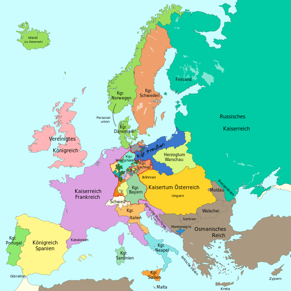
Deutsch: Eine einfache Karte von Europa am Vorabend von Napoleons Russlandfeldzug 1812.
Grenze des Rheinbundes English: A simple map showing Europe at the start of the Napoleons war against Russia.
Border of the Confederation of the Rhine Català: Mapa simplificat d'Europa a la vigília de la campanya russa de Napoleó el 1812.
Frontera de la Confederació del Rin |
||
| Date | |||
| Source |
This file was derived from: Blank map of Europe 1812.svg |
||
| Author |
|
||
| Permission (Reusing this file) |
I, the copyright holder of this work, hereby publish it under the following licenses:
This file is licensed under the Creative Commons Attribution-Share Alike 4.0 International license.
You may select the license of your choice. |
||
| Other versions |
|
||
| SVG development | This vector image was created with Adobe Illustrator. |


File history
Click on a date/time to view the file as it appeared at that time.
| Date/Time | Thumbnail | Dimensions | User | Comment | |
|---|---|---|---|---|---|
| current | 18:13, 16 September 2023 | | 1,357 × 1,357 (511 KB) | Lalpino (talk | contribs) | File uploaded using svgtranslate tool (https://svgtranslate.toolforge.org/). Added translation for ca. |
| 08:25, 22 October 2016 |  | 1,357 × 1,357 (502 KB) | Furfur (talk | contribs) | == {{int:filedesc}} == {{Information |Description={{User:Medium69/Traduction}} {{de|1=Eine einfache Karte von Europa am Vorabend von Napoleons Russlandfeldzug 1812.}} {{en|1=A simple map showing Europe at the start of the Napoleons war against Russia.}... |
You cannot overwrite this file.
File usage on Commons
The following 11 pages use this file:
File usage on other wikis
The following other wikis use this file:
- Usage on ca.wikipedia.org
- Usage on en.wikipedia.org