File:Etruscan civilization map ua.PNG
From Wikimedia Commons, the free media repository
Jump to navigation
Jump to search

Size of this preview: 494 × 600 pixels. Other resolutions: 198 × 240 pixels | 395 × 480 pixels | 633 × 768 pixels | 843 × 1,024 pixels | 1,500 × 1,821 pixels.
Original file (1,500 × 1,821 pixels, file size: 519 KB, MIME type: image/png)
File information
Structured data
Captions
Captions
Add a one-line explanation of what this file represents
Summary[edit]
| DescriptionEtruscan civilization map ua.PNG |
[edit]
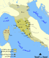
Català: Un mapa que mostra l'extensió d'Etruria i la civilització etrusca. El mapa inclou les 12 ciutats de la Lliga Etrusca i ciutats notables fundades pels etruscs. Les dates del mapa són una aproximació. English: A map showing the extent of Etruria and the Etruscan civilization. The map includes the 12 cities of the Etruscan League and notable cities founded by the Etruscans. The dates on the map are an approximation. Español: Expansión etrusca entre el 750 y el 500 a. de C., las ciudades de la Liga etrusca y otras notables fundadas por los etruscos. Português: Mapa da expansão etrusca entre 750-500 Suomi: Kartta Etruriasta ja etruskien sivilisaatiosta sen ollessa laajimmillaan. Karttaan on merkitty etruskien kaupunkiliiton 12 kaupunkia sekä muita etruskien perustamia merkittäviä kaupunkeja. Ελληνικά: Χάρτης της Ετρουρίας Беларуская: Карта паказвае абрысы Этрурыі і этрускай цывілізацыі. Яна ўключае 12 асноўных гарадоў этрускай лігі і іншыя горады, заснаваныя этрускамі. ქართული: ეტრუსკული ცივილიზაციის რუკა. עברית : מפה המציגה את היקף אטרוריה והציוויליזציה האטרוסקית. המפה כוללת את 12 ערי הליגה האטרוסקית וערים בולטות שנוסדו על ידי האטרוסקים. התאריכים במפה הם בקירוב. العربية : خريطة تُظهر نطاق الحضارتين الإترورياويَّة والإتروسكانيَّة. تتضمَّن هذه الخريطة 12 مدينة انتمت إلى الرابطة الإتروسكانيَّة ومُدن مُهمَّة وبارزة أُخرى كانت قائمة ضمن بلاد الإتروسكان. |
||
| Date | 5 February 2011 (upload date) | ||
| Source | Own work, based on a File:Etruscan civilization blank map.png | ||
| Author | O.Mustafin | ||
| Other versions |
[edit]
|
Licensing[edit]
| Public domainPublic domainfalsefalse |
| I, the copyright holder of this work, release this work into the public domain. This applies worldwide. In some countries this may not be legally possible; if so: I grant anyone the right to use this work for any purpose, without any conditions, unless such conditions are required by law. |
File history
Click on a date/time to view the file as it appeared at that time.
| Date/Time | Thumbnail | Dimensions | User | Comment | |
|---|---|---|---|---|---|
| current | 20:05, 5 February 2011 |  | 1,500 × 1,821 (519 KB) | O.Mustafin (talk | contribs) | Вейї замість Веїі |
| 19:27, 5 February 2011 |  | 1,500 × 1,821 (519 KB) | O.Mustafin (talk | contribs) | Веїі виправлені на Вейї | |
| 11:40, 5 February 2011 |  | 1,500 × 1,821 (519 KB) | O.Mustafin (talk | contribs) | {{Information |Description ={{en|1=Etruscan civilization map (ukrainian)}} |Source =|Source=Based on a Etruscan civilization blank map.png|blank version |Author =O.Mustafin |Date =5.02.2011 |Permission |
You cannot overwrite this file.
File usage on Commons
The following 18 pages use this file:
- File:Civilizacion etrusca.png
- File:Etruscan civilization HE.png
- File:Etruscan civilization blank map.png
- File:Etruscan civilization georgian map.png
- File:Etruscan civilization italian map.png
- File:Etruscan civilization map-ar.png
- File:Etruscan civilization map-be.png
- File:Etruscan civilization map-de.png
- File:Etruscan civilization map-el.png
- File:Etruscan civilization map-fi.png
- File:Etruscan civilization map.png
- File:Etruscan civilization map ua.PNG
- File:Etruskische beschaving.png
- File:Etruskische beschaving.svg
- File:Expansão etrusca-es.svg
- File:Expansão etrusca-pt.svg
- File:Étrurie.png
- Template:Other versions/Etruscan civilization map
File usage on other wikis
The following other wikis use this file:
- Usage on uk.wikipedia.org
Hidden categories:


