File:Espace aerien alsace-coupe NNE-SSW.svg
Jump to navigation
Jump to search

Size of this PNG preview of this SVG file: 800 × 495 pixels. Other resolutions: 320 × 198 pixels | 640 × 396 pixels | 1,024 × 634 pixels | 1,280 × 793 pixels | 2,560 × 1,585 pixels | 1,610 × 997 pixels.
Original file (SVG file, nominally 1,610 × 997 pixels, file size: 249 KB)
Captions
Captions
Add a one-line explanation of what this file represents
Summary[edit]
| Description |
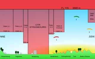
Français : Coupe verticale dans la direction NNE-SSW de l'espace aérien alsacien en 2009. En rouge : les espaces aérien controlés (CTR, TMA) dont l'acces nécessite l'autorisation de la tour de controle et la possession d'une radio aéronautique. Entre le sol et la base de l'espace aérien controlé, le vol libre est possible.
English: Vertical NNE-SSW cut of the alsatian airspace. In red : controlled airspace (CTR,TMA), no access without air traffic control autorisation. Between the ground level and the lower boundary of the controlled airspace, paragliding is allowed. |
| Date | |
| Source | Own work |
| Author | PiRK |
This W3C-unspecified vector image was created with Inkscape .
Licensing[edit]
I, the copyright holder of this work, hereby publish it under the following licenses:
This file is licensed under the Creative Commons Attribution-Share Alike 3.0 Unported license.
- You are free:
- to share – to copy, distribute and transmit the work
- to remix – to adapt the work
- Under the following conditions:
- attribution – You must give appropriate credit, provide a link to the license, and indicate if changes were made. You may do so in any reasonable manner, but not in any way that suggests the licensor endorses you or your use.
- share alike – If you remix, transform, or build upon the material, you must distribute your contributions under the same or compatible license as the original.

|
Permission is granted to copy, distribute and/or modify this document under the terms of the GNU Free Documentation License, Version 1.2 or any later version published by the Free Software Foundation; with no Invariant Sections, no Front-Cover Texts, and no Back-Cover Texts. A copy of the license is included in the section entitled GNU Free Documentation License. |
You may select the license of your choice.
File history
Click on a date/time to view the file as it appeared at that time.
| Date/Time | Thumbnail | Dimensions | User | Comment | |
|---|---|---|---|---|---|
| current | 23:29, 5 August 2009 | | 1,610 × 997 (249 KB) | PiRK (talk | contribs) | wrong file uploaded, the previous version should be deleted |
| 23:23, 5 August 2009 |  | 1,611 × 997 (318 KB) | PiRK (talk | contribs) | TMA 5&6 de Bale-Mulhouse au sud du ballon d'Alsace, lever de soleil | |
| 17:31, 30 July 2009 |  | 1,611 × 997 (69 KB) | PiRK (talk | contribs) | Probleme de rectangle noir resolu : [http://fr.wikipedia.org/wiki/Wikip%C3%A9dia:Atelier_graphique/FAQ_SVG#Un_carr.C3.A9_noir_est_visible_sur_l.27image Atelier Graphique/FAQ SVG] | |
| 05:29, 30 July 2009 |  | 1,611 × 997 (70 KB) | PiRK (talk | contribs) | wtf is that black rectangle | |
| 05:17, 30 July 2009 |  | 1,611 × 997 (68 KB) | PiRK (talk | contribs) | previous version seems corrupted (text with different sizes, black square) | |
| 05:10, 30 July 2009 |  | 1,611 × 997 (65 KB) | PiRK (talk | contribs) | {{Information |Description={{fr|1=Coupe verticale dans la direction NNE-SSW de l'espace aérien alsacien. En rouge : les espaces aérien controlés (CTR, TMA) dont l'acces nécessite l'autorisation de la tour de controle et la possession d'une radio aéro |
You cannot overwrite this file.
File usage on Commons
The following page uses this file:
File usage on other wikis
The following other wikis use this file:
- Usage on fr.wikipedia.org