File:Eruption Holuhraun sketch.png
Jump to navigation
Jump to search

Size of this preview: 800 × 585 pixels. Other resolutions: 320 × 234 pixels | 640 × 468 pixels | 1,024 × 749 pixels | 1,324 × 968 pixels.
Original file (1,324 × 968 pixels, file size: 3.67 MB, MIME type: image/png)
Captions
Captions
Add a one-line explanation of what this file represents
Summary[edit]
| Description |
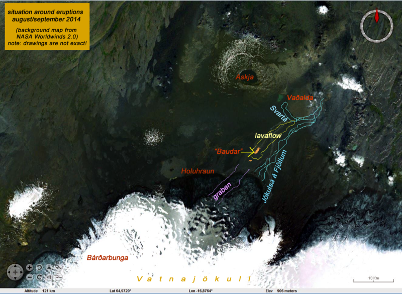
English: Sketch from Holuhraun lavafield and Bárđarbunga volcano, based on NASA Worldwinds 2.0 picture, derived 20 september 2014 |
| Date | |
| Source | Own work |
| Author | Tjako |
Licensing[edit]
I, the copyright holder of this work, hereby publish it under the following license:
This file is licensed under the Creative Commons Attribution-Share Alike 4.0 International license.
- You are free:
- to share – to copy, distribute and transmit the work
- to remix – to adapt the work
- Under the following conditions:
- attribution – You must give appropriate credit, provide a link to the license, and indicate if changes were made. You may do so in any reasonable manner, but not in any way that suggests the licensor endorses you or your use.
- share alike – If you remix, transform, or build upon the material, you must distribute your contributions under the same or compatible license as the original.
File history
Click on a date/time to view the file as it appeared at that time.
| Date/Time | Thumbnail | Dimensions | User | Comment | |
|---|---|---|---|---|---|
| current | 22:31, 20 September 2014 | | 1,324 × 968 (3.67 MB) | Tjako (talk | contribs) | User created page with UploadWizard |
You cannot overwrite this file.
File usage on Commons
The following page uses this file:
File usage on other wikis
The following other wikis use this file:
- Usage on nl.wikipedia.org
Metadata
Categories:
- Volcanology in Iceland
- Maps of Iceland
- Maps of Holuhraun
- Bárðarbunga in 2014
- Grabens (geology)
- Maps of volcanic eruptions
- 2014 eruptions in Iceland
- Jökulsá á Fjöllum
- Maps of fissure eruptions
- Grabens (geology) in Iceland
- Jökulsá á Fjöllum in 2014
- Maps of Askja
- Bárðarbunga-Veiðivötn volcanic system in 2014
- Calderas of the Askja volcanic system
- Volcano-tectonic episodes in Iceland
- East Volcanic Zone in 2014
- North Volcanic Zone in 2014
- Nested calderas of Askja
- Volcanological maps of Iceland
- Subglacial eruptions in 2014
- Askja (volcanic system) in 2014
- Maps of Bárðarbunga
- Askja (central volcano)