File:EricTheRedsLand.svg
Jump to navigation
Jump to search

Size of this PNG preview of this SVG file: 424 × 599 pixels. Other resolutions: 170 × 240 pixels | 340 × 480 pixels | 543 × 768 pixels | 724 × 1,024 pixels | 1,449 × 2,048 pixels | 1,181 × 1,669 pixels.
Original file (SVG file, nominally 1,181 × 1,669 pixels, file size: 813 KB)
Captions
Captions
Add a one-line explanation of what this file represents
Summary[edit]
| Description |
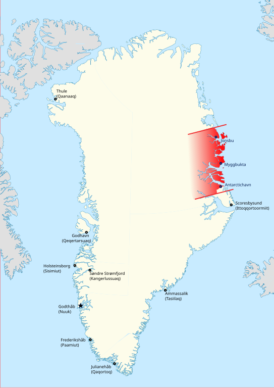
Français : Terre d’Erik le Rouge - occupation norvégienne de 1931 à 1933
English: Extension of the part of Greenland occupied by Norway in 1931 - 1933. |
| Date | |
| Source | file:Greenland edcp location map.svg |
| Author | Uwe Dedering |
Licensing[edit]
This file is licensed under the Creative Commons Attribution-Share Alike 3.0 Unported license.
- You are free:
- to share – to copy, distribute and transmit the work
- to remix – to adapt the work
- Under the following conditions:
- attribution – You must give appropriate credit, provide a link to the license, and indicate if changes were made. You may do so in any reasonable manner, but not in any way that suggests the licensor endorses you or your use.
- share alike – If you remix, transform, or build upon the material, you must distribute your contributions under the same or compatible license as the original.
File history
Click on a date/time to view the file as it appeared at that time.
| Date/Time | Thumbnail | Dimensions | User | Comment | |
|---|---|---|---|---|---|
| current | 14:25, 23 August 2019 | | 1,181 × 1,669 (813 KB) | Xfigpower (talk | contribs) | User created page with UploadWizard |
You cannot overwrite this file.
File usage on Commons
The following 4 pages use this file:
File usage on other wikis
The following other wikis use this file:
- Usage on ca.wikipedia.org
- Usage on cs.wikipedia.org
- Usage on de.wikipedia.org
- Usage on el.wikipedia.org
- Usage on en.wikipedia.org
- Usage on es.wikipedia.org
- Usage on et.wikipedia.org
- Usage on fr.wikipedia.org
- Usage on id.wikipedia.org
- Usage on nn.wikipedia.org
- Usage on no.wikipedia.org
- Usage on uk.wikipedia.org
- Usage on www.wikidata.org