File:Entrance to The Barons' Cave - geograph.org.uk - 1091358.jpg
Jump to navigation
Jump to search
No higher resolution available.
Entrance_to_The_Barons'_Cave_-_geograph.org.uk_-_1091358.jpg (640 × 426 pixels, file size: 136 KB, MIME type: image/jpeg)
Captions
Captions
Add a one-line explanation of what this file represents
Summary[edit]
| Description |
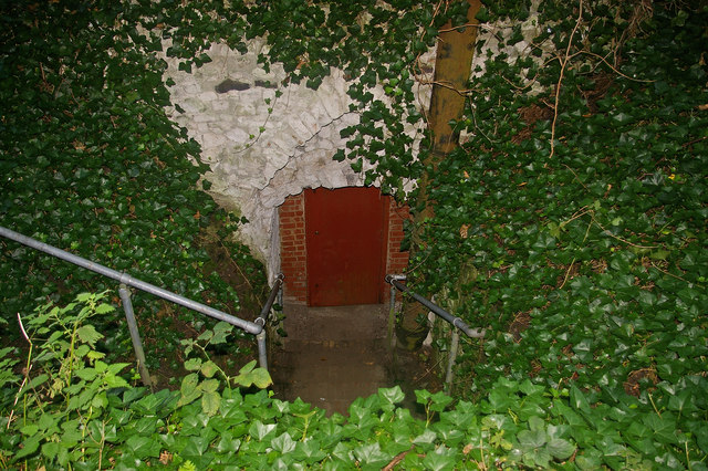
English: Entrance to The Barons' Cave. Lower entrance to the cave, which is the access point on the four or so days a year when it is open to the public. The cave is under the site of the former Reigate Castle, and there are a number of theories about its purpose, ranging from simply being the castle cellars through to being an escape route or a refuge. The reason for the name is that for many years the story was that this was the meeting point of the barons prior to meeting King John at Runnymede for the sealing of the Magna Carta, although this story has now been discredited. However, it added a bit of interest to the place, and perhaps explains why it has been a visitor's attraction, on and off, for many years, with references back to the 17th century and regular visits likely to have been made from the second half of the 18th century.
For further information see http://www.wcms.org.uk/pages/club/barons_cave.shtml, with further information available in the booklet "The Barons' Cave" by Peter Burgess, published by the Wealden Cave and Mine Society. Information and photos also at http://www.subbrit.org.uk/sb-sites/sites/b/barons/index.shtml. The stone surround to the entrance, in Reigate stone, probably dates from the mid nineteenth century when this entrance was restored, having previously been blocked for many years - prior to this the main access would have been the upper entrance - see 1091361. The iron pipe to the right of the door was installed in the 1940s to improve ventilation to the old sand mines which extended from below the cave though to under London Road, which were filled in in the 1980s due to concern of the risk of collapse. |
| Date | |
| Source | From geograph.org.uk |
| Author | Ian Capper |
| Attribution (required by the license) | Ian Capper / Entrance to The Barons' Cave / |
| Camera location | | View this and other nearby images on: OpenStreetMap |
|---|
_heading:67.00&language=en)
| Object location | | View this and other nearby images on: OpenStreetMap |
|---|
_heading:67.00&language=en)
Licensing[edit]

|
This image was taken from the Geograph project collection. See this photograph's page on the Geograph website for the photographer's contact details. The copyright on this image is owned by Ian Capper and is licensed for reuse under the Creative Commons Attribution-ShareAlike 2.0 license.
|
This file is licensed under the Creative Commons Attribution-Share Alike 2.0 Generic license.
Attribution: Ian Capper
- You are free:
- to share – to copy, distribute and transmit the work
- to remix – to adapt the work
- Under the following conditions:
- attribution – You must give appropriate credit, provide a link to the license, and indicate if changes were made. You may do so in any reasonable manner, but not in any way that suggests the licensor endorses you or your use.
- share alike – If you remix, transform, or build upon the material, you must distribute your contributions under the same or compatible license as the original.
File history
Click on a date/time to view the file as it appeared at that time.
| Date/Time | Thumbnail | Dimensions | User | Comment | |
|---|---|---|---|---|---|
| current | 14:03, 24 February 2011 | | 640 × 426 (136 KB) | GeographBot (talk | contribs) | == {{int:filedesc}} == {{Information |description={{en|1=Entrance to The Barons' Cave Lower entrance to the cave, which is the access point on the four or so days a year when it is open to the public. The cave is under the site of the former Reigate Cast |
You cannot overwrite this file.
File usage on Commons
There are no pages that use this file.