File:Engraving on a mammoth tusk, map, Gravettian, 076872 cropped.jpg
Jump to navigation
Jump to search

Size of this preview: 800 × 450 pixels. Other resolutions: 320 × 180 pixels | 640 × 360 pixels | 1,024 × 576 pixels | 1,280 × 720 pixels | 3,105 × 1,747 pixels.
Original file (3,105 × 1,747 pixels, file size: 1.79 MB, MIME type: image/jpeg)
Captions
Captions
Add a one-line explanation of what this file represents
Summary
[edit]
| Description |
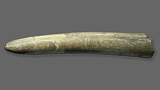
English: Engraving on a mammoth tusk perhaps representing a “map”, Pavlov (Břeclav DIstrict, Southern Moravia, Chech Republic), deposited in ArÚ AVČR Brno. Gravettian. Original. Length 37 cm. Temporary exhibition the Mammoth hunters in the NM Prague. The Pavlovské Hills were created by the arches at top right. In the foothills, the Pavlov settlement appears to have been marked by a circle, while a wavy pattern at the bottom is thought to have symbolized the meanders of the River Dyje. This engraving may well be the oldest known representation of a landscape. Excavation under B. Klíma.
Deutsch: Die 1962 gefundene abgebrochene Spitze eines Mammut-Stoßzahns ist mit einer Gravur versehen, bei der es sich um eine Abbildung der umgebenden Landschaft des Jägerlagers Pavlov I handeln könnte. Die vier verschiedenen Muster dieser stilisierten „ersten Landkarte“ können z. B. als Erosionsrinnen der Pollauer Berge und mäandrierender Flusslauf der Thaya interpretiert werden, der Lagerplatz selbst ist möglicherweise durch zwei konzentrische Kreise dargestellt. |
| Date | |
| Source | File:Engraving_on_a_mammoth_tusk,_map,_Gravettian,_076872.jpg |
| Author | User:Zde |
| Other versions |
 |
Licensing
[edit]
I, the copyright holder of this work, hereby publish it under the following license:
This file is licensed under the Creative Commons Attribution-Share Alike 4.0 International license.
- You are free:
- to share – to copy, distribute and transmit the work
- to remix – to adapt the work
- Under the following conditions:
- attribution – You must give appropriate credit, provide a link to the license, and indicate if changes were made. You may do so in any reasonable manner, but not in any way that suggests the licensor endorses you or your use.
- share alike – If you remix, transform, or build upon the material, you must distribute your contributions under the same or compatible license as the original.
File history
Click on a date/time to view the file as it appeared at that time.
| Date/Time | Thumbnail | Dimensions | User | Comment | |
|---|---|---|---|---|---|
| current | 08:28, 23 June 2019 | | 3,105 × 1,747 (1.79 MB) | Thilo Parg (talk | contribs) | {{Information |description ={{en|1=Engraving on a mammoth tusk perhaps representing a “map”, Pavlov (Břeclav DIstrict, Southern Moravia, Chech Republic), deposited in ArÚ AVČR Brno. Gravettian. Original. Length 37 cm. Temporary exhibition the Mammoth hunters in the NM Prague. The Pavlovské Hills were created by the arches at top right. In the foothills, the Pavlov settlement appears to have been marked by a circle, while a wavy pattern at the bottom is thought to have symbolized the meander... |
You cannot overwrite this file.
File usage on Commons
There are no pages that use this file.
File usage on other wikis
The following other wikis use this file:
- Usage on de.wikipedia.org
- Usage on en.wikipedia.org
- Usage on fr.wikipedia.org