File:EnglandAvon.svg
Jump to navigation
Jump to search

Size of this PNG preview of this SVG file: 200 × 247 pixels. Other resolutions: 194 × 240 pixels | 389 × 480 pixels | 622 × 768 pixels | 829 × 1,024 pixels | 1,658 × 2,048 pixels.
Original file (SVG file, nominally 200 × 247 pixels, file size: 189 KB)
Captions
Captions
Add a one-line explanation of what this file represents
Summary[edit]
| Description |
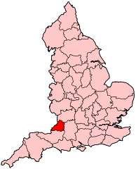
English: Avon shown within England. Map is valid from 1 April 1974 to 1 April 1996. |
| Source | Own work |
| Author | Wereon |
Licensing[edit]
| I, the copyright holder of this work, release this work into the public domain. This applies worldwide. In some countries this may not be legally possible; if so: I grant anyone the right to use this work for any purpose, without any conditions, unless such conditions are required by law. |
File history
Click on a date/time to view the file as it appeared at that time.
| Date/Time | Thumbnail | Dimensions | User | Comment | |
|---|---|---|---|---|---|
| current | 23:20, 26 April 2007 | | 200 × 247 (189 KB) | Wereon (talk | contribs) | Map of the former English administrative county of Avon. Category:Maps of English counties |
You cannot overwrite this file.
File usage on Commons
The following page uses this file:
File usage on other wikis
The following other wikis use this file:
- Usage on ca.wikipedia.org
- Usage on cy.wikipedia.org
- Thornbury a Yate (etholaeth seneddol)
- Filton a Bradley Stoke (etholaeth seneddol)
- De Bryste (etholaeth seneddol)
- Dwyrain Bryste (etholaeth seneddol)
- Gorllewin Bryste (etholaeth seneddol)
- Gogledd-orllewin Bryste (etholaeth seneddol)
- Kingswood (etholaeth seneddol)
- Weston-super-Mare (etholaeth seneddol)
- Gogledd Gwlad yr Haf (etholaeth seneddol)
- Gogledd-ddwyrain Gwlad yr Haf (etholaeth seneddol)
- Usage on de.wikipedia.org
- Usage on en.wikipedia.org
- Avon (county)
- Bristol West (UK Parliament constituency)
- Bristol North West (UK Parliament constituency)
- Kingswood (UK Parliament constituency)
- Northavon (UK Parliament constituency)
- Wansdyke (UK Parliament constituency)
- Woodspring (UK Parliament constituency)
- Bristol East (UK Parliament constituency)
- Filton and Bradley Stoke (UK Parliament constituency)
- Thornbury and Yate (UK Parliament constituency)
- Parliamentary constituencies in South West England
- Usage on eo.wikipedia.org
- Usage on es.wikipedia.org
- Usage on eu.wikipedia.org
- Usage on fr.wikipedia.org
- Comté d'Avon
- Bristol East
- Bristol North West
- Bristol South (circonscription du Parlement britannique)
- Bristol West (circonscription du Parlement britannique)
- Filton and Bradley Stoke
- Kingswood (circonscription britannique)
- Weston-super-Mare (circonscription britannique)
- Yeovil (circonscription britannique)
- Usage on it.wikipedia.org
- Usage on mr.wikipedia.org
- Usage on pl.wikipedia.org
- Usage on pt.wikipedia.org
- Usage on ru.wikipedia.org
- Usage on sv.wikipedia.org
- Usage on uk.wikipedia.org
- Usage on ur.wikipedia.org
- Usage on www.wikidata.org
- Usage on zh.wikipedia.org