File:EngelbergSO.jpg
Jump to navigation
Jump to search

Size of this preview: 800 × 450 pixels. Other resolutions: 320 × 180 pixels | 640 × 360 pixels | 1,024 × 576 pixels | 1,280 × 720 pixels | 2,560 × 1,440 pixels | 6,000 × 3,376 pixels.
Original file (6,000 × 3,376 pixels, file size: 3.82 MB, MIME type: image/jpeg)
Captions
Captions
Add a one-line explanation of what this file represents
Summary[edit]
![]() Switzerland
Switzerland ![]() Obwalden
Obwalden ![]() Engelberg - Urner Alpen 1.005 m ü.M.
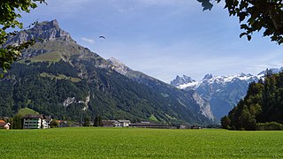
Engelberg - Urner Alpen 1.005 m ü.M.
| Description |
Deutsch: Vom Bänklialpweg schauen wir ins hintere Tal der Engelberger Aa über Wyden und die Fürenalp zum Gross Spannort 3.198 m & Chli Spannort 3.140 m. |
| Date | Taken on 21 September 2013, 13:29:45 |
| Source | Own work |
| Author | FkMohr |
| Camera location | | View this and other nearby images on: OpenStreetMap |
|---|
OW {XF130921-1329} übertragen von Panoramio (User Mohr=1080936, Bild 99086642).
Licensing[edit]
Friedrich-Karl Mohr, the copyright holder of this work, hereby publishes it under the following license:
This file is licensed under the Creative Commons Attribution-Share Alike 3.0 Germany license.
Attribution: Friedrich-Karl Mohr
- You are free:
- to share – to copy, distribute and transmit the work
- to remix – to adapt the work
- Under the following conditions:
- attribution – You must give appropriate credit, provide a link to the license, and indicate if changes were made. You may do so in any reasonable manner, but not in any way that suggests the licensor endorses you or your use.
- share alike – If you remix, transform, or build upon the material, you must distribute your contributions under the same or compatible license as the original.

File history
Click on a date/time to view the file as it appeared at that time.
| Date/Time | Thumbnail | Dimensions | User | Comment | |
|---|---|---|---|---|---|
| current | 17:10, 13 September 2017 | | 6,000 × 3,376 (3.82 MB) | FkMohr (talk | contribs) | Transferred from http://static.panoramio.com/photos/original/99086642.jpg |
You cannot overwrite this file.
File usage on Commons
The following 24 pages use this file:
- Obwalden
- User:Mattes/Contributions/Gallery of data/108
- Category:Births in the canton of Obwalden
- Category:Buildings in the canton of Obwalden
- Category:Canton of Obwalden
- Category:Cultural properties of national significance in the canton of Obwalden
- Category:Culture of the canton of Obwalden
- Category:Deaths in the canton of Obwalden
- Category:Geography of the canton of Obwalden
- Category:Infrastructure in the canton of Obwalden
- Category:Lakes in the canton of Obwalden
- Category:Landammann (Obwalden)
- Category:Landforms of the canton of Obwalden
- Category:Monuments and memorials in the canton of Obwalden
- Category:Mountain passes in the canton of Obwalden
- Category:Municipalities in the canton of Obwalden
- Category:Museums in the canton of Obwalden
- Category:People of the canton of Obwalden
- Category:Railway stations in the canton of Obwalden
- Category:Religion in the canton of Obwalden
- Category:Rivers in the canton of Obwalden
- Category:Sports in the canton of Obwalden
- Category:Transport in the canton of Obwalden
- Category:Valleys of the canton of Obwalden
File usage on other wikis
The following other wikis use this file:
- Usage on ar.wikipedia.org
- Usage on ast.wikipedia.org
- Usage on az.wikipedia.org
- Usage on be.wikipedia.org
- Usage on ca.wikipedia.org
- Usage on ceb.wikipedia.org
- Usage on cs.wikipedia.org
- Usage on cy.wikipedia.org
- Usage on de.wikipedia.org
- Usage on de.wikivoyage.org
- Usage on es.wikipedia.org
- Usage on eu.wikipedia.org
- Usage on gl.wikipedia.org
- Usage on he.wikipedia.org
- Usage on hy.wikipedia.org
- Usage on ilo.wikipedia.org
- Usage on ka.wikipedia.org
- Usage on ku.wikipedia.org
- Usage on lld.wikipedia.org
- Usage on lmo.wikipedia.org
- Usage on mzn.wikipedia.org
- Usage on no.wikipedia.org
- Usage on oc.wikipedia.org
- Usage on pl.wikipedia.org
- Usage on ps.wikipedia.org
- Usage on ro.wikipedia.org
- Usage on ru.wikipedia.org
- Usage on sr.wikipedia.org
- Usage on uk.wikipedia.org
- Usage on vec.wikipedia.org
- Usage on vi.wikipedia.org
- Usage on www.wikidata.org