File:Enabling bridge, Droitwich Junction Canal - geograph.org.uk - 909309.jpg
Jump to navigation
Jump to search
No higher resolution available.
Enabling_bridge,_Droitwich_Junction_Canal_-_geograph.org.uk_-_909309.jpg (640 × 480 pixels, file size: 145 KB, MIME type: image/jpeg)
Captions
Captions
Add a one-line explanation of what this file represents
Summary[edit]
| Description |
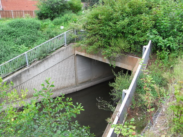
English: Enabling bridge, Droitwich Junction Canal This is 50 yards from the tunnel under the M5 and carries a new(ish) road. It was obviously built to accommodate the canal when it is restored (work in hot progress) and as such is an enabling work and indicates forward planning (like the dry aqueduct over the M6 Toll). The water flowing at the moment is a stream that joins the Salwarpe. Work has clearly started on the Hanbury side of the M5 but is not accessible. |
| Date | |
| Source | From geograph.org.uk |
| Author | Chris Allen |
| Attribution (required by the license) | Chris Allen / Enabling bridge, Droitwich Junction Canal / |
| Camera location | | View this and other nearby images on: OpenStreetMap |
|---|
_heading:292.00&language=en)
| Object location | | View this and other nearby images on: OpenStreetMap |
|---|
_heading:292.00&language=en)
Licensing[edit]

|
This image was taken from the Geograph project collection. See this photograph's page on the Geograph website for the photographer's contact details. The copyright on this image is owned by Chris Allen and is licensed for reuse under the Creative Commons Attribution-ShareAlike 2.0 license.
|
This file is licensed under the Creative Commons Attribution-Share Alike 2.0 Generic license.
Attribution: Chris Allen
- You are free:
- to share – to copy, distribute and transmit the work
- to remix – to adapt the work
- Under the following conditions:
- attribution – You must give appropriate credit, provide a link to the license, and indicate if changes were made. You may do so in any reasonable manner, but not in any way that suggests the licensor endorses you or your use.
- share alike – If you remix, transform, or build upon the material, you must distribute your contributions under the same or compatible license as the original.
File history
Click on a date/time to view the file as it appeared at that time.
| Date/Time | Thumbnail | Dimensions | User | Comment | |
|---|---|---|---|---|---|
| current | 19:21, 21 February 2011 | | 640 × 480 (145 KB) | GeographBot (talk | contribs) | == {{int:filedesc}} == {{Information |description={{en|1=Enabling bridge, Droitwich Junction Canal This is 50 yards from the tunnel under the M5 and carries a new(ish) road. It was obviously built to accommodate the canal when it is restored (work in hot |
You cannot overwrite this file.
File usage on Commons
There are no pages that use this file.