File:Elwha River, Washington.jpg
Jump to navigation
Jump to search

Size of this preview: 653 × 600 pixels. Other resolutions: 261 × 240 pixels | 523 × 480 pixels | 808 × 742 pixels.
Original file (808 × 742 pixels, file size: 134 KB, MIME type: image/jpeg)
Captions
Captions
Add a one-line explanation of what this file represents
Summary
[edit]
| Description |
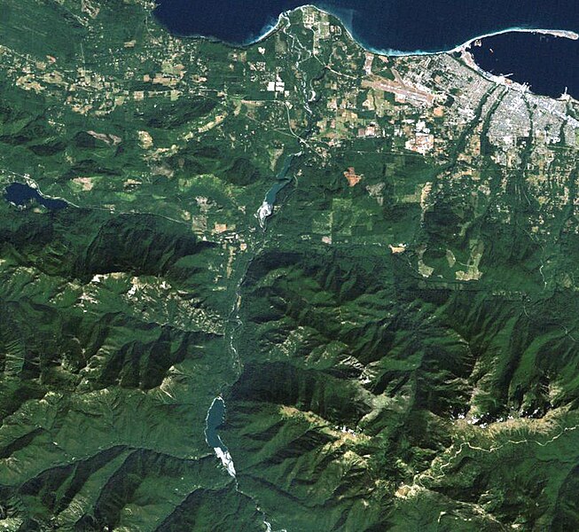
English: Two of the reservoirs in this Landsat 5 image, Lake Aldwell to the north and Lake Mills to the south, are relatively short-lived. This month, the long process of removing the Elwha and Glines Canyon dams begins.
Image date: September 7, 2011 Satellite: Landsat 5 Path 47, Row 27 For more information: pubs.usgs.gov/fs/2011/3097/ pubs.usgs.gov/sir/2011/5120/ Full scenes can be found at: glovis.usgs.gov earthexplorer.usgs.gov |
| Date | |
| Source | https://www.flickr.com/photos/67262084@N07/6143998991/ |
| Author | USGS Landsat |
| Camera location | | View this and other nearby images on: OpenStreetMap |
|---|
Licensing
[edit]
This file is licensed under the Creative Commons Attribution 2.0 Generic license.
- You are free:
- to share – to copy, distribute and transmit the work
- to remix – to adapt the work
- Under the following conditions:
- attribution – You must give appropriate credit, provide a link to the license, and indicate if changes were made. You may do so in any reasonable manner, but not in any way that suggests the licensor endorses you or your use.
| This image was originally posted to Flickr by USGS Landsat at https://flickr.com/photos/67262084@N07/6143998991. It was reviewed on 27 October 2020 by FlickreviewR 2 and was confirmed to be licensed under the terms of the cc-by-2.0. |
| Annotations | This image is annotated: View the annotations at Commons |
File history
Click on a date/time to view the file as it appeared at that time.
| Date/Time | Thumbnail | Dimensions | User | Comment | |
|---|---|---|---|---|---|
| current | 16:53, 27 October 2020 | | 808 × 742 (134 KB) | Kroger4 (talk | contribs) | Uploaded a work by USGS Landsat from https://www.flickr.com/photos/67262084@N07/6143998991/ with UploadWizard |
You cannot overwrite this file.
File usage on Commons
There are no pages that use this file.