File:Elevations.png

From Wikimedia Commons, the free media repository
Jump to navigation Jump to search

Original file(544 × 602 pixels, file size: 15 KB, MIME type: image/png)

Captions

Captions

Add a one-line explanation of what this file represents

Summary[edit]

Description
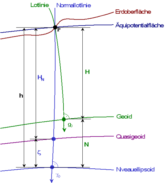
Deutsch: Schematische Darstellung verschiedener geodätischer Höhensysteme.
Äquipotentialfläche: Eine von unendlich vielen Äquipotentialflächen im Schwerefeld der Erde, hier jene, die durch den Punkt P auf der Erdoberfläche verläuft. „Äquipotentialfläche“ heißt: Punkt P hat das das gleiche Schwerepotential wie jeder beliebige andere Punkt auf dieser Fläche.
Geoid: Äquipotentialfläche auf mittlerer Meereshöhe (entsprechender Bezugspunkt nicht dargestellt), die als physikalische Bezugsfläche fungiert.
Niveauellipsoid: Referenzellipsoid im Normalhöhensystem. Der Referenzellipsoid ist ein geometrischer Körper (Rotationsellipsoid), eine mathematische Näherung des Erdkörpers („mathematische Erdfigur“), dessen Oberfläche als geometrische Bezugsfläche fungiert. In globalem Maßstab ist dies beispielsweise das WGS84. Im Normalhöhensystem ist jedoch die Oberfläche des Niveauellipsoids eine Äquipotentialfläche des Normalschwerefeldes, einer Näherung des realen Schwerefeldes der Erde, das der Ellipsoid selbst erzeugt. Ein entsprechendes globales Referenzsystem ist GRS80.
Quasigeoid: geometrische Bezugsfläche im Normalhöhensysten, die definiert ist durch die Höhenanomalie ζ als ellipsoidische Höhe über dem Niveauellipsoid.
Lotlinie: Linie durch P die senkrecht auf allen Äquipotentialflächen steht
Normallotlinie (Ellipsoidnormale): Linie durch P die senkrecht auf dem Niveauellipsoiden steht
g0: Schwere (Fallbeschleunigung) entlang der Lotlinie
γ0: Normalschwere entlang der Normallotlinie
h: ellipsoidische Höhe von P
H: orthometrische Höhe von P (Quotient aus der geopotentiellen Kote, d.h. der Potentialdifferenz zwischen P und dem Schnittpunkt der Lotlinie durch P mit dem Geoid, und der mittleren Schwere zwischen beiden Punkten entlang der Lotlinie).
HN: Normalhöhe von P (Berechnung analog zur orthometrischen Höhe, wobei das Schwerepotential des Niveauellipsoiden dem des Geoids gleichgesetzt wird. Divisor ist die mittlere Normalschwere entlang der Normallotlinie, die sich aus dem Schwerefeld des Niveauellipsoids ergibt.)
ζ: Höhenanomalie im Normalhöhensystem. Sie ergibt sich bei der Berechnung der Normalhöhe und bildet die Differenz zwischen der ellipsoidischen Höhe von P und der Normalhöhe von P.
N: Geoidundulation. Sie ergibt sich aus der Differenz zwischen der ellipsoidischen Höhe von P und der orthometrischen Höhe von P.
English: different definitions of elevation (German version)
Date
Source Own work
Author J. Mondzech

Licensing[edit]

GNU head Permission is granted to copy, distribute and/or modify this document under the terms of the GNU Free Documentation License, Version 1.2 or any later version published by the Free Software Foundation; with no Invariant Sections, no Front-Cover Texts, and no Back-Cover Texts. A copy of the license is included in the section entitled GNU Free Documentation License.
w:en:Creative Commons
attribution share alike
This file is licensed under the Creative Commons Attribution-Share Alike 3.0 Unported license.
You are free:
  • to share – to copy, distribute and transmit the work
  • to remix – to adapt the work
Under the following conditions:
  • attribution – You must give appropriate credit, provide a link to the license, and indicate if changes were made. You may do so in any reasonable manner, but not in any way that suggests the licensor endorses you or your use.
  • share alike – If you remix, transform, or build upon the material, you must distribute your contributions under the same or compatible license as the original.
This licensing tag was added to this file as part of the GFDL licensing update.


This diagram image could be re-created using vector graphics as an SVG file. This has several advantages; see Commons:Media for cleanup for more information. If an SVG form of this image is available, please upload it and afterwards replace this template with {{vector version available|new image name}}.


It is recommended to name the SVG file “Elevations.svg”—then the template Vector version available (or Vva) does not need the new image name parameter.

File history

Click on a date/time to view the file as it appeared at that time.

Date/TimeThumbnailDimensionsUserComment
current17:40, 10 September 2006Thumbnail for version as of 17:40, 10 September 2006544 × 602 (15 KB)Langläufer (talk | contribs){{Information |Description=different definitons of elevation |Source= |Date=09. Sep 2006 |Author= J. Mondzech |Permission= |other_versions= }} {{Information |Description=Die verschiedenen Höhendefinitionen |Source= |Date=09. Sep 2006 |Author= J. Mondze

There are no pages that use this file.

File usage on other wikis

The following other wikis use this file: