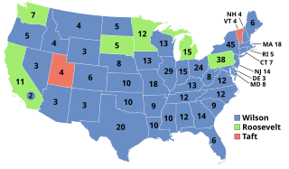
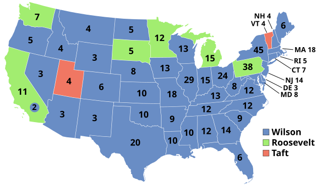
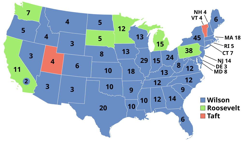
File:ElectoralCollege1912.svg

Original file (SVG file, nominally 1,020 × 593 pixels, file size: 25 KB)
Captions
Captions
| U.S. presidential election maps (SVG) |
| See also: National Atlas maps (png) |
|
1789 · 1792 · 1796 · 1800 · 1804 · 1808 · 1812 · 1816 · 1820 · 1824 · 1828 · 1832 · 1836 · 1840 · 1844 · 1848 · 1852 · 1856 · 1860 · 1864 · 1868 · 1872 · 1876 · 1880 · 1884 · 1888 · 1892 · 1896 · 1900 · 1904 · 1908 · 1912 · 1916 · 1920 · 1924 · 1928 · 1932 · 1936 · 1940 · 1944 · 1948 · 1952 · 1956 · 1960 · 1964 · 1968 · 1972 · 1976 · 1980 · 1984 · 1988 · 1992 · 1996 · 2000 · 2004 · 2008 · 2012 · 2016 · 2020 · 2024 |
Summary[edit]
| Description | |
| Date | |
| Source | |
| Author | Nakor |
Licensing[edit]
| I, the copyright holder of this work, release this work into the public domain. This applies worldwide. In some countries this may not be legally possible; if so: I grant anyone the right to use this work for any purpose, without any conditions, unless such conditions are required by law. |
Original upload log[edit]
This image is a derivative work of the following images:
- ElectoralCollege2008.svg licensed with PD-self
- 2008-11-19T21:33:53Z Bouchecl 1020x593 (122263 Bytes) {{Information |Description=Electoral Map updated with MO results - State was called for McCain on 11/19/2008 by 3 news orgs |Source= |Date= |Author= |Permission= |other_versions= }}
- 2008-11-17T03:01:11Z Timmeh 1020x593 (122264 Bytes) Reverted to version as of 05:27, 10 November 2008
- 2008-11-17T01:46:20Z Magog the Ogre 1020x593 (123131 Bytes) Missouri called for McCain by NBC; see explanation at en.wikipedia talkpage.
- 2008-11-10T05:27:18Z SteveSims 1020x593 (122264 Bytes) Those sites, like most, were simply not precise enough to split NE's electoral votes since they assumed all 5 would go to the same person. CNN and ABC didn't "call" NE's 2nd district for McCain. However, many absentee ballots
- 2008-11-10T04:51:35Z Gage 1020x593 (122264 Bytes) ABC and CNN have projected Nebraska's 2nd district for McCain, according to Pollster.com. Electoral vote is still tossup.
- 2008-11-08T05:04:21Z Gage 1020x593 (122264 Bytes) {{Information |Description={{en|1=[[:en:Electoral College (United States)|Electoral college]] map for the [[:en:United States presidential election, 2008|2008 United States presidential election]] (note: Nebraska and Maine sp
- 1912 Electoral Map.png licensed with PD-USGov-Atlas
- 2008-06-25T22:27:01Z Tallicfan20 1182x635 (183653 Bytes)
- 2008-05-25T23:35:56Z Tallicfan20 1182x635 (152717 Bytes) distinguish the blue and green better, match bar under TR's face
- 2008-05-25T04:50:10Z Tallicfan20 1182x635 (153430 Bytes) better color
- 2008-05-17T04:55:06Z Tallicfan20 1182x635 (105769 Bytes) {{PD-USGov-Atlas}}
Uploaded with derivativeFX
File history
Click on a date/time to view the file as it appeared at that time.
| Date/Time | Thumbnail | Dimensions | User | Comment | |
|---|---|---|---|---|---|
| current | 05:40, 19 January 2023 | | 1,020 × 593 (25 KB) | Politicsfan4 (talk | contribs) | code, DC colors need to be fixed across multiple maps (will do that later) |
| 01:55, 30 November 2022 |  | 1,020 × 593 (83 KB) | Faustino Sojo (talk | contribs) | Reverted to version as of 07:39, 26 November 2022 (UTC) | |
| 07:41, 26 November 2022 |  | 512 × 298 (27 KB) | 沁水湾 (talk | contribs) | resize | |
| 07:39, 26 November 2022 |  | 1,020 × 593 (83 KB) | 沁水湾 (talk | contribs) | DC incorrectly colored in as blue | |
| 07:38, 26 November 2022 |  | 512 × 300 (27 KB) | 沁水湾 (talk | contribs) | DC incorrectly colored in as blue | |
| 15:18, 28 December 2018 |  | 1,020 × 593 (25 KB) | Newfraferz87 (talk | contribs) | Optimize | |
| 16:53, 15 April 2012 |  | 1,020 × 593 (83 KB) | Citypeek (talk | contribs) | alignment names | |
| 03:28, 7 January 2009 |  | 1,020 × 593 (104 KB) | Cg-realms (talk | contribs) | Uniform color for Progressive Party: a2ed70ff | |
| 15:10, 28 December 2008 |  | 1,020 × 593 (97 KB) | Nakor (talk | contribs) | {{Information |Description={{en|1=Electoral college map for the 2008 United States presidential election (note: Nebraska and Maine split their EVs by congressional |
You cannot overwrite this file.
File usage on Commons
The following 7 pages use this file:
- United States presidential election maps
- User:DaSch/Bot-Export
- User:Magog the Ogre/Political maps/2018 December 21-31
- User:Magog the Ogre/Political maps/2022 November 21-30
- User:Magog the Ogre/Political maps/2023 January 11-20
- File:1912 Electoral Map.png
- Category:United States presidential election, 1912
File usage on other wikis
The following other wikis use this file:
- Usage on da.wikipedia.org
- Usage on de.wikipedia.org
- Usage on el.wikipedia.org
- Usage on en.wikipedia.org
- Woodrow Wilson
- 1912 United States presidential election
- Electoral vote changes between United States presidential elections
- Presidency of Woodrow Wilson
- List of United States presidential election results by state
- Presidency of William Howard Taft
- 1912 United States presidential election in California
- United States presidential election
- 1912 United States presidential election in Pennsylvania
- 1912 United States presidential election in Montana
- Template:1912 United States presidential election imagemap
- 1912 United States presidential election in New Mexico
- 1912 United States presidential election in New York
- 1912 United States presidential election in Massachusetts
- Template:State results of the 1912 U.S. presidential election
- 1912 United States presidential election in Vermont
- User:1Matt20/sandbox
- 1912 United States presidential election in New Jersey
- 1912 United States elections
- 1912 United States presidential election in Virginia
- User:Tyche-pup/sandbox
- 1912 United States presidential election in Wisconsin
- 1912 United States presidential election in Minnesota
- 1912 United States presidential election in Nevada
- 1912 United States presidential election in New Hampshire
- 1912 United States presidential election in Ohio
- 1912 United States presidential election in Connecticut
- 1912 United States presidential election in Maine
- 1912 United States presidential election in Rhode Island
- 1912 United States presidential election in Florida
- 1912 United States presidential election in Utah
- 1912 United States presidential election in South Carolina
- 1912 United States presidential election in Wyoming
- 1912 United States presidential election in Texas
- 1912 United States presidential election in West Virginia
- 1912 United States presidential election in Washington (state)
- 1912 United States presidential election in South Dakota
- 1912 United States presidential election in Tennessee
- 1912 United States presidential election in Oregon
- 1912 United States presidential election in Oklahoma
- 1912 United States presidential election in North Dakota
- 1912 United States presidential election in North Carolina
- 1912 United States presidential election in Nebraska
- 1912 United States presidential election in Missouri
- 1912 United States presidential election in Mississippi
View more global usage of this file.