File:El Yunque Trails Map.png
(Redirected from File:El Yunque Trails Map.gif)
Size of this preview: 408 × 600 pixels. Other resolutions: 163 × 240 pixels | 585 × 860 pixels.
Original file (585 × 860 pixels, file size: 39 KB, MIME type: image/png)
Captions
Captions
Add a one-line explanation of what this file represents
Summary[edit]
| Description |
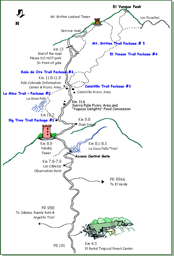
English: A map of trails and other locations along Puerto Rico Highway 191 in El Yunque National Forest, Puerto Rico. |
| Date | |
| Source | http://www.fs.fed.us/r8/caribbean/recreation/recreation_hiking.shtml |
| Author | USDA Forest Service |
Licensing[edit]
This work is in the public domain in the United States because it is a work prepared by an officer or employee of the United States Government as part of that person’s official duties under the terms of Title 17, Chapter 1, Section 105 of the US Code.
Note: This only applies to original works of the Federal Government and not to the work of any individual U.S. state, territory, commonwealth, county, municipality, or any other subdivision. This template also does not apply to postage stamp designs published by the United States Postal Service since 1978. (See § 313.6(C)(1) of Compendium of U.S. Copyright Office Practices). It also does not apply to certain US coins; see The US Mint Terms of Use.
|
 | |
| This file has been identified as being free of known restrictions under copyright law, including all related and neighboring rights. | ||
Original upload log[edit]
| Date/Time | Dimensions | User | Comment |
|---|---|---|---|
| 27 February 2011, 06:05:06 | 585 × 860 (34750 bytes) | AjaxSmack (talk · contribs) | {{Information |Description ={{en|1=A map of trails and other locations along [[:en:Puerto Rico Highway 191|Puerto Rico Highway 191]] in [[:en:El Yunque National Forest|El Yunque National Forest]], [[:en:Puerto Rico|Puerto Rico]].}} |Source =htt |
File history
Click on a date/time to view the file as it appeared at that time.
| Date/Time | Thumbnail | Dimensions | User | Comment | |
|---|---|---|---|---|---|
| current | 09:34, 8 January 2015 | | 585 × 860 (39 KB) | GifTagger (talk | contribs) | Bot: Converting file to superior PNG file. (Source: El_Yunque_Trails_Map.gif). This GIF was problematic due to transparency and non-greyscale color table. |
You cannot overwrite this file.
File usage on Commons
The following 3 pages use this file:
File usage on other wikis
The following other wikis use this file:
- Usage on en.wikipedia.org