File:Ei-map.svg
Jump to navigation
Jump to search

Size of this PNG preview of this SVG file: 517 × 599 pixels. Other resolutions: 207 × 240 pixels | 414 × 480 pixels | 662 × 768 pixels | 883 × 1,024 pixels | 1,766 × 2,048 pixels | 652 × 756 pixels.
Original file (SVG file, nominally 652 × 756 pixels, file size: 115 KB)
Captions
Captions
Add a one-line explanation of what this file represents
Summary[edit]
| Description |
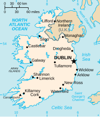
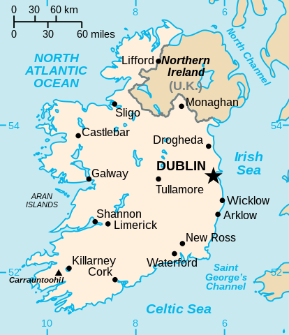
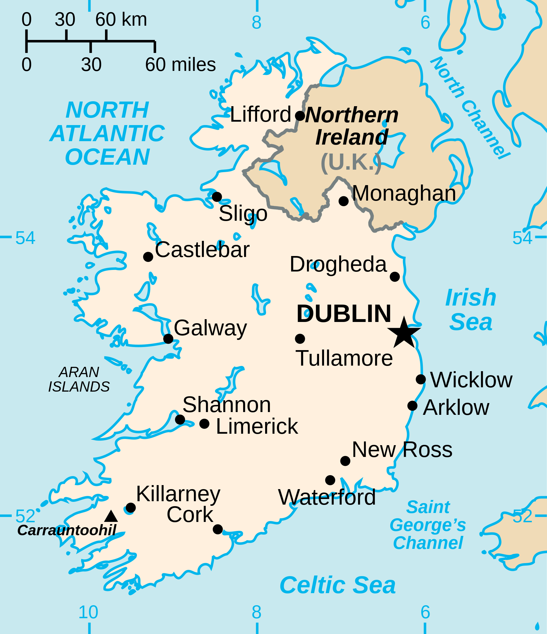
English: Vector version of CIA WorldBook map of the Republic of Ireland. Mercator projection. Vector information is from the CIA World DataBank II, and hence in the public domain. |
| Source |
This file was derived from: Ei-map.png |
| Author | CIA World Factbook |
| Other versions |
[]
|


.svg)


Licensing[edit]
| I, the copyright holder of this work, release this work into the public domain. This applies worldwide. In some countries this may not be legally possible; if so: I grant anyone the right to use this work for any purpose, without any conditions, unless such conditions are required by law. |
File history
Click on a date/time to view the file as it appeared at that time.
| Date/Time | Thumbnail | Dimensions | User | Comment | |
|---|---|---|---|---|---|
| current | 15:16, 24 December 2022 | | 652 × 756 (115 KB) | Wikijahnn (talk | contribs) | File uploaded using svgtranslate tool (https://svgtranslate.toolforge.org/). Added translation for ca. |
| 19:34, 3 September 2020 |  | 652 × 756 (110 KB) | Andrei Stroe (talk | contribs) | File uploaded using svgtranslate tool (https://svgtranslate.toolforge.org/). Added translation for ro. | |
| 22:16, 24 July 2006 |  | 652 × 756 (99 KB) | Wereon (talk | contribs) | Vector version of CIA WorldBook map of the Republic of Ireland. Mercator projection. Vector information is from the CIA World DataBank II, and hence in the public domain. |
You cannot overwrite this file.
File usage on Commons
The following 54 pages use this file:
- Atlas of Ireland
- Dublin / Baile Átha Cliath
- Republic of Ireland / Poblacht na hÉireann
- User:STyx/Project Mapmaking Wiki Standards
- File:Ei-map-it.svg
- File:Ei-map.png
- File:Ei-map.svg
- File:Ei-map (Lithuanian).svg
- File:Ei-map - 2.png
- File:Ei-map rus.svg
- File:Ei-map sr.svg
- File:Ireland-CIA WFB Map.png
- Template:Other versions/Ei-map
- Category:2000 in Dublin
- Category:Births in Dublin
- Category:Bridges in Dublin
- Category:Castles in Dublin
- Category:Companies based in Dublin (city)
- Category:Culture of Dublin
- Category:Deaths in Dublin
- Category:Dublin
- Category:Dublin in the 18th century
- Category:Dublin in the 1900s
- Category:Dublin in the 1910s
- Category:Dublin in the 1920s
- Category:Dublin in the 1930s
- Category:Dublin in the 1940s
- Category:Dublin in the 1950s
- Category:Dublin in the 1960s
- Category:Dublin in the 1970s
- Category:Dublin in the 1980s
- Category:Dublin in the 1990s
- Category:Dublin in the 19th century
- Category:Dublin in the 2000s
- Category:Dublin in the 2010s
- Category:Dublin in the 2020s
- Category:Dublin in the 20th century
- Category:Dublin in the 21st century
- Category:Events in Dublin
- Category:Geography of Dublin
- Category:Illuminated buildings in Dublin
- Category:Maps of Dublin
- Category:Museums in Dublin
- Category:Music events in Dublin
- Category:Music events in Naples
- Category:Organisations based in Dublin (city)
- Category:Pubs in Dublin
- Category:Railway stations in Dublin
- Category:Republic of Ireland
- Category:Rivers of Dublin
- Category:Ships named after Dublin
- Category:Sports in Dublin
- Category:Sports venues in Dublin
- Category:Visitor attractions in Dublin
File usage on other wikis
The following other wikis use this file:
- Usage on af.wikipedia.org
- Usage on af.wiktionary.org
- Usage on ang.wikipedia.org
- Usage on ar.wikipedia.org
- Usage on arz.wikipedia.org
- Usage on ast.wikipedia.org
- Usage on be-tarask.wikipedia.org
- Usage on be.wikipedia.org
- Usage on bg.wikipedia.org
- Usage on ca.wikipedia.org
- Usage on ceb.wikipedia.org
- Usage on cy.wikipedia.org
- Usage on da.wikipedia.org
- Usage on de.wikipedia.org
- Usage on de.wiktionary.org
- Usage on diq.wikipedia.org
- Usage on dsb.wikipedia.org
- Usage on el.wikipedia.org
- Usage on en.wikipedia.org
View more global usage of this file.