File:Eastern Mediterranean 1450 tr.png
Jump to navigation
Jump to search

Size of this preview: 633 × 599 pixels. Other resolutions: 253 × 240 pixels | 507 × 480 pixels | 811 × 768 pixels | 1,081 × 1,024 pixels | 2,529 × 2,395 pixels.
Original file (2,529 × 2,395 pixels, file size: 624 KB, MIME type: image/png)
Captions
Captions
Add a one-line explanation of what this file represents
Summary[edit]
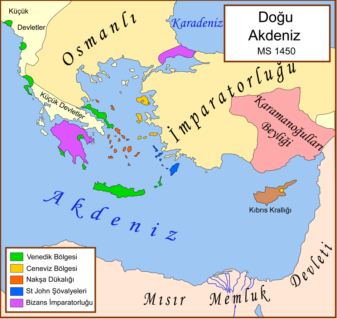
| Description | A political map of the eastern Mediterranean Sea, in 1450. |
| Date | 22 March 2008 (original upload date) |
| Source | No machine-readable source provided. Own work assumed (based on copyright claims). |
| Author | No machine-readable author provided. Kuara assumed (based on copyright claims). |
| Other versions |
[]
|


See also[edit]
References[edit]
- Sheperd's map of the Ottoman Empire, 1451 - 1481.[dead link]
- Bjorklund, Oddvar; Holmboe, Haakon; Rohr, Anders (1970) Historical Atlas of the World, Barnes & Noble, NY, SBN: 389-00253-4.
- Matthew, Donald, (1983), Atlas of Medieval Europe, Checkmark Books, New York.
- Image:Europe in 1430.PNG
- Image:Geschichte-Europ.Tuerkei.jpg
Licensing[edit]
I, the copyright holder of this work, hereby publish it under the following license:
This file is licensed under the Creative Commons Attribution-Share Alike 2.5 Generic license.
- You are free:
- to share – to copy, distribute and transmit the work
- to remix – to adapt the work
- Under the following conditions:
- attribution – You must give appropriate credit, provide a link to the license, and indicate if changes were made. You may do so in any reasonable manner, but not in any way that suggests the licensor endorses you or your use.
- share alike – If you remix, transform, or build upon the material, you must distribute your contributions under the same or compatible license as the original.
File history
Click on a date/time to view the file as it appeared at that time.
| Date/Time | Thumbnail | Dimensions | User | Comment | |
|---|---|---|---|---|---|
| current | 08:10, 22 March 2008 | | 2,529 × 2,395 (624 KB) | Kuara (talk | contribs) | png version |
You cannot overwrite this file.
File usage on Commons
The following 22 pages use this file:
- File:Bütsants1450.png
- File:Eastern Mediterranean 1450- sr lat.svg
- File:Eastern Mediterranean 1450-hu.svg
- File:Eastern Mediterranean 1450-ru.svg
- File:Eastern Mediterranean 1450-sr.svg
- File:Eastern Mediterranean 1450-zh.svg
- File:Eastern Mediterranean 1450.svg
- File:Eastern Mediterranean 1450 -HE.svg
- File:Eastern Mediterranean 1450 - Arabic.PNG
- File:Eastern Mediterranean 1450 - HE.svg
- File:Eastern Mediterranean 1450 el.svg
- File:Eastern Mediterranean 1450 es.svg
- File:Eastern Mediterranean 1450 pt.svg
- File:Eastern Mediterranean 1450 tr.png
- File:Eastern Mediterranean in 1450-hy.png
- File:Mediterraneo Orientale 1450.svg
- File:Mediterráneo Oriental 1450 d.C.svg
- File:Mediteràneo Orientàl 1450 - lmo.svg
- File:MéditerranéeOrient1450.PNG
- File:Se Easterna Wendelsæ in 1450.svg
- File:Östliches Mittelmeer 1450 DE.svg
- Template:Other versions/Eastern Mediterranean 1450
File usage on other wikis
The following other wikis use this file:
- Usage on azb.wikipedia.org
- Usage on crh.wikipedia.org
- Usage on ka.wikipedia.org
- Usage on tr.wikipedia.org
- Usage on uz.wikipedia.org