File:Eastern Mediterranean 1450.svg
(Redirected from File:Eastern Mediterranean 1450 .svg)

Size of this PNG preview of this SVG file: 632 × 600 pixels. Other resolutions: 253 × 240 pixels | 506 × 480 pixels | 810 × 768 pixels | 1,079 × 1,024 pixels | 2,159 × 2,048 pixels | 2,497 × 2,369 pixels.
Original file (SVG file, nominally 2,497 × 2,369 pixels, file size: 265 KB)
Captions
Captions
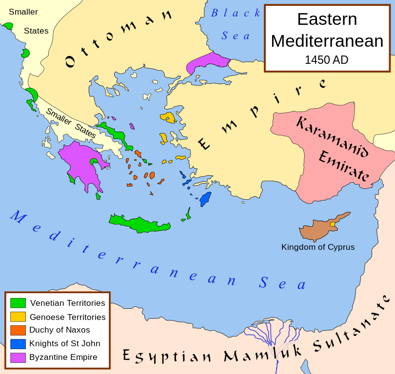
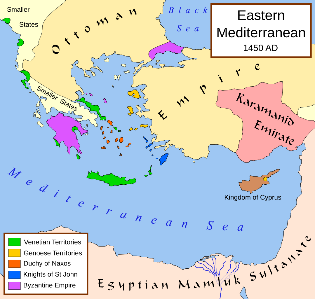
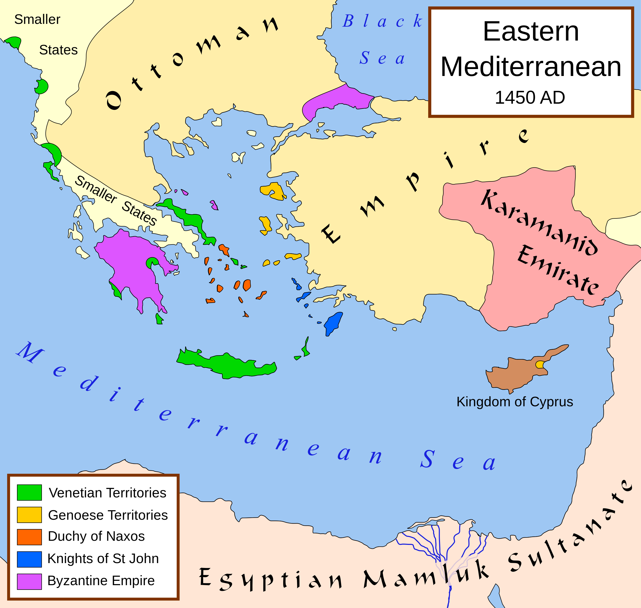
Political map of the eastern Mediterranean Sea, in 1450
Summary[edit]
| Description |
English: A political map of the eastern Mediterranean Sea, in 1450. |
| Date | |
| Source |
Own work using:
|
| Author | MapMaster |
| Other versions |
[]
|


|
This SVG file contains embedded text that can be translated into your language, using any capable SVG editor, text editor or the SVG Translate tool. For more information see: About translating SVG files. |
Licensing[edit]
I, the copyright holder of this work, hereby publish it under the following license:
This file is licensed under the Creative Commons Attribution-Share Alike 2.5 Generic license.
- You are free:
- to share – to copy, distribute and transmit the work
- to remix – to adapt the work
- Under the following conditions:
- attribution – You must give appropriate credit, provide a link to the license, and indicate if changes were made. You may do so in any reasonable manner, but not in any way that suggests the licensor endorses you or your use.
- share alike – If you remix, transform, or build upon the material, you must distribute your contributions under the same or compatible license as the original.
File history
Click on a date/time to view the file as it appeared at that time.
| Date/Time | Thumbnail | Dimensions | User | Comment | |
|---|---|---|---|---|---|
| current | 12:40, 9 July 2017 | | 2,497 × 2,369 (265 KB) | Joe Roe (talk | contribs) | removed black outer border |
| 12:10, 6 August 2013 |  | 2,529 × 2,395 (334 KB) | Phso2 (talk | contribs) | sporades | |
| 11:25, 1 July 2013 |  | 2,529 × 2,395 (333 KB) | Phso2 (talk | contribs) | cf disc | |
| 16:15, 16 October 2007 |  | 2,529 × 2,395 (333 KB) | MapMaster (talk | contribs) | small fix | |
| 18:56, 9 September 2007 |  | 2,529 × 2,395 (332 KB) | MapMaster (talk | contribs) | Further slight changes, particularly Thessaloniki. | |
| 04:23, 9 September 2007 |  | 2,529 × 2,395 (335 KB) | MapMaster (talk | contribs) | More changes based on Alekkas' research. | |
| 03:50, 7 September 2007 |  | 2,529 × 2,395 (348 KB) | MapMaster (talk | contribs) | Slight modifications based on information from User:Alekkas on my talk page. | |
| 03:08, 17 April 2007 |  | 2,529 × 2,395 (347 KB) | MapMaster (talk | contribs) | Added missing text | |
| 05:20, 14 April 2007 |  | 2,529 × 2,395 (321 KB) | MapMaster (talk | contribs) | slight update | |
| 20:52, 13 April 2007 |  | 2,529 × 2,395 (316 KB) | MapMaster (talk | contribs) | A political map of the eastern Mediterranean Sea, in 1450. |
You cannot overwrite this file.
File usage on Commons
The following 39 pages use this file:
- Atlas of the Ottoman Empire
- Eastern Mediterranean
- User:J budissin/Uploads/BiH/2017 July 1-10
- User:Kareyac/Armenia/2017 July 1-10
- User:MapMaster
- User talk:MapMaster
- File:Bütsants1450.png
- File:Duchy of Naxos locator.svg
- File:Eastern Mediterranean 1450- sr lat.svg
- File:Eastern Mediterranean 1450-hu.svg
- File:Eastern Mediterranean 1450-ru.svg
- File:Eastern Mediterranean 1450-sr.svg
- File:Eastern Mediterranean 1450-zh.svg
- File:Eastern Mediterranean 1450.svg
- File:Eastern Mediterranean 1450 -HE.svg
- File:Eastern Mediterranean 1450 - Arabic.PNG
- File:Eastern Mediterranean 1450 - HE.svg
- File:Eastern Mediterranean 1450 .svg (file redirect)
- File:Eastern Mediterranean 1450 el.svg
- File:Eastern Mediterranean 1450 es.svg
- File:Eastern Mediterranean 1450 pt.svg
- File:Eastern Mediterranean 1450 tr.png
- File:Eastern Mediterranean in 1450-hy.png
- File:Mediterraneo Orientale 1450.svg
- File:Mediterráneo Oriental 1450 d.C.svg
- File:Mediteràneo Orientàl 1450 - lmo.svg
- File:MéditerranéeOrient1450.PNG
- File:Se Easterna Wendelsæ in 1450.svg
- File:Östliches Mittelmeer 1450 DE.svg
- Template:Other versions/Eastern Mediterranean 1450
- Category:Karamanids
File usage on other wikis
The following other wikis use this file:
- Usage on ar.wikipedia.org
- Usage on ast.wikipedia.org
- Usage on azb.wikipedia.org
- Usage on az.wikipedia.org
- Usage on be.wikipedia.org
- Usage on bg.wikipedia.org
- Usage on bn.wikipedia.org
- Usage on bs.wikipedia.org
- Usage on ca.wikipedia.org
- Usage on cs.wikipedia.org
- Usage on de.wikipedia.org
- Usage on el.wikipedia.org
- Usage on en.wikipedia.org
- Constantine XI Palaiologos
- Succession of the Roman Empire
- Karamanids
- Imbros
- Duchy of the Archipelago
- House of Lusignan
- Giosafat Barbaro
- User:MapMaster
- History of the Republic of Venice
- Knights Hospitaller
- Byzantine–Ottoman wars
- Hospitaller Rhodes
- Frankokratia
- Byzantine Empire
- Stato da Màr
- History of the Byzantine Empire
- Ottoman–Venetian War (1463–1479)
View more global usage of this file.
Metadata
Categories:
- Maps of the history of the Ottoman Empire in the 1450s
- Maps of the history of Greece
- Orders of chivalry
- Stato da Màr
- Maps of the Republic of Venice
- Maps of the Republic of Genoa
- Maps of the Duchy of the Archipelago
- Maps of the Order of Saint John of Jerusalem
- Karamanids
- Maps of Anatolian beyliks
- Greece in the 15th century
- Turkey in the 15th century
- Egypt in the 15th century
- 1450