File:Eastern Mediterranean 1450 -HE.svg
Jump to navigation
Jump to search

Size of this PNG preview of this SVG file: 633 × 599 pixels. Other resolutions: 253 × 240 pixels | 507 × 480 pixels | 811 × 768 pixels | 1,081 × 1,024 pixels | 2,163 × 2,048 pixels | 2,529 × 2,395 pixels.
Original file (SVG file, nominally 2,529 × 2,395 pixels, file size: 319 KB)
Captions
Captions
Add a one-line explanation of what this file represents
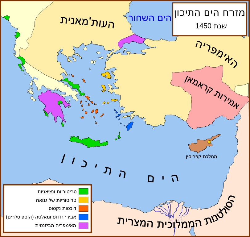
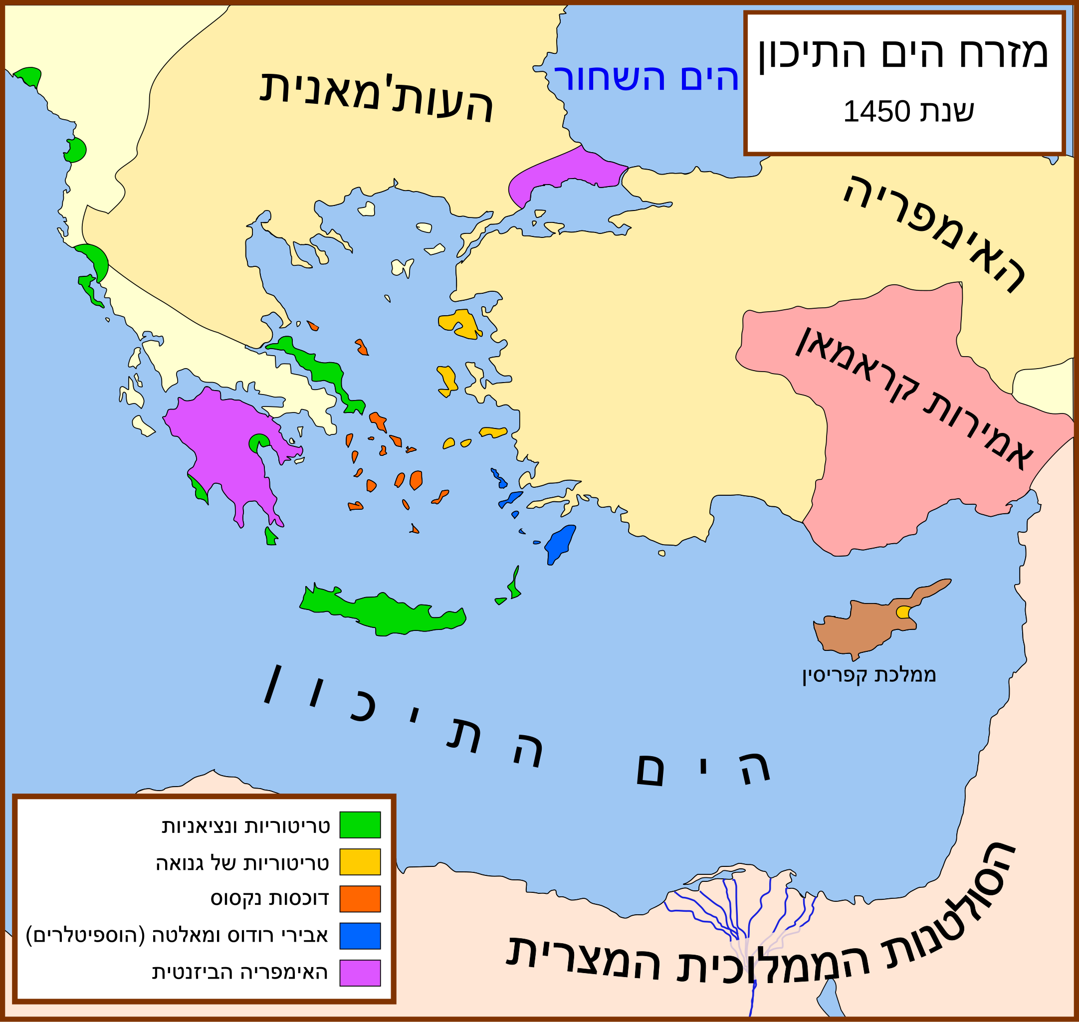
| Description | A political map of the eastern Mediterranean Sea, in 1450. *English * Español *Italiano *Türkçe *Image:Despotate of Morea 1450.svg *Sheperd's map of the Ottoman Empire, 1451 - 1481. *Bjorklund, Oddvar; Holmboe, Haakon; Rohr, Anders (1970) Historical Atlas of the World, Barnes & Noble, NY, SBN: 389-00253-4. *Matthew, Donald, (1983), Atlas of Medieval Europe, Checkmark Books, New York. *Image:Europe in 1430.PNG *Image:Geschichte-Europ.Tuerkei.jpg |
| Date | (UTC) |
| Source | |
| Author |
|
| Other versions |
[]
|


| This is a retouched picture, which means that it has been digitally altered from its original version. Modifications: added Hebrew svg. The original can be viewed here: Eastern Mediterranean 1450 .svg:
|
I, the copyright holder of this work, hereby publish it under the following license:
This file is licensed under the Creative Commons Attribution-Share Alike 2.5 Generic license.
- You are free:
- to share – to copy, distribute and transmit the work
- to remix – to adapt the work
- Under the following conditions:
- attribution – You must give appropriate credit, provide a link to the license, and indicate if changes were made. You may do so in any reasonable manner, but not in any way that suggests the licensor endorses you or your use.
- share alike – If you remix, transform, or build upon the material, you must distribute your contributions under the same or compatible license as the original.
Original upload log[edit]
This image is a derivative work of the following images:
- File:Eastern_Mediterranean_1450_.svg licensed with Cc-by-sa-2.5
- 2007-10-16T16:15:53Z MapMaster 2529x2395 (340853 Bytes) small fix
- 2007-09-09T18:56:03Z MapMaster 2529x2395 (340171 Bytes) Further slight changes, particularly Thessaloniki.
- 2007-09-09T04:23:48Z MapMaster 2529x2395 (342637 Bytes) More changes based on Alekkas' research.
- 2007-09-07T03:50:51Z MapMaster 2529x2395 (356148 Bytes) Slight modifications based on information from [[User:Alekkas]] on my talk page.
- 2007-04-17T03:08:03Z MapMaster 2529x2395 (355411 Bytes) Added missing text
- 2007-04-14T05:20:46Z MapMaster 2529x2395 (329143 Bytes) slight update
- 2007-04-13T20:52:25Z MapMaster 2529x2395 (323087 Bytes) A political map of the eastern Mediterranean Sea, in 1450.
Uploaded with derivativeFX
File history
Click on a date/time to view the file as it appeared at that time.
| Date/Time | Thumbnail | Dimensions | User | Comment | |
|---|---|---|---|---|---|
| current | 18:29, 3 May 2009 | | 2,529 × 2,395 (319 KB) | Odedee (talk | contribs) | minor fix |
| 18:25, 3 May 2009 |  | 2,529 × 2,395 (315 KB) | Odedee (talk | contribs) | {{Information |Description=A political map of the eastern Mediterranean Sea, in 1450. *English * Español *Italiano * |
You cannot overwrite this file.
File usage on Commons
The following 22 pages use this file:
- File:Bütsants1450.png
- File:Eastern Mediterranean 1450- sr lat.svg
- File:Eastern Mediterranean 1450-hu.svg
- File:Eastern Mediterranean 1450-ru.svg
- File:Eastern Mediterranean 1450-sr.svg
- File:Eastern Mediterranean 1450-zh.svg
- File:Eastern Mediterranean 1450.svg
- File:Eastern Mediterranean 1450 -HE.svg
- File:Eastern Mediterranean 1450 - Arabic.PNG
- File:Eastern Mediterranean 1450 - HE.svg
- File:Eastern Mediterranean 1450 el.svg
- File:Eastern Mediterranean 1450 es.svg
- File:Eastern Mediterranean 1450 pt.svg
- File:Eastern Mediterranean 1450 tr.png
- File:Eastern Mediterranean in 1450-hy.png
- File:Mediterraneo Orientale 1450.svg
- File:Mediterráneo Oriental 1450 d.C.svg
- File:Mediteràneo Orientàl 1450 - lmo.svg
- File:MéditerranéeOrient1450.PNG
- File:Se Easterna Wendelsæ in 1450.svg
- File:Östliches Mittelmeer 1450 DE.svg
- Template:Other versions/Eastern Mediterranean 1450