File:Eastern Armenia October 1918 map.png
Jump to navigation
Jump to search

Size of this preview: 550 × 599 pixels. Other resolutions: 220 × 240 pixels | 582 × 634 pixels.
Original file (582 × 634 pixels, file size: 43 KB, MIME type: image/png)
Captions
Captions
Add a one-line explanation of what this file represents
Summary[edit]
| Description |
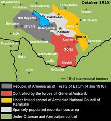
English: Map of South Caucasus in October 1918 based on this map of Andrew Andersen and George Egge, 2010 |
| Date | |
| Source | Own work |
| Author | Yerevanci |
Licensing[edit]
I, the copyright holder of this work, hereby publish it under the following license:
This file is licensed under the Creative Commons Attribution-Share Alike 3.0 Unported license.
- You are free:
- to share – to copy, distribute and transmit the work
- to remix – to adapt the work
- Under the following conditions:
- attribution – You must give appropriate credit, provide a link to the license, and indicate if changes were made. You may do so in any reasonable manner, but not in any way that suggests the licensor endorses you or your use.
- share alike – If you remix, transform, or build upon the material, you must distribute your contributions under the same or compatible license as the original.
File history
Click on a date/time to view the file as it appeared at that time.
| Date/Time | Thumbnail | Dimensions | User | Comment | |
|---|---|---|---|---|---|
| current | 01:18, 11 August 2012 | | 582 × 634 (43 KB) | Yerevanci (talk | contribs) | better version |
| 00:29, 8 August 2012 |  | 583 × 678 (44 KB) | Yerevanci (talk | contribs) | fixing minor issues | |
| 22:53, 7 August 2012 |  | 583 × 678 (44 KB) | Yerevanci (talk | contribs) | minor spelling | |
| 20:01, 7 August 2012 |  | 583 × 678 (43 KB) | Yerevanci (talk | contribs) | names | |
| 19:57, 7 August 2012 |  | 583 × 678 (33 KB) | Yerevanci (talk | contribs) |
You cannot overwrite this file.
File usage on Commons
There are no pages that use this file.
File usage on other wikis
The following other wikis use this file:
- Usage on en.wikipedia.org
- Usage on fr.wikipedia.org
- Usage on he.wikipedia.org
- Usage on ru.wikipedia.org
- Usage on sr.wikipedia.org