File:East Troublesome Fire area.jpg
Original file (3,513 × 2,538 pixels, file size: 2.14 MB, MIME type: image/jpeg)
Captions
Captions
Summary[edit]
| Description |
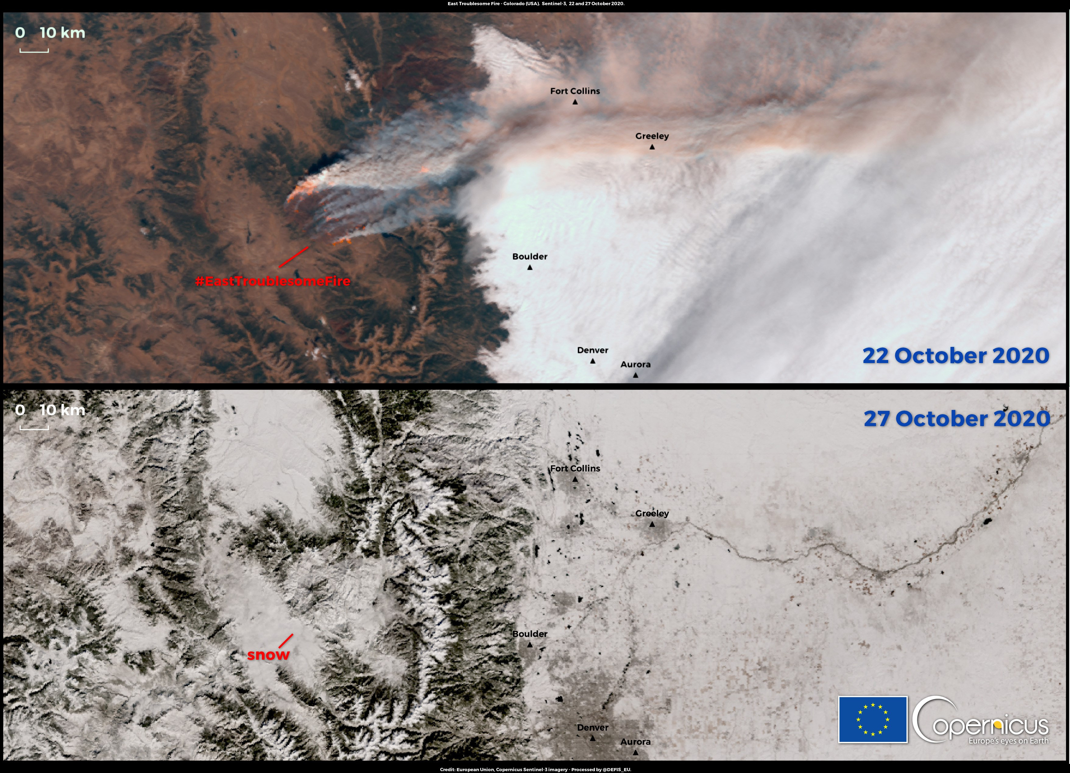
English: Although the wildfires in California and Oregon have received more attention, the state of Colorado has also been heavily affected by wildfires since July 2020. The state has seen its two largest fires in modern history this year. The Cameron Peak fire, officially the largest in state history, has burned up more than 83,000 hectares (830 km2) of land since mid-August. The second-largest blaze in state history, the East Troublesome Fire, started on 13 October and grew by 56,000 hectares in a single night a few days later. It has burned up more than 77,000 hectares of land and produced a smoke cloud that travelled all the way over to Europe. On 25 October the first snowstorm of autumn arrived in Colorado and provided some relief to the firefighters currently trying to contain the wildfires. In spite of this, firefighters are concerned that the snow will only slow and not stop the fire as it melts away. These images provide a view of the East Troublesome Fire on two different days. The first one, captured on 22 October, clearly shows the wildfire’s hotspots inside the burned area. The second image, which was captured on 27 October, is a natural colour image in which it is possible to see the wildfire area completely covered by snow. Both images have been captured by one of the Copernicus Sentinel-3 satellites, using data retrieved from the OLCI and SLSTR sensors. The Copernicus Sentinel-3 mission is composed of two twin satellites (Sentinel-3A and Sentinel-3B) that are equipped with 3 main instruments. Besides a SAR RADAR Altimeter (SRAL), two optical sensors are also onboard: one of them is the Ocean Land Colour Instrument (OLCI) with the primary objective of screening the ocean and land surfaces to harvest biological information (e.g. phenology of marine and terrestrial biomass). OLCI also provides reliable information on Earth’s atmosphere. The other is the Sea and Land Surface Temperature Radiometer that provides many applications for both the land and marine domain, such as retrieving Land Surface Temperature and Sea Surface Temperature or to detect and quantify actively burning fires through their emitted radiation signals (Fire detection and Fire Radiative Power data products). |
| Date | 28 October 2020 (upload date) |
| Source | East Troublesome Fire area |
| Author | European Union , Copernicus Sentinel-3 imagery |
Licensing[edit]

|
This image contains data from a satellite in the Copernicus Programme, such as Sentinel-1, Sentinel-2 or Sentinel-3. Attribution is required when using this image.
Attribution: Contains modified Copernicus Sentinel data 2020
The use of Copernicus Sentinel Data is regulated under EU law (Commission Delegated Regulation (EU) No 1159/2013 and Regulation (EU) No 377/2014). Relevant excerpts:
Free access shall be given to GMES dedicated data [...] made available through GMES dissemination platforms [...].
Access to GMES dedicated data [...] shall be given for the purpose of the following use in so far as it is lawful:
GMES dedicated data [...] may be used worldwide without limitations in time.
GMES dedicated data and GMES service information are provided to users without any express or implied warranty, including as regards quality and suitability for any purpose. |
File history
Click on a date/time to view the file as it appeared at that time.
| Date/Time | Thumbnail | Dimensions | User | Comment | |
|---|---|---|---|---|---|
| current | 13:17, 9 August 2023 | | 3,513 × 2,538 (2.14 MB) | OptimusPrimeBot (talk | contribs) | #Spacemedia - Upload of https://www.copernicus.eu/system/files/2020-10/image_day/EastTroublesomeFire_credit_row.jpg via Commons:Spacemedia |
You cannot overwrite this file.
File usage on Commons
There are no pages that use this file.