File:East Siberian Sea map.png
Jump to navigation
Jump to search

Size of this preview: 800 × 445 pixels. Other resolutions: 320 × 178 pixels | 640 × 356 pixels | 1,192 × 663 pixels.
Original file (1,192 × 663 pixels, file size: 116 KB, MIME type: image/png)
Captions
Captions
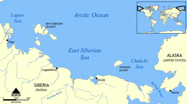
Location of the East Siberian Sea
| Description |
English: Map showing the location of the East Siberian Sea, part of the Arctic Ocean, located north of Siberia and between the Laptev Sea and Chukchi Sea.
Français : Carte de localisation de la mer de Sibérie orientale |
||||||||
| Date | |||||||||
| Source | Own work | ||||||||
| Author | Own work | ||||||||
| Permission (Reusing this file) |
I, the copyright holder of this work, hereby publish it under the following license:
|
||||||||
| Other versions | Derivative works of this file: East Siberian Sea map hr.svg |

File history
Click on a date/time to view the file as it appeared at that time.
| Date/Time | Thumbnail | Dimensions | User | Comment | |
|---|---|---|---|---|---|
| current | 19:25, 24 October 2014 | | 1,192 × 663 (116 KB) | Beao (talk | contribs) | Removed border. |
| 18:01, 30 May 2006 |  | 1,200 × 671 (116 KB) | NormanEinstein (talk | contribs) | Map showing the location of the East Siberian Sea, part of the Arctic Ocean, located north of Siberia and between the Laptev Sea and Chukchi Sea. Created by NormanEinstein, May 20, 2006. {{GFDL-self}} Category:Maps of seas |
You cannot overwrite this file.
File usage on Commons
The following 2 pages use this file:
File usage on other wikis
The following other wikis use this file:
- Usage on af.wikipedia.org
- Usage on ar.wikipedia.org
- Usage on azb.wikipedia.org
- Usage on az.wikipedia.org
- Usage on az.wiktionary.org
- Usage on bg.wikipedia.org
- Usage on bn.wikipedia.org
- Usage on br.wikipedia.org
- Usage on bs.wikipedia.org
- Usage on cs.wikipedia.org
- Usage on da.wikipedia.org
- Usage on de.wikipedia.org
- Usage on el.wikipedia.org
- Usage on en.wikipedia.org
- Usage on eo.wikipedia.org
- Usage on es.wikipedia.org
- Usage on fa.wikipedia.org
- Usage on fi.wikipedia.org
- Usage on fr.wikipedia.org
- Usage on gl.wikipedia.org
- Usage on hi.wikipedia.org
- Usage on hu.wiktionary.org
- Usage on ilo.wikipedia.org
- Usage on is.wikipedia.org
- Usage on it.wikipedia.org
- Usage on ja.wikipedia.org
- Usage on ka.wikipedia.org
- Usage on kbd.wikipedia.org
- Usage on kk.wikipedia.org
- Usage on ko.wikipedia.org
- Usage on ku.wikipedia.org
- Usage on li.wikipedia.org
- Usage on lt.wikipedia.org
- Usage on mk.wikipedia.org
- Usage on ml.wikipedia.org
- Usage on mn.wikipedia.org
- Usage on mr.wikipedia.org
- Usage on ms.wikipedia.org
- Usage on nn.wikipedia.org
- Usage on no.wikipedia.org
View more global usage of this file.