File:EastJerusalemMap-de.svg
Jump to navigation
Jump to search

Size of this PNG preview of this SVG file: 384 × 589 pixels. Other resolutions: 156 × 240 pixels | 313 × 480 pixels | 501 × 768 pixels | 667 × 1,024 pixels | 1,335 × 2,048 pixels.
Original file (SVG file, nominally 384 × 589 pixels, file size: 87 KB)
Captions
Captions
Add a one-line explanation of what this file represents
Summary[edit]
| Description |
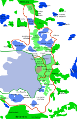
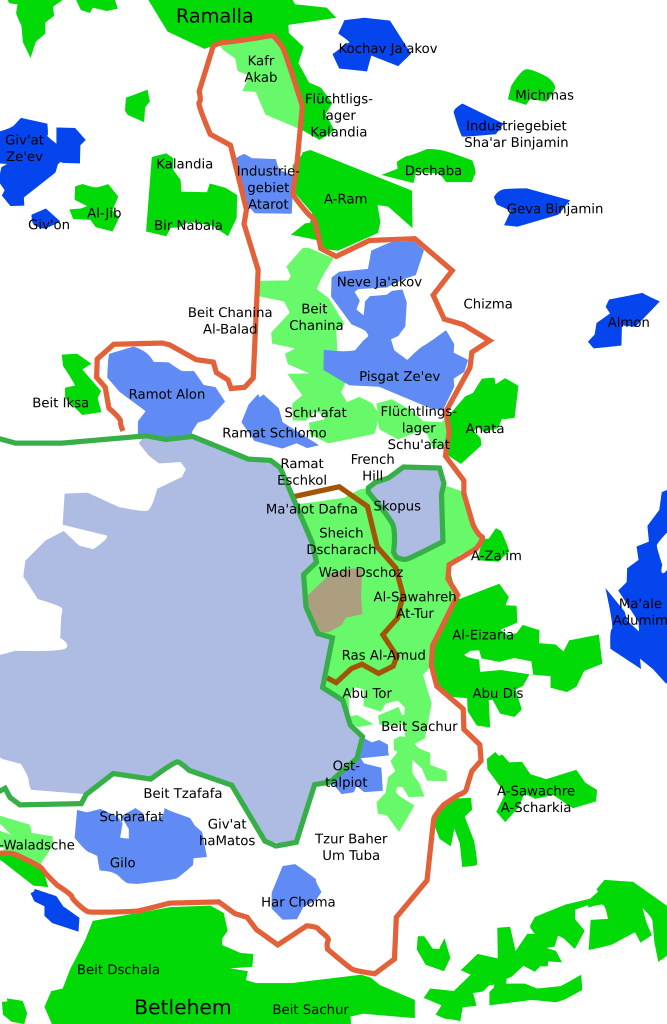
[] Deutsch: Karte Jerusalems:
Westjerusalem und Skopusberg
Waffenstillstandslinie von 1949
Altstadt
Arabische Viertel in Ostjerusalem
Stadtgrenze bis 1967
Jüdische Viertel in Ostjerusalem
Stadtgrenze
Jüdische Gebiete im Westjordanland
Arabische Gebiete im Westjordanland
English: Map of Jerusalem:
West Jerusalem and Mount Scopus
1949 armistice line
Old City, fully annexed by Israel
East Jerusalem, occupied Arab areas, annexed by Israel
Pre-1967 municipal boundary
East Jerusalem, Jewish colonies, annexed by Israel
Current Israeli extended boundary of the municipality and of the district of Jerusalem
West Bank, Jewish colonies in the new district of Samaria and Judea (zone C)
West Bank, occupied Arab areas (zone A, partially controled by the Palestinian National Authority)
Español: Mapa de Jerusalén:
Jerusalén Oeste y Monte Scopus
Frontera de armisticio de 1949
Ciudad Vieja
Jerusalén Este, áreas árabes
Frontera anterior a 1967
Jerusalén Este, áreas judías
Frontera de Jerusalén
Cisjordania, áreas judías
Cisjordania, áreas árabes
Français : Carte de Jérusalem :
Jérusalem-Ouest et Mont Scopus
Ligne d'armistice de 1949
Vieille ville, entièrement annexée par Israël
Jérusalem-Est, secteurs arabes occupés par Israël
Frontière municipale avant 1967
Jérusalem-Est, colonies juives annexées par Israël après 1967
Frontière actuelle d'extension israélienne de la municipalité et du district de Jérusalem
Cisjordanie, colonies juives dans le nouveau district israélien de Samarie et de Judée (zone C)
Cisjordanie, secteurs arabes occupés (zone A, partiellement contrôlée par l'Autorité nationale palestinienne)
|
||
| Date | (UTC) | ||
| Source |
|
||
| Author | Doron, Chabacano, עין לציון | ||
| Other versions |
[]
|


Licensing[edit]
I, the copyright holder of this work, hereby publish it under the following licenses:
| This file is licensed under the Creative Commons Attribution-Share Alike 3.0 Unported license. | ||
| ||
| This licensing tag was added to this file as part of the GFDL licensing update. |

|
Permission is granted to copy, distribute and/or modify this document under the terms of the GNU Free Documentation License, Version 1.2 or any later version published by the Free Software Foundation; with no Invariant Sections, no Front-Cover Texts, and no Back-Cover Texts. A copy of the license is included in the section entitled GNU Free Documentation License. |
You may select the license of your choice.
Original upload log[edit]
This image is a derivative work of the following images:
- File:EastJerusalemMap.svg licensed with Cc-by-sa-3.0-migrated, GFDL
- 2009-08-01T00:55:05Z Kordas 384x589 (89660 Bytes) translated names
- 2007-06-26T18:31:49Z Ignacio Icke 384x589 (89257 Bytes)
- 2007-06-11T20:42:27Z Ignacio Icke 384x589 (88525 Bytes) {{Information |Description=Mapa de Jerusalén este: {{legend|#ac9f7f|Casco antiguo}} {{legend|#aebbe3|Jerusalén oeste}}{{legend|#5f8af6|Jerusalén este}}{{legend|#0049ee|West bank, áreas judías}}{{legend|#67f96c|Jerusalén
Uploaded with derivativeFX
File history
Click on a date/time to view the file as it appeared at that time.
| Date/Time | Thumbnail | Dimensions | User | Comment | |
|---|---|---|---|---|---|
| current | 13:42, 16 October 2011 | | 384 × 589 (87 KB) | Ayin leZion (talk | contribs) | == {{int:filedesc}} == {{Information |Description={{de}}Karte Jerusalems: {{legend|#ac9f7f|Altstadt}} {{legend|#aebbe3|Westjerusalem und Skopusberg}} {{legend|#5f8af6|Jüdische Viertel in Ostjerusalem}} {{legend|#0049ee|Jüdische Gebiete im Westjordanlan |
You cannot overwrite this file.
File usage on Commons
The following 17 pages use this file:
- File:1949-67-JerusalemMap-he.svg
- File:EastJerusalemMap-de.svg
- File:EastJerusalemMap-en.svg
- File:EastJerusalemMap-es.svg
- File:EastJerusalemMap.jpg
- File:EastJerusalemMapHE.jpg
- File:EastJerusalemMapHE1a.PNG
- File:MapJerusalemNeighbourhoodsGerman.svg (file redirect)
- Template:Other versions/East Jerusalem Map
File usage on other wikis
The following other wikis use this file:
- Usage on de.wikipedia.org
- Usage on frr.wikipedia.org