File:Earth from Space- American Samoa ESA25346475.jpg

Original file (3,840 × 2,160 pixels, file size: 4.51 MB, MIME type: image/jpeg)
Captions
Captions
Summary[edit]
| Description |
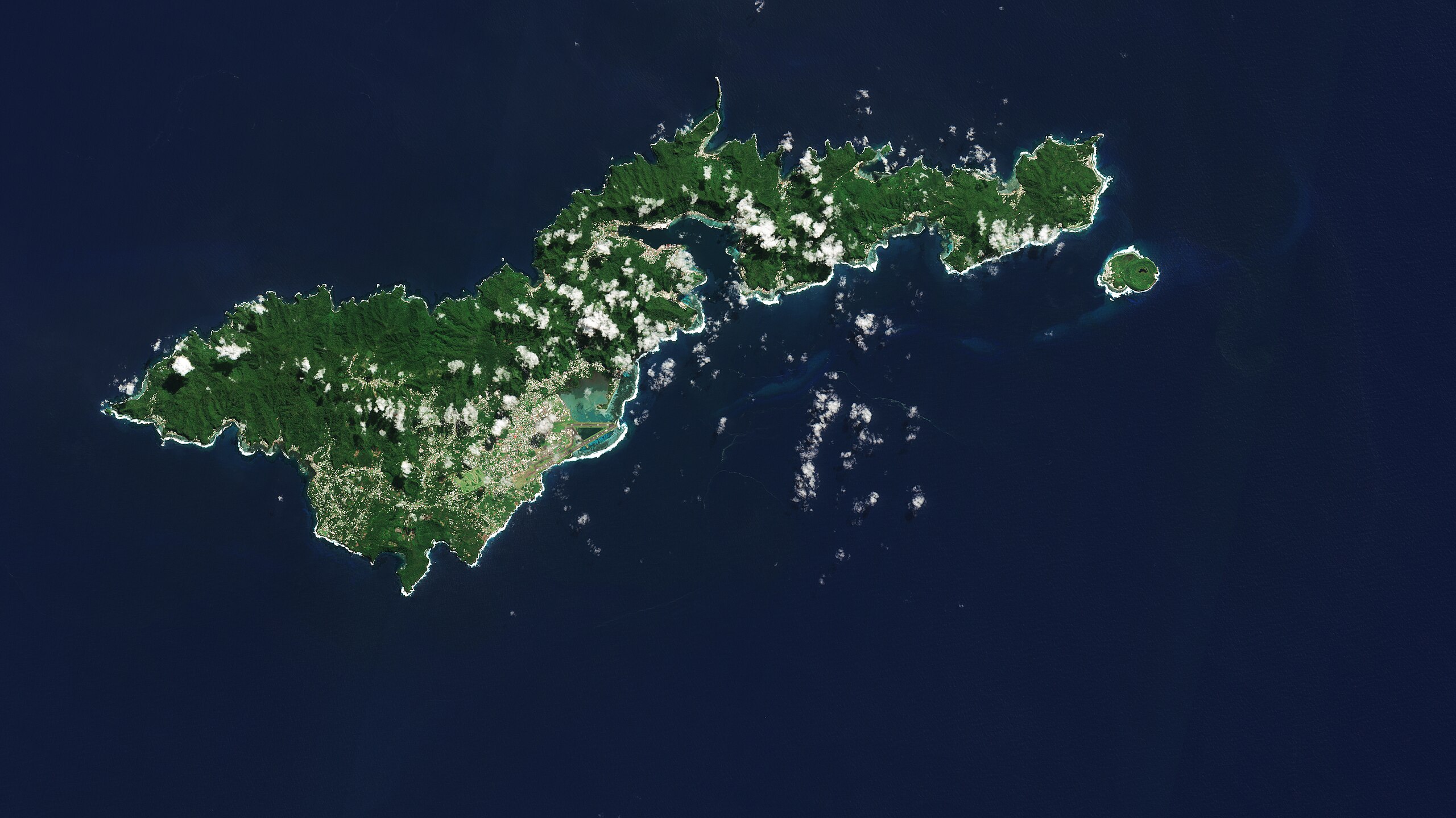
English: The Copernicus Sentinel-2 mission shows us an amazing view of the tropical island of Tutuila, the largest in the American Samoa archipelago in the South Pacific Ocean. Zoom in to explore this image at its full 10 m resolution or click on the circles to learn more. American Samoa is an unincorporated territory of the US and is part of the Samoan Islands chain, situated some 4000 km southwest of Hawaii and about 3000 km northwest of New Zealand. The eastern part of the chain of islands forms the American Samoa, while the western part forms the independent state of Samoa. American Samoa comprises five volcanic islands, Tutuila, Aunu'u, Tau, Ofu and Olosega, and two coral atolls, Rose and Swains. Tutuila is a small, narrow island and home to many volcanic mountains. At 653 m, Mount Matafao, which lies in the centre of the island, is the highest. The mountain range, which cuts across the island, is rugged with steep cliffs dominating the northern part of the island. The south is flatter. Coral reefs create barriers to the open sea, resulting in lagoons, visible in turquoise, prominent off the southern coast. Tutuila is home to the capital of American Samoa, Pago Pago, which lies on the deepest inlet that divides the island nearly in two. Served by a busy harbour, the Pago Pago urban area encompasses several villages and popular beaches. It also features part of the National Park of American Samoa, where thick tropical rainforest and pristine coral reefs are protected. The park is the only US national park in the South Pacific. About 10 km southwest of the city, the runways of the Pago Pago International Airport, partly built on a fringing reef, can be easily spotted in the image. The small volcanic island off the southeast coast of Tutuila is Aunu’u. It covers about 1.5 sq km and features the Faimulivai Marsh, a freshwater marsh visible as a dark area on the eastern part of the island. A protected National Natural Landmark, the Faimulivai Marsh was formed from drainage of the low-lying Aunu’u Crater and is the largest such wetland in American Samoa. |
| Date | 1 December 2023 (upload date) |
| Source | Earth from Space: American Samoa |
| Author | European Space Agency |
| Other versions |
|
| Activity | Observing the Earth |
| Mission | Sentinel-2 |
| Set | Earth from Space image collection |
| System | Copernicus |
Licensing[edit]

|
This image contains data from a satellite in the Copernicus Programme, such as Sentinel-1, Sentinel-2 or Sentinel-3. Attribution is required when using this image.
Attribution: Contains modified Copernicus Sentinel data 2023
The use of Copernicus Sentinel Data is regulated under EU law (Commission Delegated Regulation (EU) No 1159/2013 and Regulation (EU) No 377/2014). Relevant excerpts:
Free access shall be given to GMES dedicated data [...] made available through GMES dissemination platforms [...].
Access to GMES dedicated data [...] shall be given for the purpose of the following use in so far as it is lawful:
GMES dedicated data [...] may be used worldwide without limitations in time.
GMES dedicated data and GMES service information are provided to users without any express or implied warranty, including as regards quality and suitability for any purpose. |
This media was created by the European Space Agency (ESA).
Where expressly so stated, images or videos are covered by the Creative Commons Attribution-ShareAlike 3.0 IGO (CC BY-SA 3.0 IGO) licence, ESA being an Intergovernmental Organisation (IGO), as defined by the CC BY-SA 3.0 IGO licence. The user is allowed under the terms and conditions of the CC BY-SA 3.0 IGO license to Reproduce, Distribute and Publicly Perform the ESA images and videos released under CC BY-SA 3.0 IGO licence and the Adaptations thereof, without further explicit permission being necessary, for as long as the user complies with the conditions and restrictions set forth in the CC BY-SA 3.0 IGO licence, these including that:
See the ESA Creative Commons copyright notice for complete information, and this article for additional details.
|
 | |
This file is licensed under the Creative Commons Attribution-ShareAlike 3.0 IGO license. Attribution: ESA, CC BY-SA IGO 3.0
| ||
File history
Click on a date/time to view the file as it appeared at that time.
| Date/Time | Thumbnail | Dimensions | User | Comment | |
|---|---|---|---|---|---|
| current | 06:02, 2 December 2023 | | 3,840 × 2,160 (4.51 MB) | OptimusPrimeBot (talk | contribs) | #Spacemedia - Upload of https://www.esa.int/var/esa/storage/images/esa_multimedia/images/2023/12/earth_from_space_american_samoa/25346465-1-eng-GB/Earth_from_Space_American_Samoa.jpg via Commons:Spacemedia |
You cannot overwrite this file.
File usage on Commons
There are no pages that use this file.