File:Earnslaw Pool, near Great Malvern - geograph.org.uk - 834847.jpg
Jump to navigation
Jump to search

Size of this preview: 450 × 600 pixels. Other resolutions: 180 × 240 pixels | 480 × 640 pixels.
Original file (480 × 640 pixels, file size: 137 KB, MIME type: image/jpeg)
Captions
Captions
Add a one-line explanation of what this file represents
Summary[edit]
| Description |
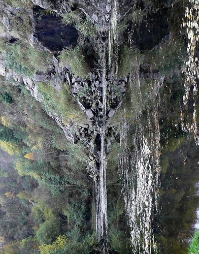
English: Earnslaw Pool, near Great Malvern Yet another image of what was once a quarry and is now a rather deep pool. A potted history is that an Alfred Earnslaw owned the quarry where, starting in 1836, granite was extracted. Out of the proceeds Alfred built Earnslaw House nearby, the drive to which from the main road now provides the access route to the pool. The house was demolished in 1936. Four years earlier there had been a serious landslip caused by the quarrying leading to a legal action against the quarry by the Conservators of the Malverns, which they won. Damages and costs were awarded against the quarry in the amount of almost £6000. By the 1960s the quarry was almost worked out and the then Worcestershire County Council purchased the site and handed it over to the Conservators. Part of the quarry filled up with spring water forming the pool we see today. Apparently there are fish in it. The quarry is now part of the Malvern Hills Site of Special Scientific Interest.
For a slightly different take on this scene see http://farm4.static.flickr.com/3093/2922897286_741825a866.jpg |
| Date | |
| Source | From geograph.org.uk |
| Author | Brian Robert Marshall |
| Attribution (required by the license) | Brian Robert Marshall / Earnslaw Pool, near Great Malvern / |
| Camera location | | View this and other nearby images on: OpenStreetMap |
|---|
| Object location | | View this and other nearby images on: OpenStreetMap |
|---|
Licensing[edit]

|
This image was taken from the Geograph project collection. See this photograph's page on the Geograph website for the photographer's contact details. The copyright on this image is owned by Brian Robert Marshall and is licensed for reuse under the Creative Commons Attribution-ShareAlike 2.0 license.
|
This file is licensed under the Creative Commons Attribution-Share Alike 2.0 Generic license.
Attribution: Brian Robert Marshall
- You are free:
- to share – to copy, distribute and transmit the work
- to remix – to adapt the work
- Under the following conditions:
- attribution – You must give appropriate credit, provide a link to the license, and indicate if changes were made. You may do so in any reasonable manner, but not in any way that suggests the licensor endorses you or your use.
- share alike – If you remix, transform, or build upon the material, you must distribute your contributions under the same or compatible license as the original.

_heading:202.00&language=en)
_heading:202.00&language=en)
File history
Click on a date/time to view the file as it appeared at that time.
| Date/Time | Thumbnail | Dimensions | User | Comment | |
|---|---|---|---|---|---|
| current | 19:09, 20 February 2011 | | 480 × 640 (137 KB) | GeographBot (talk | contribs) | == {{int:filedesc}} == {{Information |description={{en|1=Earnslaw Pool, near Great Malvern Yet another image of what was once a quarry and is now a rather deep pool. A potted history is that an Alfred Earnslaw owned the quarry where, starting in 1836, gra |
You cannot overwrite this file.
File usage on Commons
There are no pages that use this file.