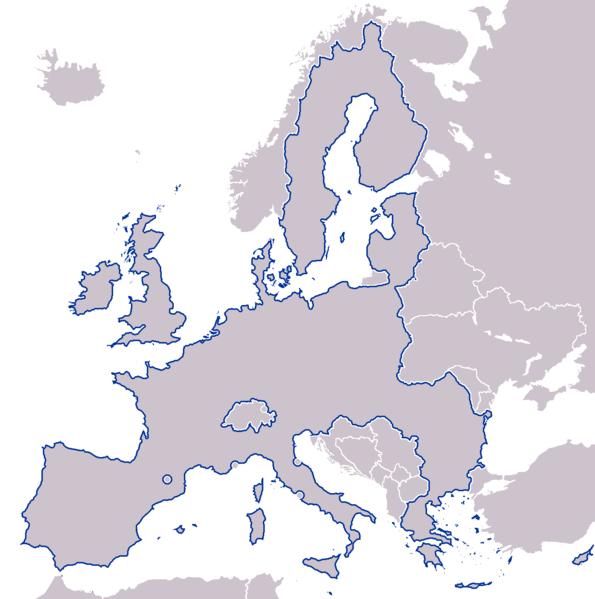
File:EU borders in Europe.png
From Wikimedia Commons, the free media repository
Jump to navigation
Jump to search

Size of this preview: 595 × 599 pixels. Other resolutions: 238 × 240 pixels | 477 × 480 pixels | 762 × 768 pixels | 1,236 × 1,245 pixels.
Original file (1,236 × 1,245 pixels, file size: 54 KB, MIME type: image/png)
File information
Structured data
Captions
Captions
Add a one-line explanation of what this file represents

|
This file requires updating because: Add Croatia and the United Kingdom has been withdrew from the European Union. In doing so, you could add a timestamp to the file.
|
| DescriptionEU borders in Europe.png | EU borders in Europe |
| Date | (UTC) |
| Source | |
| Author |
|
| This is a retouched picture, which means that it has been digitally altered from its original version. Modifications: outlining the EU territory instead of highlight it. The original can be viewed here: European Union as a single entity.png:
|

|
Permission is granted to copy, distribute and/or modify this document under the terms of the GNU Free Documentation License, Version 1.2 or any later version published by the Free Software Foundation; with no Invariant Sections, no Front-Cover Texts, and no Back-Cover Texts. A copy of the license is included in the section entitled GNU Free Documentation License.http://www.gnu.org/copyleft/fdl.htmlGFDLGNU Free Documentation Licensetruetrue |
| This file is licensed under the Creative Commons Attribution-Share Alike 3.0 Unported license. | ||
| ||
| This licensing tag was added to this file as part of the GFDL licensing update.http://creativecommons.org/licenses/by-sa/3.0/CC BY-SA 3.0Creative Commons Attribution-Share Alike 3.0truetrue |
Original upload log[edit]
This image is a derivative work of the following images:
- Image:European_Union_as_a_single_entity.png licensed with GFDL-en
- 2008-03-13T16:37:19Z Nightstallion 1236x1245 (75425 Bytes) upload a variant if you wish, but the majority in Europe recognises or will recognise.
- 2008-03-11T18:19:59Z Avala 1236x1245 (75290 Bytes) there is no consensus in European Union
- 2008-02-25T23:02:30Z Nightstallion 1236x1245 (75425 Bytes) Reverted to version as of :, 0 <>
- 2008-02-25T21:26:38Z Cp6 1236x1245 (75290 Bytes) Reverted to version as of :, 0 <>
- 2008-02-25T20:51:48Z Nightstallion 1236x1245 (75425 Bytes) Reverted to version as of :, 0 <>
- 2008-02-25T20:30:32Z Cp6 1236x1245 (75290 Bytes) Reverted to version as of :, 0 <> the same
- 2008-02-25T20:24:31Z Nightstallion 1236x1245 (75425 Bytes) Reverted to version as of :, 0 <>
- 2008-02-25T20:16:39Z Cp6 1236x1245 (75290 Bytes) Reverted to version as of 11:06, 28 December 2006 Kosovo no state
- 2008-02-23T23:19:42Z Hoshie 1236x1245 (75425 Bytes) added Kosovo after a request
- 2006-12-28T11:06:03Z Nightstallion 1236x1245 (75290 Bytes)
- 2006-06-21T09:43:27Z Nightstallion 1236x1245 (75865 Bytes) Reverted to earlier revision
- 2006-06-21T09:43:18Z Nightstallion 1236x1245 (75805 Bytes) Reverted to earlier revision
- 2006-06-14T02:15:34Z Hoshie 1236x1245 (75865 Bytes) The EU map has been fixed to show the SBAs on Cyprus, Isle of Man, Jersey, and Guernsey are NOT in the EU. My mod is under same license as the orginal.
- 2006-06-11T19:21:44Z GabriIL 1236x1245 (75805 Bytes)
- 2006-06-11T19:00:45Z Nightstallion 1236x1245 (75857 Bytes) missed a pixel
- 2006-06-11T18:46:50Z Nightstallion 1236x1245 (75862 Bytes) == Summary == {{legend|#003399|European Union}} == Licensing == {{GFDL-en}} [[Category:Maps of the European Union]]
Uploaded with derivativeFX
File history
Click on a date/time to view the file as it appeared at that time.
| Date/Time | Thumbnail | Dimensions | User | Comment | |
|---|---|---|---|---|---|
| current | 17:16, 2 June 2008 |  | 1,236 × 1,245 (54 KB) | 16@r (talk | contribs) | {{Information |Description=EU borders in Europe |Source=*Image:European_Union_as_a_single_entity.png |Date=2008-06-02 17:15 (UTC) |Author=*derivative work: ~~~ |Permission=see below |other_versions= }} {{RetouchedPicture|outlining the EU territory |
You cannot overwrite this file.
File usage on Commons
There are no pages that use this file.