File:EU2004-2007.svg
Jump to navigation
Jump to search

Size of this PNG preview of this SVG file: 600 × 600 pixels. Other resolutions: 240 × 240 pixels | 480 × 480 pixels | 768 × 768 pixels | 1,024 × 1,024 pixels | 2,048 × 2,048 pixels | 610 × 610 pixels.
Original file (SVG file, nominally 610 × 610 pixels, file size: 472 KB)
Captions
Captions
Add a one-line explanation of what this file represents
Summary[edit]
| Description |
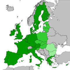
English: Enlargements 2004 and 2007:
European Union before the enlargement 2004
Enlargement 2004
Enlargement 2007 Svenska: Utvidgningarna 2004 och 2007:
Europeiska unionen innan utvidgningen 2004
Utvidgningen 2004
Utvidgningen 2007 |
| Date | |
| Source | Europe-countries-outline-iso-coded-plain.svg |
| Author | Original map created by Mfloryan, modified by Nablicus |
| SVG development |
Licensing[edit]
This file is licensed under the Creative Commons Attribution-Share Alike 4.0 International license.
- You are free:
- to share – to copy, distribute and transmit the work
- to remix – to adapt the work
- Under the following conditions:
- attribution – You must give appropriate credit, provide a link to the license, and indicate if changes were made. You may do so in any reasonable manner, but not in any way that suggests the licensor endorses you or your use.
- share alike – If you remix, transform, or build upon the material, you must distribute your contributions under the same or compatible license as the original.
File history
Click on a date/time to view the file as it appeared at that time.
| Date/Time | Thumbnail | Dimensions | User | Comment | |
|---|---|---|---|---|---|
| current | 14:22, 9 September 2023 | | 610 × 610 (472 KB) | Nablicus (talk | contribs) | adjustment |
| 08:17, 23 April 2020 |  | 610 × 610 (472 KB) | Nablicus (talk | contribs) | adjusted color | |
| 20:16, 22 April 2020 |  | 610 × 610 (472 KB) | Nablicus (talk | contribs) | new version | |
| 16:16, 10 April 2020 |  | 610 × 610 (475 KB) | Nablicus (talk | contribs) | minor adjustments | |
| 07:09, 18 July 2018 |  | 610 × 610 (342 KB) | Nablicus (talk | contribs) | correction, Austria | |
| 07:07, 18 July 2018 |  | 610 × 610 (342 KB) | Nablicus (talk | contribs) | added Montenegro, which existed at the time Bulgaria and Romania acceded the EU | |
| 12:41, 3 January 2018 |  | 610 × 610 (340 KB) | Nablicus (talk | contribs) | new version | |
| 09:53, 7 October 2011 |  | 645 × 690 (532 KB) | Stefan2 (talk | contribs) | Faroe Islands separated from Denmark and marked as non-EU using Gedit. The Isle of Man needs to be separated from the UK and marked as non-EU as well, but I couldn't locate the right coordinates in my text editor. Might try again later. Fixed a few capita | |
| 06:32, 21 June 2011 |  | 645 × 690 (532 KB) | Nablicus (talk | contribs) | this map does only include members 2004-2007 (se file name) | |
| 00:55, 21 June 2011 |  | 645 × 690 (532 KB) | Brightgalrs (talk | contribs) | Croatia, due to enter in 2013 |
You cannot overwrite this file.
File usage on Commons
The following 3 pages use this file:
File usage on other wikis
The following other wikis use this file: