File:ED Black Sea map - FC2 - april 2010.svg
Jump to navigation
Jump to search

Size of this PNG preview of this SVG file: 800 × 420 pixels. Other resolutions: 320 × 168 pixels | 640 × 336 pixels | 1,024 × 537 pixels | 1,280 × 672 pixels | 2,560 × 1,343 pixels | 1,052 × 552 pixels.
Original file (SVG file, nominally 1,052 × 552 pixels, file size: 1.05 MB)
Captions
Captions
Add a one-line explanation of what this file represents
Summary[edit]
| Description |
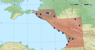
English: Eagle Dynamics' Flaming Cliffs 2 area of interest map. The numbers start from 12 because this map takes into account former bases from previous Eagle Dynamics works. |
| Date | |
| Source |
Own work Sources of data :
|
| Author | Flappiefh |
| Other versions |
|


Licensing[edit]
I, the copyright holder of this work, hereby publish it under the following license:
This file is licensed under the Creative Commons Attribution-Share Alike 4.0 International license.
- You are free:
- to share – to copy, distribute and transmit the work
- to remix – to adapt the work
- Under the following conditions:
- attribution – You must give appropriate credit, provide a link to the license, and indicate if changes were made. You may do so in any reasonable manner, but not in any way that suggests the licensor endorses you or your use.
- share alike – If you remix, transform, or build upon the material, you must distribute your contributions under the same or compatible license as the original.
File history
Click on a date/time to view the file as it appeared at that time.
| Date/Time | Thumbnail | Dimensions | User | Comment | |
|---|---|---|---|---|---|
| current | 22:32, 24 January 2018 | | 1,052 × 552 (1.05 MB) | Flappiefh (talk | contribs) | Textes en formes pour une meilleure lecture (police DejaVu Sans). |
| 22:06, 24 January 2018 |  | 1,052 × 552 (1.03 MB) | Flappiefh (talk | contribs) | User created page with UploadWizard |
You cannot overwrite this file.
File usage on Commons
The following 5 pages use this file:
File usage on other wikis
The following other wikis use this file:
- Usage on en.wikipedia.org
- Usage on fr.wikipedia.org