File:EB9 Kentucky - geological map.jpg
Jump to navigation
Jump to search

Size of this preview: 800 × 453 pixels. Other resolutions: 320 × 181 pixels | 640 × 362 pixels | 1,256 × 711 pixels.
Original file (1,256 × 711 pixels, file size: 192 KB, MIME type: image/jpeg)
Captions
Captions
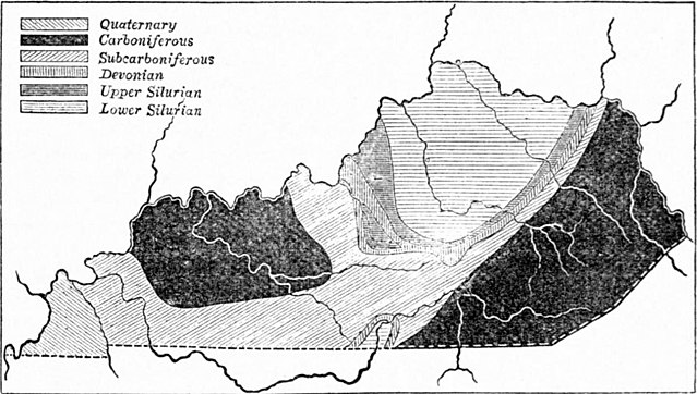
Map of the geological divisions of Kentucky
| Description |
English: Geological map of Kentucky. |
|||
| Date | ||||
| Source | "Kentucky" in the Encyclopædia Britannica, Vol. XIV, p. 41. | |||
| Author | Anonymous, but presumably engraved by John Bartholomew & Son or by William & Alexander Keith Johnston | |||
| Permission (Reusing this file) |
|

File history
Click on a date/time to view the file as it appeared at that time.
| Date/Time | Thumbnail | Dimensions | User | Comment | |
|---|---|---|---|---|---|
| current | 18:25, 30 June 2013 | | 1,256 × 711 (192 KB) | Bob Burkhardt (talk | contribs) | {{Information |Description={{en|Geological map of Kentucky.}} |Source=''Encyclopædia Britannica'', v. 14, 1882, p. 41. |Date=published 1882 |Author=not specified; article is by John R. Procter |Permission={{PD-Britannica}} |other_versions= }} [[Catego... |
You cannot overwrite this file.
File usage on Commons
There are no pages that use this file.
File usage on other wikis
The following other wikis use this file:
- Usage on bn.wikipedia.org
- Usage on en.wikisource.org
- Usage on id.wikipedia.org