File:EARS-Net MRSA 2012.svg
Jump to navigation
Jump to search

Size of this PNG preview of this SVG file: 528 × 462 pixels. Other resolutions: 274 × 240 pixels | 549 × 480 pixels | 878 × 768 pixels | 1,170 × 1,024 pixels | 2,341 × 2,048 pixels.
Original file (SVG file, nominally 528 × 462 pixels, file size: 207 KB)
Captions
Captions
Add a one-line explanation of what this file represents
W3C-validity not checked.
This W3C-unspecified vector image was created with Adobe Illustrator.
Summary[edit]
| Description |
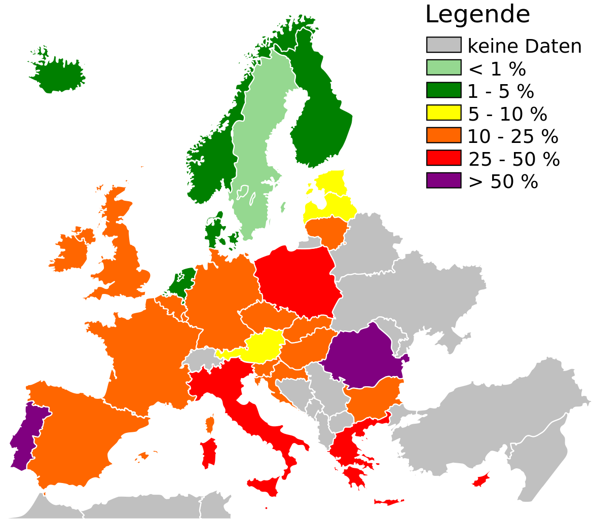
English: Proportion of Methicillin Resistant Staphylococcus aureus (MRSA) isolates in participating countries in 2012. Only data from invasive (blood and cerebrospinal fluid) isolates are included. Routine antimicrobial susceptibility test results are collected from clinical laboratories by the national representative in each participating country. Interpretation of the results should be undertaken with caution. Please visit EARS-Net for further information. Deutsch: Anteil von MRSA-Isolaten (Methicillin-resistenter Staphylococcus aureus) der teilnehmenden Staaten 2012. Es sind nur Daten von invasiven (Blut und Liquor cerebrospinalis) Isolaten erfasst. Die Ergebnisse von Routinetests über die Antibiotikaempfindlichkeit werden in klinischen Laboratorien durch nationale Beauftragte der teilnehmenden Staaten gesammelt. Die Interpretation der Ergebnisse sollte mit Bedacht erfolgen. Bitte die Webseite der EARS-Net für weitere Informationen aufsuchen. |
| Date | |
| Source | |
| Author | Antimicrobial resistance interactive database (EARS-Net), part of the European Centre for Disease Prevention and Control (ECDC) |
Licensing[edit]
This file is licensed under the Creative Commons Attribution-Share Alike 3.0 Unported license.
- You are free:
- to share – to copy, distribute and transmit the work
- to remix – to adapt the work
- Under the following conditions:
- attribution – You must give appropriate credit, provide a link to the license, and indicate if changes were made. You may do so in any reasonable manner, but not in any way that suggests the licensor endorses you or your use.
- share alike – If you remix, transform, or build upon the material, you must distribute your contributions under the same or compatible license as the original.
File history
Click on a date/time to view the file as it appeared at that time.
| Date/Time | Thumbnail | Dimensions | User | Comment | |
|---|---|---|---|---|---|
| current | 15:30, 29 May 2014 | | 528 × 462 (207 KB) | A doubt (talk | contribs) | changes for valid SVG code |
| 15:25, 29 May 2014 |  | 528 × 462 (207 KB) | A doubt (talk | contribs) | changes for valid source code | |
| 15:14, 29 May 2014 |  | 528 × 462 (207 KB) | A doubt (talk | contribs) | altered dimensions | |
| 14:39, 29 May 2014 |  | 811 × 520 (207 KB) | A doubt (talk | contribs) | User created page with UploadWizard |
You cannot overwrite this file.
File usage on Commons
There are no pages that use this file.
File usage on other wikis
The following other wikis use this file:
- Usage on de.wikipedia.org
- Usage on sv.wikipedia.org