File:Dutch Empire35.PNG
Jump to navigation
Jump to search
Size of this preview: 800 × 426 pixels. Other resolutions: 320 × 170 pixels | 640 × 341 pixels | 1,024 × 545 pixels | 1,678 × 893 pixels.
Original file (1,678 × 893 pixels, file size: 61 KB, MIME type: image/png)
Captions
Captions
Add a one-line explanation of what this file represents

|
This locator map image could be re-created using vector graphics as an SVG file. This has several advantages; see Commons:Media for cleanup for more information. If an SVG form of this image is available, please upload it and afterwards replace this template with
{{vector version available|new image name}}.
It is recommended to name the SVG file “Dutch Empire35.svg”—then the template Vector version available (or Vva) does not need the new image name parameter. |
Summary[edit]
| Description |
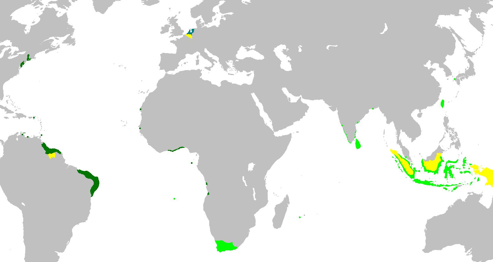
English: The Dutch Empire during the 17th and 18th centuries: in light green the Dutch East India Company, in dark green is the Dutch West India Company. In yellow the territories occupied later, during the 19th century. |
| Date | 5/5/08 |
| Source | Own work |
| Author | Red4tribe |
Licensing[edit]
I, the copyright holder of this work, hereby publish it under the following licenses:
This file is licensed under the Creative Commons Attribution-Share Alike 3.0 Unported license.
- You are free:
- to share – to copy, distribute and transmit the work
- to remix – to adapt the work
- Under the following conditions:
- attribution – You must give appropriate credit, provide a link to the license, and indicate if changes were made. You may do so in any reasonable manner, but not in any way that suggests the licensor endorses you or your use.
- share alike – If you remix, transform, or build upon the material, you must distribute your contributions under the same or compatible license as the original.

|
Permission is granted to copy, distribute and/or modify this document under the terms of the GNU Free Documentation License, Version 1.2 or any later version published by the Free Software Foundation; with no Invariant Sections, no Front-Cover Texts, and no Back-Cover Texts. A copy of the license is included in the section entitled GNU Free Documentation License. |
You may select the license of your choice.
File history
Click on a date/time to view the file as it appeared at that time.
| Date/Time | Thumbnail | Dimensions | User | Comment | |
|---|---|---|---|---|---|
| current | 21:25, 28 January 2013 | | 1,678 × 893 (61 KB) | Hazhk (talk | contribs) | Remove modern borders |
| 18:35, 20 October 2010 |  | 1,691 × 893 (51 KB) | -kayac71- (talk | contribs) | I corrected some errors in the map and put in yellow the territories occupied after the 18th century (that can not be attribute to one of the two Companies) | |
| 00:40, 6 May 2008 |  | 1,691 × 893 (86 KB) | Red4tribe (talk | contribs) | {{Information |Description=The Dutch Empire |Source=self-made |Date=5/5/08 |Author= Red4tribe |Permission= |other_versions= }} |
You cannot overwrite this file.
File usage on Commons
The following 2 pages use this file:
File usage on other wikis
The following other wikis use this file:
- Usage on af.wikipedia.org
- Usage on ar.wikipedia.org
- Usage on azb.wikipedia.org
- Usage on ba.wikipedia.org
- Usage on bg.wikipedia.org
- Usage on cs.wikipedia.org
- Usage on de.wikibooks.org
- Usage on el.wikipedia.org
- Usage on en.wikipedia.org
- Usage on en.wikibooks.org
- Usage on es.wikipedia.org
- Usage on es.wikibooks.org
- Usage on fa.wikipedia.org
- Usage on hu.wikipedia.org
- Usage on hy.wikipedia.org
- Usage on id.wikipedia.org
- Usage on io.wikipedia.org
- Usage on it.wikipedia.org
- Usage on ja.wikipedia.org
- Usage on lfn.wikipedia.org
- Usage on lt.wikipedia.org
- Usage on ms.wikipedia.org
- Usage on pl.wikipedia.org
- Usage on pnb.wikipedia.org
- Usage on pt.wikipedia.org
- Usage on pt.wikibooks.org
- Usage on qu.wikipedia.org
- Usage on ro.wikipedia.org
- Usage on ru.wikipedia.org
View more global usage of this file.