File:Dusky Pinnacles detail map.png
Jump to navigation
Jump to search

Size of this preview: 771 × 600 pixels. Other resolutions: 309 × 240 pixels | 617 × 480 pixels | 988 × 768 pixels | 1,280 × 995 pixels | 2,560 × 1,991 pixels | 7,800 × 6,066 pixels.
Original file (7,800 × 6,066 pixels, file size: 2.53 MB, MIME type: image/png)
Captions
Captions
Add a one-line explanation of what this file represents
Summary[edit]
| Description |
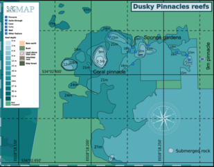
English: Map of the dive site Dusky Pinnacles off the West coast of the Cape Peninsula |
| Date | |
| Source | Own work |
| Author | Peter Southwood |
Licensing[edit]
I, the copyright holder of this work, hereby publish it under the following license:
This file is licensed under the Creative Commons Attribution-Share Alike 4.0 International license.
- You are free:
- to share – to copy, distribute and transmit the work
- to remix – to adapt the work
- Under the following conditions:
- attribution – You must give appropriate credit, provide a link to the license, and indicate if changes were made. You may do so in any reasonable manner, but not in any way that suggests the licensor endorses you or your use.
- share alike – If you remix, transform, or build upon the material, you must distribute your contributions under the same or compatible license as the original.
File history
Click on a date/time to view the file as it appeared at that time.
| Date/Time | Thumbnail | Dimensions | User | Comment | |
|---|---|---|---|---|---|
| current | 20:03, 24 March 2019 | | 7,800 × 6,066 (2.53 MB) | Pbsouthwood (talk | contribs) | added more 15m contour south of the pinnacles |
| 19:40, 3 February 2019 |  | 7,800 × 6,066 (2.46 MB) | Pbsouthwood (talk | contribs) | extended 21m contour and some corrections | |
| 14:48, 23 March 2018 |  | 5,000 × 3,888 (1.45 MB) | Pbsouthwood (talk | contribs) | User created page with UploadWizard |
You cannot overwrite this file.
File usage on Commons
The following 3 pages use this file:
File usage on other wikis
The following other wikis use this file:
- Usage on en.wikivoyage.org