File:Duke House.jpg
Original file (2,239 × 1,003 pixels, file size: 1.16 MB, MIME type: image/jpeg)
Captions
Summary[edit]
DescriptionDuke House.jpg |
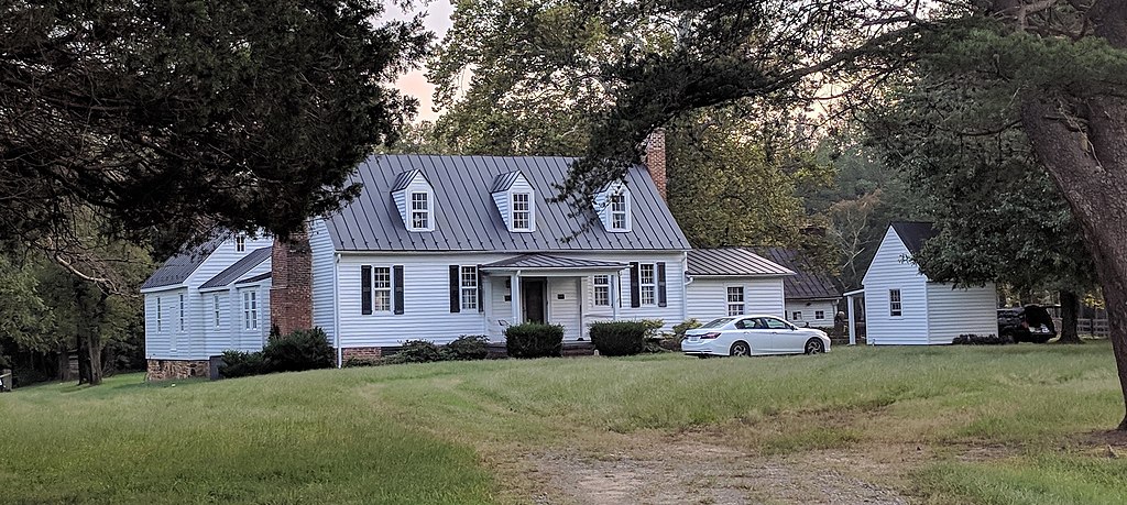
English: Duke House located at 2729 Diggstown Rd in Bumpass, Virginia. This is in Louisa County, location 37°56′44″N 77°46′23″W.
Duke House, also known as Little River Farm, is a historic home located at Bumpass, Louisa County, Virginia. It was built about 1790, and is a 1 1/2-story, frame dwelling sheathed with beaded weatherboards with an asymmetrical façade and double-shouldered exterior-end brick chimneys. It has a traditional single-pile, central-passage plan. A wing was added to the west end of the house during the first quarter of the 20th century. Also on the property are a contributing frame dependency and family cemetery. It was listed on the National Register of Historic Places in 2007. |
Date | |
Source | Own work |
Author | Colleendelawder |
Camera location | 37° 56′ 44″ N, 77° 46′ 23″ W | View this and other nearby images on: OpenStreetMap | 37.945556; -77.773056 |
---|
Licensing[edit]
- You are free:
- to share – to copy, distribute and transmit the work
- to remix – to adapt the work
- Under the following conditions:
- attribution – You must give appropriate credit, provide a link to the license, and indicate if changes were made. You may do so in any reasonable manner, but not in any way that suggests the licensor endorses you or your use.
- share alike – If you remix, transform, or build upon the material, you must distribute your contributions under the same or compatible license as the original.
This image was uploaded as part of Wiki Loves Monuments 2018.
Afrikaans ∙ Alemannisch ∙ azərbaycanca ∙ Bahasa Indonesia ∙ Bahasa Melayu ∙ Bikol Central ∙ bosanski ∙ brezhoneg ∙ català ∙ čeština ∙ Cymraeg ∙ dansk ∙ davvisámegiella ∙ Deutsch ∙ eesti ∙ English ∙ español ∙ Esperanto ∙ euskara ∙ français ∙ Frysk ∙ Gaeilge ∙ galego ∙ hrvatski ∙ Ido ∙ italiano ∙ latviešu ∙ Lëtzebuergesch ∙ Malagasy ∙ magyar ∙ Malti ∙ Nederlands ∙ norsk ∙ norsk nynorsk ∙ norsk bokmål ∙ polski ∙ português ∙ português do Brasil ∙ română ∙ shqip ∙ sicilianu ∙ slovenčina ∙ slovenščina ∙ suomi ∙ svenska ∙ Tagalog ∙ Türkçe ∙ Yorùbá ∙ Zazaki ∙ Ελληνικά ∙ беларуская ∙ беларуская (тарашкевіца) ∙ български ∙ кыргызча ∙ македонски ∙ русский ∙ српски / srpski ∙ українська ∙ ქართული ∙ հայերեն ∙ नेपाली ∙ हिन्दी ∙ বাংলা ∙ മലയാളം ∙ ไทย ∙ 한국어 ∙ +/− |
File history
Click on a date/time to view the file as it appeared at that time.
Date/Time | Thumbnail | Dimensions | User | Comment | |
---|---|---|---|---|---|
current | 23:27, 20 September 2018 | 2,239 × 1,003 (1.16 MB) | Colleendelawder (talk | contribs) | User created page with UploadWizard |
You cannot overwrite this file.
File usage on Commons
There are no pages that use this file.
Metadata
This file contains additional information such as Exif metadata which may have been added by the digital camera, scanner, or software program used to create or digitize it. If the file has been modified from its original state, some details such as the timestamp may not fully reflect those of the original file. The timestamp is only as accurate as the clock in the camera, and it may be completely wrong.
Camera manufacturer | |
---|---|
Camera model | Pixel |
Exposure time | 49/20,000 sec (0.00245) |
F-number | f/2 |
ISO speed rating | 50 |
Date and time of data generation | 18:32, 20 September 2018 |
Lens focal length | 4.67 mm |
Latitude | 37° 56′ 45.3″ N |
Longitude | 77° 46′ 19.47″ W |
Altitude | 51 meters above sea level |
Orientation | Normal |
Horizontal resolution | 72 dpi |
Vertical resolution | 72 dpi |
Software used | HDR+ 1.0.199571065z |
File change date and time | 18:32, 20 September 2018 |
Exposure Program | Normal program |
Exif version | 2.2 |
Date and time of digitizing | 18:32, 20 September 2018 |
Meaning of each component |
|
APEX shutter speed | 8.67 |
APEX aperture | 2 |
APEX brightness | 6.67 |
APEX exposure bias | 0 |
Maximum land aperture | 2 APEX (f/2) |
Subject distance | 1.652 meters |
Metering mode | Center weighted average |
Flash | Flash did not fire, auto mode |
DateTime subseconds | 017165 |
DateTimeOriginal subseconds | 017165 |
DateTimeDigitized subseconds | 017165 |
Supported Flashpix version | 1 |
Color space | sRGB |
Sensing method | One-chip color area sensor |
Scene type | A directly photographed image |
Custom image processing | Custom process |
Exposure mode | Auto exposure |
White balance | Auto white balance |
Digital zoom ratio | 0 |
Focal length in 35 mm film | 26 mm |
Scene capture type | Standard |
Contrast | Normal |
Saturation | Normal |
Sharpness | Normal |
Subject distance range | Close view |
GPS time (atomic clock) | 22:32 |
Measurement precision | Poor (66.52) |
GPS date | 20 September 2018 |
GPS tag version | 2.2.0.0 |
IIM version | 2 |
Structured data
Items portrayed in this file
depicts
20 September 2018
37°56'44.002"N, 77°46'23.002"W
0.00245 second
4.67 millimetre
- Files with coordinates missing SDC location of creation
- CC-BY-SA-4.0
- Self-published work
- Images from Wiki Loves Monuments 2018
- Images from Wiki Loves Monuments 2018 in the United States
- Images from Wiki Loves Monuments 2018 in Virginia
- Images from Wiki Loves Monuments missing SDC depicts
- Images from Wiki Loves Monuments missing SDC location of creation
- Wiki Loves Monuments 2018 in the United States unreviewed
- Uploaded via Campaign:wlm-us-other
- United States photographs taken on 2018-09-20
- Pages with maps