File:Ducatus Sleswicum sive Iutia Australis -map of Johannes Blaeu.jpg
Jump to navigation
Jump to search

Size of this preview: 401 × 599 pixels. Other resolutions: 160 × 240 pixels | 321 × 480 pixels | 514 × 768 pixels | 685 × 1,024 pixels | 1,338 × 2,000 pixels.
Original file (1,338 × 2,000 pixels, file size: 1.13 MB, MIME type: image/jpeg)
Captions
Captions
Add a one-line explanation of what this file represents
Summary[edit]
| Title |
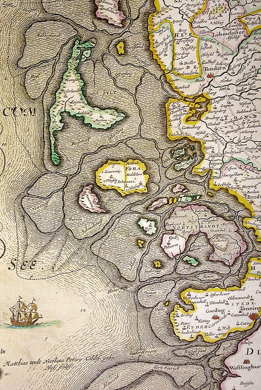
Latin: Ducatus Sleswicum sive Iutia Australis Duchy of Schleswig or Southern Jutland |
||||||||||||||||||||||||||||||||||||||||||||||||||
| Date | |||||||||||||||||||||||||||||||||||||||||||||||||||
| Source | Blaeu, Joan (1662) (in Latin) Atlas major, sive Cosmographia Blaviana, qua solum, salum, coelum, accuratissime describuntur, Amsterdam OCLC: 65862016. ; by Southgeist, December 2006 | ||||||||||||||||||||||||||||||||||||||||||||||||||
| Creator |
|
||||||||||||||||||||||||||||||||||||||||||||||||||
| Geotemporal data | |||||||||||||||||||||||||||||||||||||||||||||||||||
| Date depicted | |||||||||||||||||||||||||||||||||||||||||||||||||||
| Map location | North Frisia | ||||||||||||||||||||||||||||||||||||||||||||||||||
| Heading |
 |
||||||||||||||||||||||||||||||||||||||||||||||||||
| Georeferencing | If inappropriate please set warp_status = skip to hide. | ||||||||||||||||||||||||||||||||||||||||||||||||||
| Other versions | |||||||||||||||||||||||||||||||||||||||||||||||||||
.jpg)


Licensing[edit]
|
This is a faithful photographic reproduction of a two-dimensional, public domain work of art. The work of art itself is in the public domain for the following reason:
The official position taken by the Wikimedia Foundation is that "faithful reproductions of two-dimensional public domain works of art are public domain".
This photographic reproduction is therefore also considered to be in the public domain in the United States. In other jurisdictions, re-use of this content may be restricted; see Reuse of PD-Art photographs for details. | ||||
File history
Click on a date/time to view the file as it appeared at that time.
| Date/Time | Thumbnail | Dimensions | User | Comment | |
|---|---|---|---|---|---|
| current | 21:18, 25 December 2006 | | 1,338 × 2,000 (1.13 MB) | Southgeist (talk | contribs) | Map of Nordfriesland map from Johannes Blaeu, showing the flooded isle of Nortstrandt. Map was published in 1662, but was a remake of a map published by Johannes Meyer and Caspar Danckwerth in 1652 Category:Kreis Nordfriesland, Germany [[Category:Hi |
You cannot overwrite this file.
File usage on Commons
The following page uses this file:
File usage on other wikis
The following other wikis use this file:
- Usage on da.wikipedia.org
- Usage on de.wikipedia.org
- Usage on es.wikipedia.org
- Usage on frr.wikipedia.org
- Usage on fy.wikipedia.org